You are here: Home > Network List > TA - USArray Transportable Network (new EarthScope stations) Stations List
> Station J02A Umpqua, OR, USA > Earthquake Result Viewer
J02A Umpqua, OR, USA - Earthquake Result Viewer
| Earthquake location: |
South Of Panama |
| Earthquake latitude/longitude: |
6.6/-82.3 |
| Earthquake time(UTC): |
2006/01/06 (006) 03:39:58 GMT |
| Earthquake Depth: |
7.4 km |
| Earthquake Magnitude: |
5.9 MB, 5.5 MS, 6.1 MW, 6.0 MW |
| Earthquake Catalog/Contributor: |
WHDF/NEIC |
|
| Network: |
TA USArray Transportable Network (new EarthScope stations) |
| Station: |
J02A Umpqua, OR, USA |
| Lat/Lon: |
43.37 N/123.57 W |
| Elevation: |
136 m |
|
| Distance: |
51.4 deg |
| Az: |
322.064 deg |
| Baz: |
123.132 deg |
| Ray Param: |
0.067418985 |
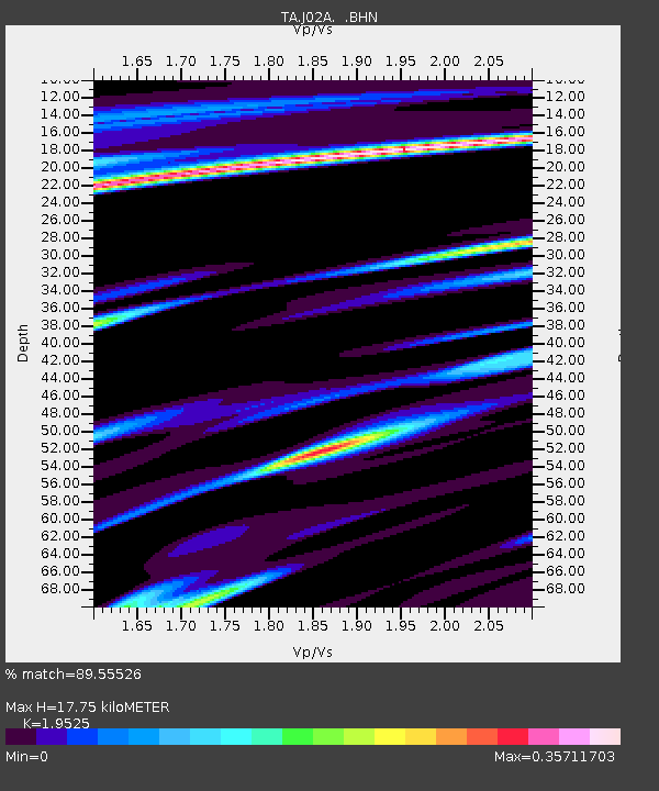
| Estimated Moho Depth: |
17.75 km |
| Estimated Crust Vp/Vs: |
1.95 |
| Assumed Crust Vp: |
6.522 km/s |
| Estimated Crust Vs: |
3.34 km/s |
| Estimated Crust Poisson's Ratio: |
0.32 |
|
| Radial Match: |
89.55526 % |
| Radial Bump: |
260 |
| Transverse Match: |
67.23102 % |
| Transverse Bump: |
400 |
| SOD ConfigId: |
132717 |
| Insert Time: |
2010-03-06 03:48:04.575 +0000 |
| GWidth: |
2.5 |
| Max Bumps: |
400 |
| Tol: |
0.001 |
|
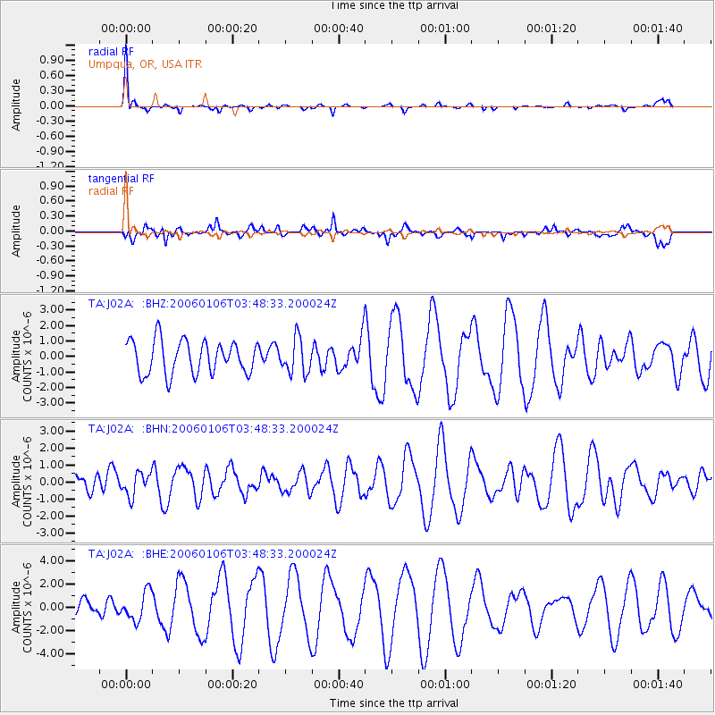
Signal To Noise
| Channel | StoN | STA | LTA |
| TA:J02A: :BHN:20060106T03:48:33.200024Z | 0.76455146 | 6.863884E-7 | 8.977661E-7 |
| TA:J02A: :BHE:20060106T03:48:33.200024Z | 1.7717165 | 1.2279936E-6 | 6.9310954E-7 |
| TA:J02A: :BHZ:20060106T03:48:33.200024Z | 1.0459855 | 1.1227687E-6 | 1.0734076E-6 |
| Arrivals |
| Ps | 2.7 SECOND |
| PpPs | 7.6 SECOND |
| PsPs/PpSs | 10 SECOND |


