You are here: Home > Network List > TA - USArray Transportable Network (new EarthScope stations) Stations List
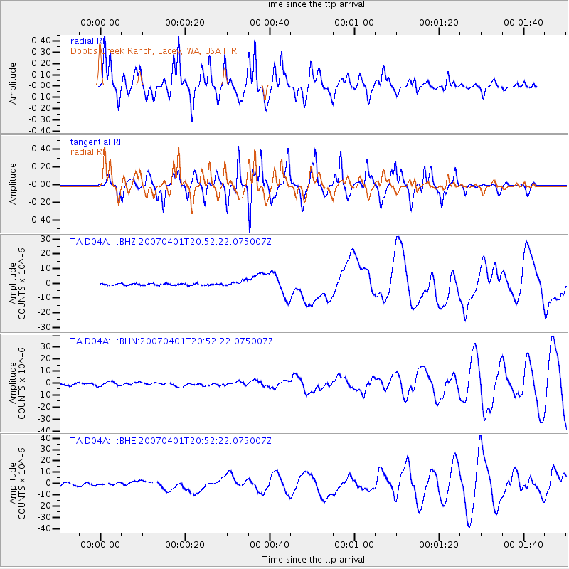
> Station D04A Dobbs Creek Ranch, Lacey, WA, USA > Earthquake Result Viewer
D04A Dobbs Creek Ranch, Lacey, WA, USA - Earthquake Result Viewer
| Earthquake location: |
Solomon Islands |
| Earthquake latitude/longitude: |
-8.5/157.0 |
| Earthquake time(UTC): |
2007/04/01 (091) 20:39:56 GMT |
| Earthquake Depth: |
10 km |
| Earthquake Magnitude: |
6.8 MB, 7.9 MS, 8.1 MW, 7.7 ME |
| Earthquake Catalog/Contributor: |
WHDF/NEIC |
|
| Network: |
TA USArray Transportable Network (new EarthScope stations) |
| Station: |
D04A Dobbs Creek Ranch, Lacey, WA, USA |
| Lat/Lon: |
47.11 N/122.80 W |
| Elevation: |
31 m |
|
| Distance: |
89.5 deg |
| Az: |
42.299 deg |
| Baz: |
257.091 deg |
| Ray Param: |
0.041808452 |
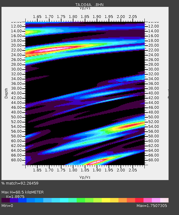
| Estimated Moho Depth: |
68.5 km |
| Estimated Crust Vp/Vs: |
1.90 |
| Assumed Crust Vp: |
6.566 km/s |
| Estimated Crust Vs: |
3.46 km/s |
| Estimated Crust Poisson's Ratio: |
0.31 |
|
| Radial Match: |
92.26459 % |
| Radial Bump: |
400 |
| Transverse Match: |
90.17732 % |
| Transverse Bump: |
344 |
| SOD ConfigId: |
2564 |
| Insert Time: |
2010-03-06 03:53:37.665 +0000 |
| GWidth: |
2.5 |
| Max Bumps: |
400 |
| Tol: |
0.001 |
|
Signal To Noise
| Channel | StoN | STA | LTA |
| TA:D04A: :BHN:20070401T20:52:22.075007Z | 2.1215796 | 1.7221563E-6 | 8.11733E-7 |
| TA:D04A: :BHE:20070401T20:52:22.075007Z | 0.75160044 | 8.224567E-7 | 1.0942738E-6 |
| TA:D04A: :BHZ:20070401T20:52:22.075007Z | 3.4781437 | 1.9160016E-6 | 5.50869E-7 |
| Arrivals |
| Ps | 9.6 SECOND |
| PpPs | 30 SECOND |
| PsPs/PpSs | 39 SECOND |


