You are here: Home > Network List > TA - USArray Transportable Network (new EarthScope stations) Stations List
> Station D04A Dobbs Creek Ranch, Lacey, WA, USA > Earthquake Result Viewer
D04A Dobbs Creek Ranch, Lacey, WA, USA - Earthquake Result Viewer
| Earthquake location: |
Near West Coast Of Colombia |
| Earthquake latitude/longitude: |
3.0/-78.0 |
| Earthquake time(UTC): |
2007/09/10 (253) 01:49:14 GMT |
| Earthquake Depth: |
31 km |
| Earthquake Magnitude: |
6.1 MB, 6.7 MS, 6.8 MW |
| Earthquake Catalog/Contributor: |
WHDF/NEIC |
|
| Network: |
TA USArray Transportable Network (new EarthScope stations) |
| Station: |
D04A Dobbs Creek Ranch, Lacey, WA, USA |
| Lat/Lon: |
47.11 N/122.80 W |
| Elevation: |
31 m |
|
| Distance: |
58.6 deg |
| Az: |
325.639 deg |
| Baz: |
124.389 deg |
| Ray Param: |
0.06270601 |
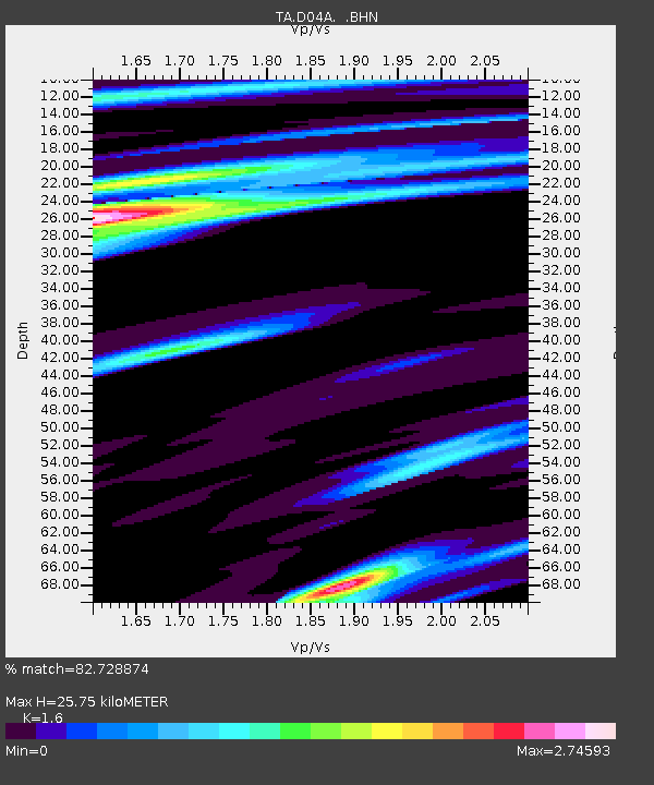
| Estimated Moho Depth: |
25.75 km |
| Estimated Crust Vp/Vs: |
1.60 |
| Assumed Crust Vp: |
6.566 km/s |
| Estimated Crust Vs: |
4.104 km/s |
| Estimated Crust Poisson's Ratio: |
0.18 |
|
| Radial Match: |
82.728874 % |
| Radial Bump: |
392 |
| Transverse Match: |
74.63112 % |
| Transverse Bump: |
400 |
| SOD ConfigId: |
2564 |
| Insert Time: |
2010-03-06 03:53:41.003 +0000 |
| GWidth: |
2.5 |
| Max Bumps: |
400 |
| Tol: |
0.001 |
|

Signal To Noise
| Channel | StoN | STA | LTA |
| TA:D04A: :BHN:20070910T01:58:37.149016Z | 0.8828825 | 1.0548067E-6 | 1.1947307E-6 |
| TA:D04A: :BHE:20070910T01:58:37.149016Z | 1.3510975 | 1.5473805E-6 | 1.1452767E-6 |
| TA:D04A: :BHZ:20070910T01:58:37.149016Z | 2.0295506 | 1.2810258E-6 | 6.31187E-7 |
| Arrivals |
| Ps | 2.5 SECOND |
| PpPs | 9.6 SECOND |
| PsPs/PpSs | 12 SECOND |


