You are here: Home > Network List > TA - USArray Transportable Network (new EarthScope stations) Stations List
> Station D03A Wishkah Elem. School, Wishkah, WA, USA > Earthquake Result Viewer
D03A Wishkah Elem. School, Wishkah, WA, USA - Earthquake Result Viewer
| Earthquake location: |
Solomon Islands |
| Earthquake latitude/longitude: |
-9.8/159.5 |
| Earthquake time(UTC): |
2007/08/16 (228) 08:39:27 GMT |
| Earthquake Depth: |
10 km |
| Earthquake Magnitude: |
6.1 MB, 6.7 MS, 6.4 MW |
| Earthquake Catalog/Contributor: |
WHDF/NEIC |
|
| Network: |
TA USArray Transportable Network (new EarthScope stations) |
| Station: |
D03A Wishkah Elem. School, Wishkah, WA, USA |
| Lat/Lon: |
47.12 N/123.77 W |
| Elevation: |
31 m |
|
| Distance: |
88.3 deg |
| Az: |
41.692 deg |
| Baz: |
253.691 deg |
| Ray Param: |
0.042713445 |
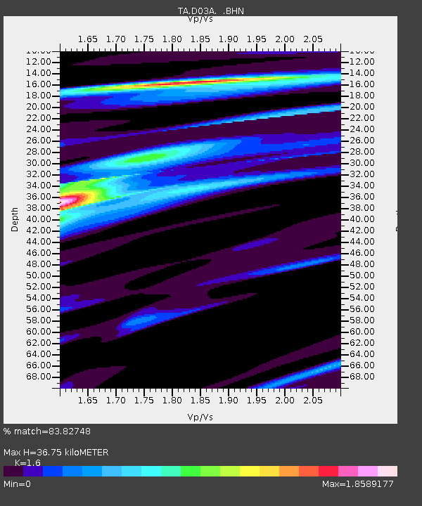
| Estimated Moho Depth: |
36.75 km |
| Estimated Crust Vp/Vs: |
1.60 |
| Assumed Crust Vp: |
6.566 km/s |
| Estimated Crust Vs: |
4.104 km/s |
| Estimated Crust Poisson's Ratio: |
0.18 |
|
| Radial Match: |
83.82748 % |
| Radial Bump: |
375 |
| Transverse Match: |
85.218315 % |
| Transverse Bump: |
400 |
| SOD ConfigId: |
2564 |
| Insert Time: |
2010-03-06 03:59:02.912 +0000 |
| GWidth: |
2.5 |
| Max Bumps: |
400 |
| Tol: |
0.001 |
|
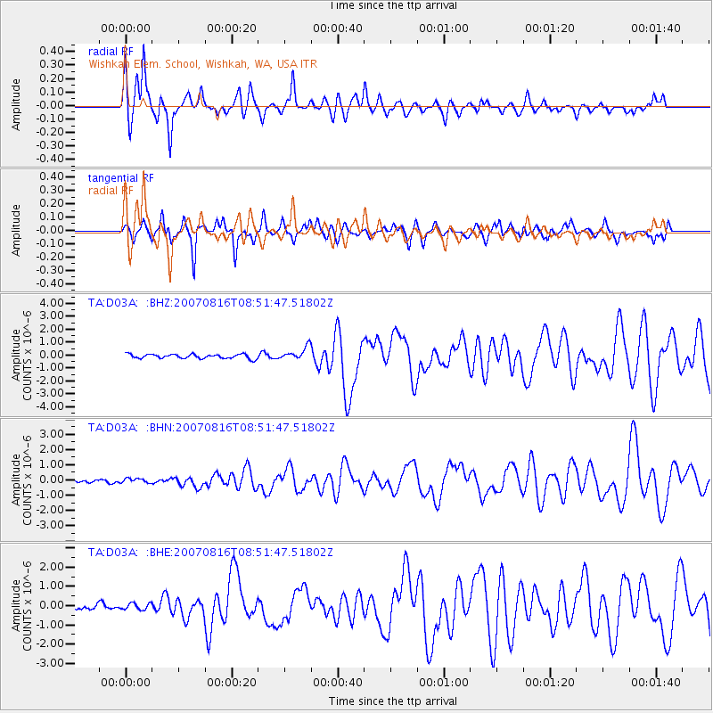
Signal To Noise
| Channel | StoN | STA | LTA |
| TA:D03A: :BHN:20070816T08:51:47.51802Z | 0.95793533 | 1.4888515E-7 | 1.5542295E-7 |
| TA:D03A: :BHE:20070816T08:51:47.51802Z | 1.2787087 | 1.7236097E-7 | 1.3479298E-7 |
| TA:D03A: :BHZ:20070816T08:51:47.51802Z | 3.0619676 | 5.0484095E-7 | 1.6487469E-7 |
| Arrivals |
| Ps | 3.4 SECOND |
| PpPs | 14 SECOND |
| PsPs/PpSs | 18 SECOND |


