
Station TA D03A - Wishkah Elem. School, Wishkah, WA, USA
Network: TA - USArray Transportable Network (new EarthScope stations)
Nearby stations (2 deg radius)
| Station | Name | (Lat, Lon) | Start / End | Elevation |
| D03A | Wishkah Elem. School, Wishkah, WA, USA | (47.12, -123.77) | 2004-09-16 / 2499-01-01 | 31 m |
| Crust2 Type: | L8,thin continental arc, Cordilleras, 0.5 km seds. |
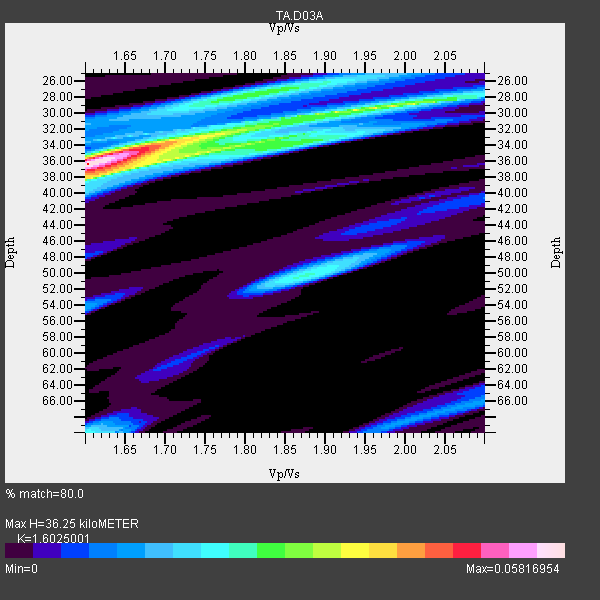
| Thickness Estimate: | 36 km |
| Thickness StdDev: | 3.5 km |
| Vp/Vs Estimate: | 1.60 |
| Vp/Vs StdDev: | 0.17 |
| Vs Estimate: | 4.097 km/s |
| Poisson's Ratio: | 0.18 |
| Peak Value: | 0.06 |
| Assumed Vp: | 6.566 km/s |
| Ps Weight: | 0.33333334 |
| PpPs Weight: | 0.33333334 |
| PsPs Weight: | 0.33333328 |
| Residual Complexity: | 0.707 |
| Nearby stations H: | +- |
| (2.0 deg) Vp/Vs: | +- |
0 with match > 90% ( 0.0 %) and 3 with match > 80% ( 75.0 %) out of 4.
Download stack as xyz text file.
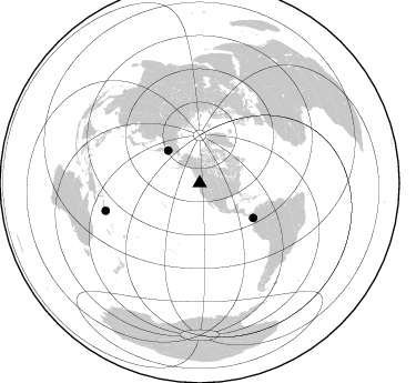
Azimuth Distribution of Events:
Prior Results for this Station
| Study | Thickness | Vp/Vs | Vp | Vs | Poissons Ratio | Extra |
| EARS | 36 km | 1.60 | 6.566 km/s | 4.097 km/s | 0.18 | |
| Crust2.0 | 34 km | 1.77 | 6.566 km/s | 3.707 km/s | 0.27 | L8,thin continental arc, Cordilleras, 0.5 km seds. |
| Global Maxima | 36 km | 1.60 | 6.566 km/s | 4.097 km/s | 0.18 | amp=0.05816954 |
| Local Maxima 1 | 29 km | 1.96 | 6.566 km/s | 3.35 km/s | 0.32 | amp=0.036123738 |
| Local Maxima 2 | 34 km | 1.69 | 6.566 km/s | 3.897 km/s | 0.23 | amp=0.02876489 |
| Local Maxima 3 | 28 km | 1.81 | 6.566 km/s | 3.623 km/s | 0.28 | amp=0.026071938 |
| Local Maxima 4 | 50 km | 1.87 | 6.566 km/s | 3.507 km/s | 0.30 | amp=0.023751797 |
| Predicted Arrivals for vertical incidence (zero ray parameter) | |
| Ps | 3.33 SECOND |
| PpPs | 14.37 SECOND |
| PsPs/PpSs | 17.69 SECOND |
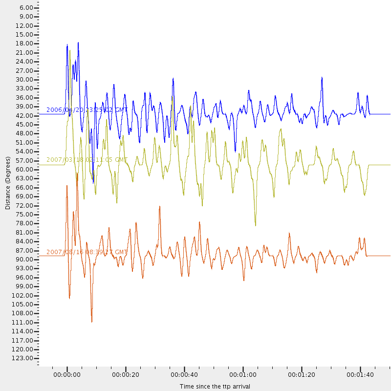
Events Processed for this Station
Download zip of receiver functions as SAC
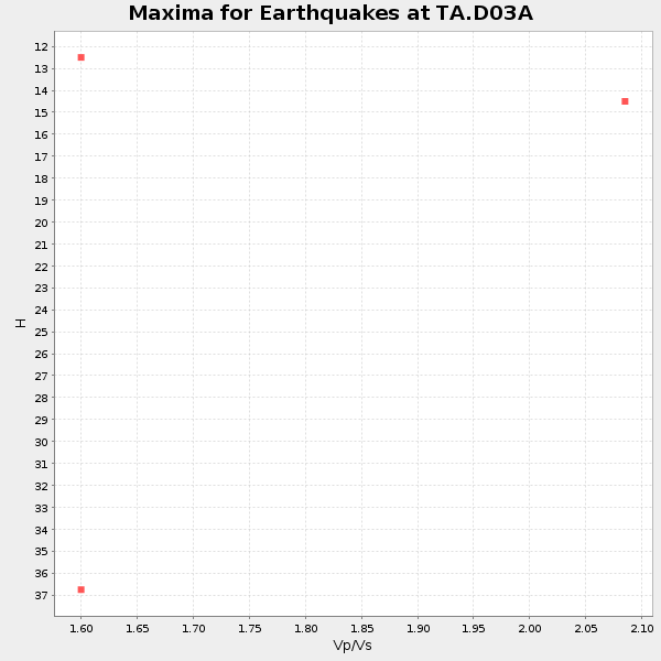
Plot maxima for each earthquake.
Events Used in the Stack
(3 events)| Radial Match | Distance | Baz | FERegion | Time | Lat/Lon | Depth | Magnitude |
| 83.82748 | 88.3 deg | 253.691 deg | Solomon Islands | 2007/08/16 08:39:27 GMT | (-9.8, 159.5) | 10 km | 6.1 MB, 6.7 MS, 6.4 MW |
| 82.64147 | 40.9 deg | 315.808 deg | Eastern Siberia, Russia | 2006/04/20 23:25:02 GMT | (60.9, 167.1) | 22 km | 6.8 MB, 7.6 MS, 7.6 MW, 7.3 MW |
| 81.662445 | 57.5 deg | 122.905 deg | South Of Panama | 2007/03/18 02:11:05 GMT | (4.6, -78.5) | 8.0 km | 6.4 MB, 5.7 MS, 6.2 MW, 6.1 MW |
Losers
(1 events)| Radial Match | Distance | Baz | FERegion | Time | Lat/Lon | Depth | Magnitude | Reason |
| 74.50547 | 47.7 deg | 126.035 deg | Near Coast Of Nicaragua | 2005/07/02 02:16:43 GMT | (11.2, -86.2) | 27 km | 5.6 MB, 6.4 MS, 6.6 MW, 6.6 MW |
