You are here: Home > Network List > TA - USArray Transportable Network (new EarthScope stations) Stations List
> Station D03A Wishkah Elem. School, Wishkah, WA, USA > Earthquake Result Viewer
D03A Wishkah Elem. School, Wishkah, WA, USA - Earthquake Result Viewer
| Earthquake location: |
South Of Panama |
| Earthquake latitude/longitude: |
4.6/-78.5 |
| Earthquake time(UTC): |
2007/03/18 (077) 02:11:05 GMT |
| Earthquake Depth: |
8.0 km |
| Earthquake Magnitude: |
6.4 MB, 5.7 MS, 6.2 MW, 6.1 MW |
| Earthquake Catalog/Contributor: |
WHDF/NEIC |
|
| Network: |
TA USArray Transportable Network (new EarthScope stations) |
| Station: |
D03A Wishkah Elem. School, Wishkah, WA, USA |
| Lat/Lon: |
47.12 N/123.77 W |
| Elevation: |
31 m |
|
| Distance: |
57.5 deg |
| Az: |
324.885 deg |
| Baz: |
122.905 deg |
| Ray Param: |
0.06344897 |
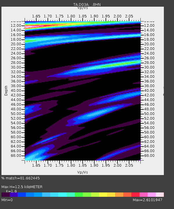
| Estimated Moho Depth: |
12.5 km |
| Estimated Crust Vp/Vs: |
1.60 |
| Assumed Crust Vp: |
6.566 km/s |
| Estimated Crust Vs: |
4.104 km/s |
| Estimated Crust Poisson's Ratio: |
0.18 |
|
| Radial Match: |
81.662445 % |
| Radial Bump: |
400 |
| Transverse Match: |
68.27261 % |
| Transverse Bump: |
400 |
| SOD ConfigId: |
2564 |
| Insert Time: |
2010-03-06 03:59:05.066 +0000 |
| GWidth: |
2.5 |
| Max Bumps: |
400 |
| Tol: |
0.001 |
|
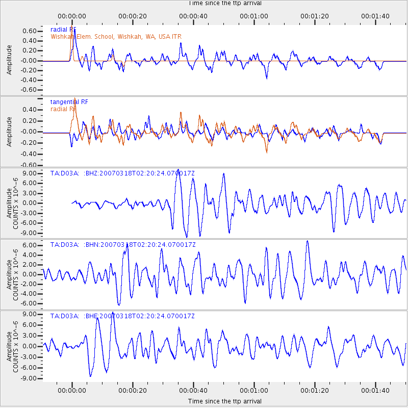
Signal To Noise
| Channel | StoN | STA | LTA |
| TA:D03A: :BHN:20070318T02:20:24.070017Z | 0.8312132 | 7.717141E-7 | 9.28419E-7 |
| TA:D03A: :BHE:20070318T02:20:24.070017Z | 1.2907295 | 1.223428E-6 | 9.478577E-7 |
| TA:D03A: :BHZ:20070318T02:20:24.070017Z | 6.2142725 | 4.0885566E-6 | 6.5793006E-7 |
| Arrivals |
| Ps | 1.2 SECOND |
| PpPs | 4.7 SECOND |
| PsPs/PpSs | 5.9 SECOND |


