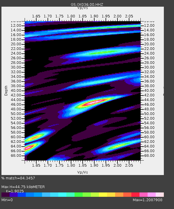
OK036 E0350 Rd betw N2450 and N2460, Cleo Springs, OK, USA - Earthquake Result Viewer
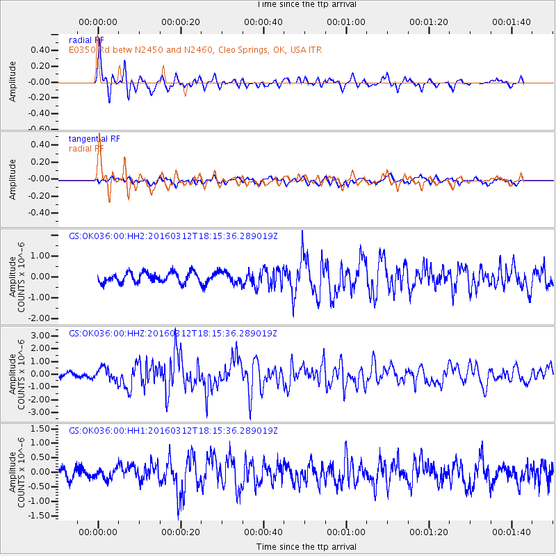
Earthquake location: Andreanof Islands, Aleutian Is.
Earthquake latitude/longitude: 51.6/-174.0
Earthquake time(UTC): 2016/03/12 (072) 18:06:45 GMT
Earthquake Depth: 19 km
Earthquake Magnitude: 6.3 MWW, 6.1 MB, 6.2 MWB, 6.3 MWC, 6.4 MWC, 6.4 MI
Earthquake Catalog/Contributor: NEIC PDE/NEIC COMCAT
Network: GS US Geological Survey Networks
Station: OK036 E0350 Rd betw N2450 and N2460, Cleo Springs, OK, USA
Lat/Lon: 36.51 N/98.63 W
Elevation: 460 m
Distance: 53.9 deg
Az: 74.855 deg
Baz: 311.594 deg
Ray Param: 0.06578518
Estimated Moho Depth: 44.75 km
Estimated Crust Vp/Vs: 1.90
Assumed Crust Vp: 6.426 km/s
Estimated Crust Vs: 3.378 km/s
Estimated Crust Poisson's Ratio: 0.31
Radial Match: 84.3457 %
Radial Bump: 400
Transverse Match: 52.218594 %
Transverse Bump: 400
SOD ConfigId: 1453031
Insert Time: 2016-03-26 18:26:18.545 +0000
GWidth: 2.5
Max Bumps: 400
Tol: 0.001

Signal To Noise

ChannelStoNSTALTA
GS:OK036:00:HHZ:20160312T18:15:36.289019Z4.1024125.06483E-71.2345981E-7
GS:OK036:00:HH1:20160312T18:15:36.289019Z0.91441411.7694106E-71.9350212E-7
GS:OK036:00:HH2:20160312T18:15:36.289019Z1.11797732.69077E-72.40682E-7
Arrivals
Ps6.6 SECOND
PpPs19 SECOND
PsPs/PpSs26 SECOND