
Station GS OK036 - E0350 Rd betw N2450 and N2460, Cleo Springs, OK, USA
Network: GS - US Geological Survey Networks
Nearby stations (2 deg radius)
| Station | Name | (Lat, Lon) | Start / End | Elevation |
| OK036 | E0350 Rd betw N2450 and N2460, Cleo Springs, OK, USA | (36.51, -98.63) | 2016-02-15 / 2599-12-31 | 460 m |
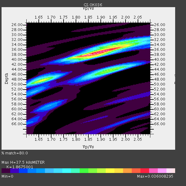
| Crust2 Type: | D8,thick Platform 3 km seds. |
| Thickness Estimate: | 38 km |
| Thickness StdDev: | 3.8 km |
| Vp/Vs Estimate: | 1.87 |
| Vp/Vs StdDev: | 0.06 |
| Vs Estimate: | 3.441 km/s |
| Poisson's Ratio: | 0.30 |
| Peak Value: | 0.04 |
| Assumed Vp: | 6.426 km/s |
| Ps Weight: | 0.33333334 |
| PpPs Weight: | 0.33333334 |
| PsPs Weight: | 0.33333328 |
| Residual Complexity: | 0.639 |
| Nearby stations H: | +- |
| (2.0 deg) Vp/Vs: | +- |
3 with match > 90% ( 17.647058 %) and 7 with match > 80% ( 41.17647 %) out of 17.
Download stack as xyz text file.
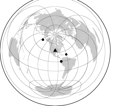
Azimuth Distribution of Events:
Prior Results for this Station
| Study | Thickness | Vp/Vs | Vp | Vs | Poissons Ratio | Extra |
| EARS | 38 km | 1.87 | 6.426 km/s | 3.441 km/s | 0.30 | |
| Crust2.0 | 46 km | 1.78 | 6.426 km/s | 3.613 km/s | 0.27 | D8,thick Platform 3 km seds. |
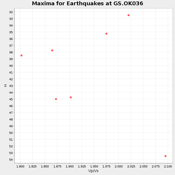
| Global Maxima | 38 km | 1.87 | 6.426 km/s | 3.441 km/s | 0.30 | amp=0.036008295 |
| Local Maxima 1 | 44 km | 1.96 | 6.426 km/s | 3.287 km/s | 0.32 | amp=0.021425698 |
| Local Maxima 2 | 35 km | 1.98 | 6.426 km/s | 3.254 km/s | 0.33 | amp=0.020677472 |
| Local Maxima 3 | 49 km | 1.64 | 6.426 km/s | 3.912 km/s | 0.21 | amp=0.012279175 |
| Local Maxima 4 | 46 km | 1.88 | 6.426 km/s | 3.427 km/s | 0.30 | amp=0.0112001775 |
| Predicted Arrivals for vertical incidence (zero ray parameter) | |
| Ps | 5.06 SECOND |
| PpPs | 16.73 SECOND |
| PsPs/PpSs | 21.80 SECOND |
Events Processed for this Station
Download zip of receiver functions as SAC
Plot maxima for each earthquake.
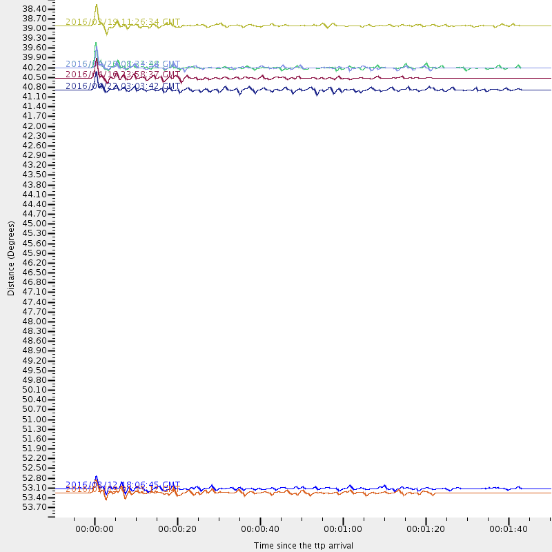
Events Used in the Stack
(7 events)| Radial Match | Distance | Baz | FERegion | Time | Lat/Lon | Depth | Magnitude |
| 96.10293 | 39.9 deg | 150.036 deg | Near Coast Of Ecuador | 2016/04/16 23:58:37 GMT | (0.4, -79.9) | 19 km | 7.8 MWW, 7.4 MI |
| 92.26003 | 39.6 deg | 150.35 deg | Near Coast Of Ecuador | 2016/04/20 08:33:48 GMT | (0.6, -80.3) | 16 km | 6.1 MO |
| 90.11774 | 38.1 deg | 108.635 deg | Leeward Islands | 2016/03/19 11:26:34 GMT | (18.0, -60.7) | 32 km | 6.0 MWW, 5.9 MWB |
| 86.52598 | 39.6 deg | 150.366 deg | Near Coast Of Ecuador | 2016/04/23 01:24:34 GMT | (0.6, -80.3) | 10 km | 5.8 MWP |
| 84.786354 | 40.3 deg | 151.321 deg | Near Coast Of Ecuador | 2016/04/22 03:03:42 GMT | (-0.3, -80.5) | 10 km | 6.0 MO |
| 84.3457 | 53.9 deg | 311.594 deg | Andreanof Islands, Aleutian Is. | 2016/03/12 18:06:45 GMT | (51.6, -174.0) | 19 km | 6.3 MWW, 6.1 MB, 6.2 MWB, 6.3 MWC, 6.4 MWC, 6.4 MI |
| 81.96235 | 54.0 deg | 311.578 deg | Andreanof Islands, Aleutian Is. | 2016/03/19 01:35:12 GMT | (51.5, -174.2) | 17 km | 6.0 MWW, 5.5 ML, 5.8 MWB |
Losers
(10 events)| Radial Match | Distance | Baz | FERegion | Time | Lat/Lon | Depth | Magnitude | Reason |
| 79.18255 | 43.9 deg | 317.304 deg | Alaska Peninsula | 2016/04/02 05:50:00 GMT | (57.0, -158.0) | 10 km | 6.2 MWP, 6.4 MI | |
| 76.15431 | 40.3 deg | 151.172 deg | Near Coast Of Ecuador | 2016/04/17 00:29:31 GMT | (-0.3, -80.5) | 16 km | 5.5 MB | |
| 73.12752 | 40.5 deg | 150.995 deg | Near Coast Of Ecuador | 2016/04/17 07:13:59 GMT | (-0.4, -80.3) | 10 km | 5.6 MB | |
| 67.60008 | 40.2 deg | 151.524 deg | Near Coast Of Ecuador | 2016/04/17 09:23:40 GMT | (-0.3, -80.7) | 10 km | 5.5 MB | |
| 62.39216 | 44.7 deg | 110.048 deg | North Atlantic Ocean | 2016/04/20 10:51:39 GMT | (13.2, -55.9) | 10 km | 5.8 MB | |
| 58.56506 | 50.5 deg | 311.566 deg | Fox Islands, Aleutian Islands | 2016/03/28 17:14:55 GMT | (52.3, -168.7) | 10 km | 5.5 MB, 5.6 MWC, 5.6 MWB | |
| 55.786785 | 93.0 deg | 242.893 deg | Tonga Islands Region | 2016/04/17 07:31:03 GMT | (-23.6, -174.3) | 35 km | 5.8 MB | |
| 51.51675 | 67.1 deg | 320.795 deg | Near East Coast Of Kamchatka | 2016/04/14 03:06:09 GMT | (53.9, 160.7) | 36 km | 5.8 MWW, 5.7 MWB, 5.8 MWC | |
| 45.53459 | 57.9 deg | 312.546 deg | Rat Islands, Aleutian Islands | 2016/04/10 19:34:02 GMT | (51.1, 179.5) | 19 km | 5.6 MWW, 5.3 ML, 5.4 MWB, 5.6 MWC, 5.7 ML | |
| 37.472336 | 59.3 deg | 314.08 deg | Rat Islands, Aleutian Islands | 2016/04/11 20:10:35 GMT | (51.8, 176.6) | 22 km | 5.6 MB, 5.5 MB, 5.6 MI |

