You are here: Home > Network List > OH - Ohio Seismic Network Stations List
> Station KLSO Kiser Lake State Park Ohio > Earthquake Result Viewer
KLSO Kiser Lake State Park Ohio - Earthquake Result Viewer
| Earthquake location: |
Rat Islands, Aleutian Islands |
| Earthquake latitude/longitude: |
52.4/176.8 |
| Earthquake time(UTC): |
2017/10/08 (281) 22:34:33 GMT |
| Earthquake Depth: |
112 km |
| Earthquake Magnitude: |
6.6 mww |
| Earthquake Catalog/Contributor: |
NEIC PDE/us |
|
| Network: |
OH Ohio Seismic Network |
| Station: |
KLSO Kiser Lake State Park Ohio |
| Lat/Lon: |
40.20 N/83.97 W |
| Elevation: |
350 m |
|
| Distance: |
64.3 deg |
| Az: |
57.025 deg |
| Baz: |
317.909 deg |
| Ray Param: |
0.05869507 |
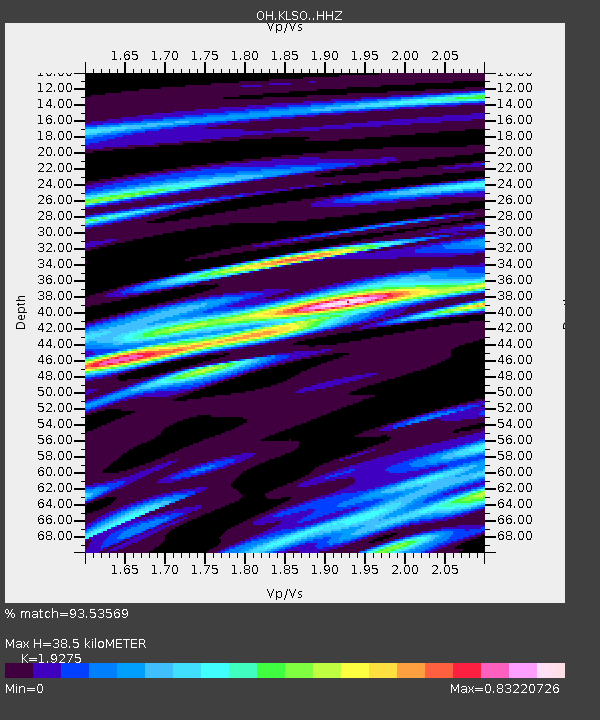
| Estimated Moho Depth: |
38.5 km |
| Estimated Crust Vp/Vs: |
1.93 |
| Assumed Crust Vp: |
6.498 km/s |
| Estimated Crust Vs: |
3.371 km/s |
| Estimated Crust Poisson's Ratio: |
0.32 |
|
| Radial Match: |
93.53569 % |
| Radial Bump: |
400 |
| Transverse Match: |
72.48888 % |
| Transverse Bump: |
400 |
| SOD ConfigId: |
13570011 |
| Insert Time: |
2019-04-28 23:18:16.717 +0000 |
| GWidth: |
2.5 |
| Max Bumps: |
400 |
| Tol: |
0.001 |
|

Signal To Noise
| Channel | StoN | STA | LTA |
| OH:KLSO: :HHZ:20171008T22:44:26.879983Z | 26.434944 | 6.2414765E-6 | 2.3610704E-7 |
| OH:KLSO: :HHN:20171008T22:44:26.879983Z | 13.87618 | 2.793724E-6 | 2.0133236E-7 |
| OH:KLSO: :HHE:20171008T22:44:26.879983Z | 10.20079 | 2.5809782E-6 | 2.5301748E-7 |
| Arrivals |
| Ps | 5.7 SECOND |
| PpPs | 17 SECOND |
| PsPs/PpSs | 22 SECOND |


