
Station OH KLSO - Kiser Lake State Park Ohio
Network: OH - Ohio Seismic Network
Nearby stations (2 deg radius)
| Station | Name | (Lat, Lon) | Start / End | Elevation |
| KLSO | Kiser Lake State Park Ohio | (40.20, -83.97) | 2016-01-03 / 2599-12-31 | 350 m |
| Crust2 Type: | D9,Platform 1 km seds. |
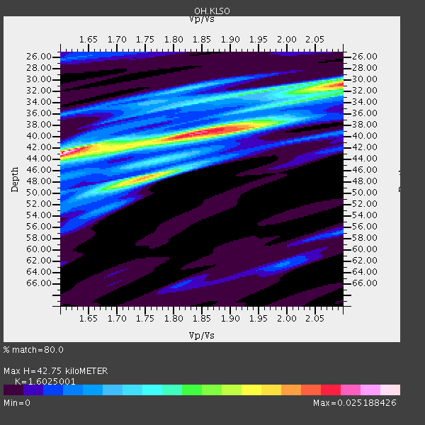
| Thickness Estimate: | 43 km |
| Thickness StdDev: | 5.0 km |
| Vp/Vs Estimate: | 1.60 |
| Vp/Vs StdDev: | 0.14 |
| Vs Estimate: | 4.055 km/s |
| Poisson's Ratio: | 0.18 |
| Peak Value: | 0.03 |
| Assumed Vp: | 6.498 km/s |
| Ps Weight: | 0.33333334 |
| PpPs Weight: | 0.33333334 |
| PsPs Weight: | 0.33333328 |
| Residual Complexity: | 0.801 |
| Nearby stations H: | +- |
| (2.0 deg) Vp/Vs: | +- |
3 with match > 90% ( 21.428572 %) and 4 with match > 80% ( 28.571428 %) out of 14.
Download stack as xyz text file.
Azimuth Distribution of Events:

Prior Results for this Station
| Study | Thickness | Vp/Vs | Vp | Vs | Poissons Ratio | Extra |
| EARS | 43 km | 1.60 | 6.498 km/s | 4.055 km/s | 0.18 | |
| Crust2.0 | 41 km | 1.77 | 6.498 km/s | 3.666 km/s | 0.27 | D9,Platform 1 km seds. |
| Global Maxima | 43 km | 1.60 | 6.498 km/s | 4.055 km/s | 0.18 | amp=0.025188426 |
| Local Maxima 1 | 31 km | 2.10 | 6.498 km/s | 3.101 km/s | 0.35 | amp=0.020293517 |
| Local Maxima 2 | 47 km | 1.75 | 6.498 km/s | 3.713 km/s | 0.26 | amp=0.017975 |
| Local Maxima 3 | 42 km | 1.71 | 6.498 km/s | 3.794 km/s | 0.24 | amp=0.011299573 |
| Local Maxima 4 | 38 km | 1.86 | 6.498 km/s | 3.489 km/s | 0.30 | amp=0.008624366 |
| Predicted Arrivals for vertical incidence (zero ray parameter) | |
| Ps | 3.96 SECOND |
| PpPs | 17.12 SECOND |
| PsPs/PpSs | 21.09 SECOND |
Events Processed for this Station
Download zip of receiver functions as SAC
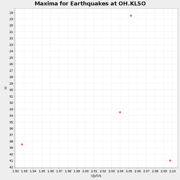
Plot maxima for each earthquake.
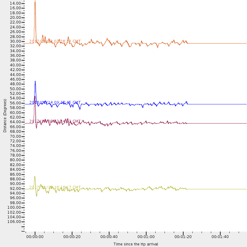
Events Used in the Stack
(4 events)| Radial Match | Distance | Baz | FERegion | Time | Lat/Lon | Depth | Magnitude |
| 95.14805 | 30.6 deg | 181.0 deg | Costa Rica | 2017/11/13 02:28:23 GMT | (9.5, -84.5) | 19 km | 6.5 mww |
| 93.53569 | 64.3 deg | 317.909 deg | Rat Islands, Aleutian Islands | 2017/10/08 22:34:33 GMT | (52.4, 176.8) | 112 km | 6.6 mww |
| 93.1452 | 56.3 deg | 169.311 deg | Near Coast Of Peru | 2018/01/14 09:18:45 GMT | (-15.8, -74.7) | 36 km | 7.1 mww |
| 80.29042 | 92.2 deg | 39.104 deg | Iran-Iraq Border Region | 2017/11/12 18:18:17 GMT | (34.9, 46.0) | 19 km | 7.3 Mww |
Losers
(10 events)| Radial Match | Distance | Baz | FERegion | Time | Lat/Lon | Depth | Magnitude | Reason |
| 79.89561 | 59.9 deg | 164.253 deg | Northern Chile | 2017/10/10 06:32:20 GMT | (-18.5, -69.6) | 82 km | 6.3 Mww | |
| 71.176834 | 60.3 deg | 164.319 deg | Northern Chile | 2018/01/21 01:06:42 GMT | (-18.9, -69.6) | 111 km | 6.3 Mww | |
| 70.4673 | 54.9 deg | 170.919 deg | Near Coast Of Peru | 2017/11/29 06:29:05 GMT | (-14.5, -76.3) | 10 km | 5.7 Mww | |
| 63.029778 | 62.3 deg | 316.674 deg | Andreanof Islands, Aleutian Is. | 2018/02/08 11:04:01 GMT | (52.6, -179.5) | 211 km | 5.6 Mww | |
| 61.6154 | 88.8 deg | 326.907 deg | Hokkaido, Japan Region | 2018/01/24 10:51:20 GMT | (41.1, 142.3) | 40 km | 6.2 Mww | |
| 59.903767 | 91.1 deg | 323.803 deg | Off East Coast Of Honshu, Japan | 2017/10/06 07:59:33 GMT | (37.5, 144.0) | 10 km | 6.0 Mww | |
| 59.645252 | 40.6 deg | 174.33 deg | Near Coast Of Ecuador | 2017/12/03 11:19:06 GMT | (-0.5, -80.3) | 25 km | 6.0 Mww | |
| 57.732517 | 68.6 deg | 110.854 deg | Central Mid-Atlantic Ridge | 2017/11/30 06:32:52 GMT | (-1.1, -23.5) | 10 km | 6.5 Mi | |
| 49.57815 | 81.3 deg | 180.09 deg | West Chile Rise | 2017/11/10 12:01:34 GMT | (-41.5, -84.1) | 10 km | 5.8 Mww | |
| 46.973442 | 72.5 deg | 166.296 deg | San Juan Province, Argentina | 2018/01/28 23:53:14 GMT | (-31.3, -68.7) | 88 km | 5.4 Mww |

