You are here: Home > Network List > GS - US Geological Survey Networks Stations List
> Station OK036 E0350 Rd betw N2450 and N2460, Cleo Springs, OK, USA > Earthquake Result Viewer
OK036 E0350 Rd betw N2450 and N2460, Cleo Springs, OK, USA - Earthquake Result Viewer
| Earthquake location: |
Andreanof Islands, Aleutian Is. |
| Earthquake latitude/longitude: |
51.5/-174.2 |
| Earthquake time(UTC): |
2016/03/19 (079) 01:35:12 GMT |
| Earthquake Depth: |
17 km |
| Earthquake Magnitude: |
6.0 MWW, 5.5 ML, 5.8 MWB |
| Earthquake Catalog/Contributor: |
NEIC PDE/NEIC COMCAT |
|
| Network: |
GS US Geological Survey Networks |
| Station: |
OK036 E0350 Rd betw N2450 and N2460, Cleo Springs, OK, USA |
| Lat/Lon: |
36.51 N/98.63 W |
| Elevation: |
460 m |
|
| Distance: |
54.0 deg |
| Az: |
74.683 deg |
| Baz: |
311.578 deg |
| Ray Param: |
0.06569786 |
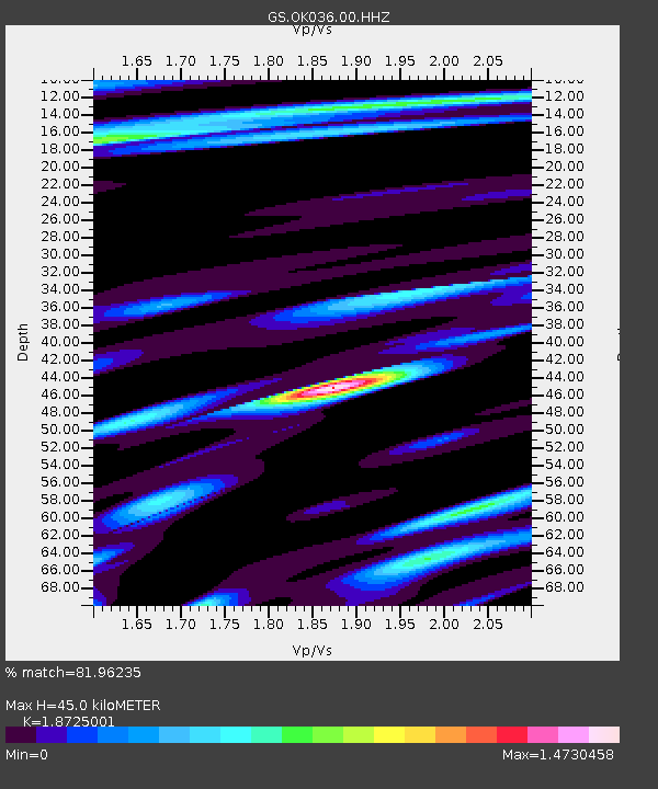
| Estimated Moho Depth: |
45.0 km |
| Estimated Crust Vp/Vs: |
1.87 |
| Assumed Crust Vp: |
6.426 km/s |
| Estimated Crust Vs: |
3.432 km/s |
| Estimated Crust Poisson's Ratio: |
0.30 |
|
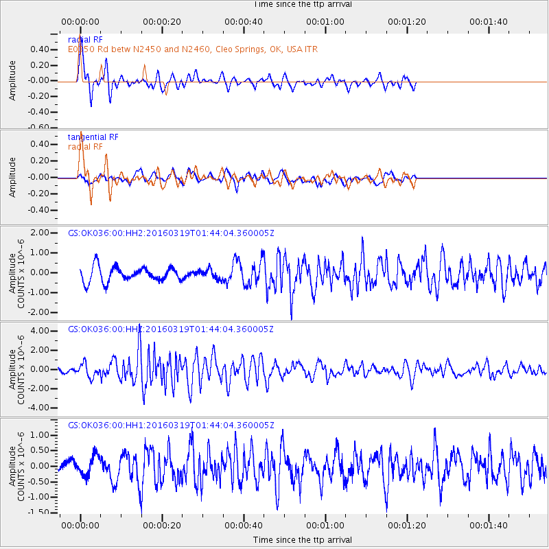
| Radial Match: |
81.96235 % |
| Radial Bump: |
400 |
| Transverse Match: |
65.65669 % |
| Transverse Bump: |
400 |
| SOD ConfigId: |
1464191 |
| Insert Time: |
2016-04-02 02:08:41.159 +0000 |
| GWidth: |
2.5 |
| Max Bumps: |
400 |
| Tol: |
0.001 |
|
Signal To Noise
| Channel | StoN | STA | LTA |
| GS:OK036:00:HHZ:20160319T01:44:04.360005Z | 4.354995 | 6.970805E-7 | 1.600646E-7 |
| GS:OK036:00:HH1:20160319T01:44:04.360005Z | 1.3844773 | 3.2940707E-7 | 2.3792884E-7 |
| GS:OK036:00:HH2:20160319T01:44:04.360005Z | 0.6454744 | 2.3744285E-7 | 3.678579E-7 |
| Arrivals |
| Ps | 6.4 SECOND |
| PpPs | 19 SECOND |
| PsPs/PpSs | 26 SECOND |


