You are here: Home > Network List > GS - US Geological Survey Networks Stations List
> Station OK042 N2343 and E0420 Rds, Waynoka, OK, USA > Earthquake Result Viewer
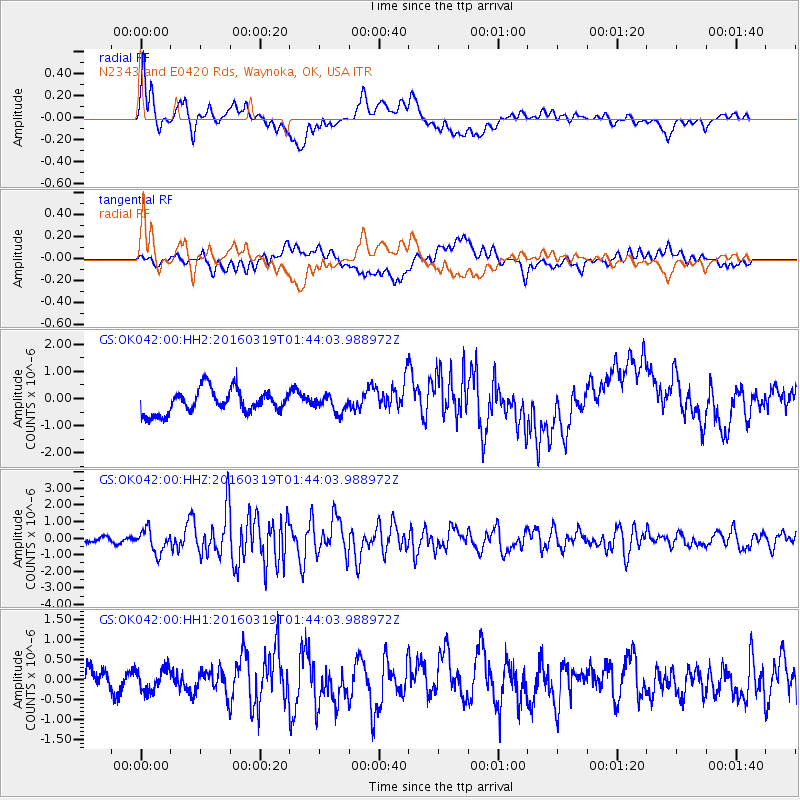
OK042 N2343 and E0420 Rds, Waynoka, OK, USA - Earthquake Result Viewer
*The percent match for this event was below the threshold and hence no stack was calculated.
| Earthquake location: |
Andreanof Islands, Aleutian Is. |
| Earthquake latitude/longitude: |
51.5/-174.2 |
| Earthquake time(UTC): |
2016/03/19 (079) 01:35:12 GMT |
| Earthquake Depth: |
17 km |
| Earthquake Magnitude: |
6.0 MWW, 5.5 ML, 5.8 MWB |
| Earthquake Catalog/Contributor: |
NEIC PDE/NEIC COMCAT |
|
| Network: |
GS US Geological Survey Networks |
| Station: |
OK042 N2343 and E0420 Rds, Waynoka, OK, USA |
| Lat/Lon: |
36.40 N/98.83 W |
| Elevation: |
442 m |
|
| Distance: |
54.0 deg |
| Az: |
74.91 deg |
| Baz: |
311.593 deg |
| Ray Param: |
$rayparam |
*The percent match for this event was below the threshold and hence was not used in the summary stack. |
|
| Radial Match: |
64.66675 % |
| Radial Bump: |
400 |
| Transverse Match: |
42.093826 % |
| Transverse Bump: |
400 |
| SOD ConfigId: |
1464191 |
| Insert Time: |
2016-04-02 02:09:32.263 +0000 |
| GWidth: |
2.5 |
| Max Bumps: |
400 |
| Tol: |
0.001 |
|
Signal To Noise
| Channel | StoN | STA | LTA |
| GS:OK042:00:HHZ:20160319T01:44:03.988972Z | 3.5499127 | 6.875276E-7 | 1.936745E-7 |
| GS:OK042:00:HH1:20160319T01:44:03.988972Z | 1.0792857 | 2.8210937E-7 | 2.6138525E-7 |
| GS:OK042:00:HH2:20160319T01:44:03.988972Z | 0.68465424 | 2.9666452E-7 | 4.3330562E-7 |
| Arrivals |
| Ps | |
| PpPs | |
| PsPs/PpSs | |


