
Station GS OK042 - N2343 and E0420 Rds, Waynoka, OK, USA
Network: GS - US Geological Survey Networks
Nearby stations (2 deg radius)
| Station | Name | (Lat, Lon) | Start / End | Elevation |
| OK042 | N2343 and E0420 Rds, Waynoka, OK, USA | (36.40, -98.83) | 2016-02-20 / 2599-12-31 | 442 m |
| Crust2 Type: | D8,thick Platform 3 km seds. |
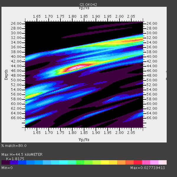
| Thickness Estimate: | 44 km |
| Thickness StdDev: | 8.7 km |
| Vp/Vs Estimate: | 1.82 |
| Vp/Vs StdDev: | 0.14 |
| Vs Estimate: | 3.536 km/s |
| Poisson's Ratio: | 0.28 |
| Peak Value: | 0.03 |
| Assumed Vp: | 6.426 km/s |
| Ps Weight: | 0.33333334 |
| PpPs Weight: | 0.33333334 |
| PsPs Weight: | 0.33333328 |
| Residual Complexity: | 0.751 |
| Nearby stations H: | +- |
| (2.0 deg) Vp/Vs: | +- |
2 with match > 90% ( 12.5 %) and 4 with match > 80% ( 25.0 %) out of 16.
Download stack as xyz text file.
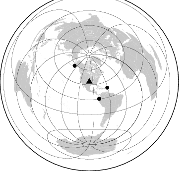
Azimuth Distribution of Events:
Prior Results for this Station
| Study | Thickness | Vp/Vs | Vp | Vs | Poissons Ratio | Extra |
| EARS | 44 km | 1.82 | 6.426 km/s | 3.536 km/s | 0.28 | |
| Crust2.0 | 46 km | 1.78 | 6.426 km/s | 3.613 km/s | 0.27 | D8,thick Platform 3 km seds. |
| Global Maxima | 44 km | 1.82 | 6.426 km/s | 3.536 km/s | 0.28 | amp=0.027739413 |
| Local Maxima 1 | 33 km | 2.07 | 6.426 km/s | 3.101 km/s | 0.35 | amp=0.02048143 |
| Local Maxima 2 | 40 km | 2.00 | 6.426 km/s | 3.221 km/s | 0.33 | amp=0.012984577 |
| Local Maxima 3 | 56 km | 1.63 | 6.426 km/s | 3.948 km/s | 0.20 | amp=0.012635379 |
| Local Maxima 4 | 34 km | 1.93 | 6.426 km/s | 3.321 km/s | 0.32 | amp=0.011608382 |
| Predicted Arrivals for vertical incidence (zero ray parameter) | |
| Ps | 5.66 SECOND |
| PpPs | 19.51 SECOND |
| PsPs/PpSs | 25.17 SECOND |
Events Processed for this Station
Download zip of receiver functions as SAC
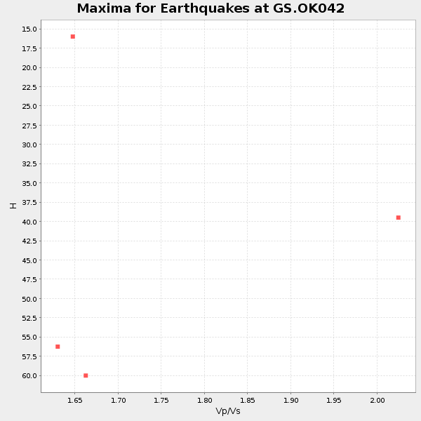
Plot maxima for each earthquake.
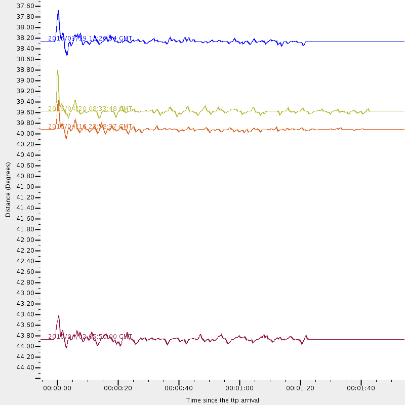
Events Used in the Stack
(4 events)| Radial Match | Distance | Baz | FERegion | Time | Lat/Lon | Depth | Magnitude |
| 97.274445 | 39.9 deg | 149.69 deg | Near Coast Of Ecuador | 2016/04/16 23:58:37 GMT | (0.4, -79.9) | 19 km | 7.8 MWW, 7.4 MI |
| 92.70518 | 39.6 deg | 150.001 deg | Near Coast Of Ecuador | 2016/04/20 08:33:48 GMT | (0.6, -80.3) | 16 km | 6.1 MO |
| 83.926346 | 38.2 deg | 108.328 deg | Leeward Islands | 2016/03/19 11:26:34 GMT | (18.0, -60.7) | 32 km | 6.0 MWW, 5.9 MWB |
| 83.27219 | 43.9 deg | 317.381 deg | Alaska Peninsula | 2016/04/02 05:50:00 GMT | (57.0, -158.0) | 10 km | 6.2 MWP, 6.4 MI |
Losers
(12 events)| Radial Match | Distance | Baz | FERegion | Time | Lat/Lon | Depth | Magnitude | Reason |
| 79.69365 | 40.3 deg | 150.979 deg | Near Coast Of Ecuador | 2016/04/22 03:03:42 GMT | (-0.3, -80.5) | 10 km | 6.0 MO | |
| 74.55409 | 40.2 deg | 151.18 deg | Near Coast Of Ecuador | 2016/04/17 09:23:40 GMT | (-0.3, -80.7) | 10 km | 5.5 MB | |
| 64.66675 | 54.0 deg | 311.593 deg | Andreanof Islands, Aleutian Is. | 2016/03/19 01:35:12 GMT | (51.5, -174.2) | 17 km | 6.0 MWW, 5.5 ML, 5.8 MWB | |
| 64.33452 | 53.8 deg | 311.61 deg | Andreanof Islands, Aleutian Is. | 2016/03/12 18:06:45 GMT | (51.6, -174.0) | 19 km | 6.3 MWW, 6.1 MB, 6.2 MWB, 6.3 MWC, 6.4 MWC, 6.4 MI | |
| 57.395367 | 96.7 deg | 319.588 deg | Kyushu, Japan | 2016/04/15 18:55:53 GMT | (33.0, 131.2) | 11 km | 5.5 MO | |
| 56.174393 | 74.8 deg | 155.774 deg | Chile-Argentina Border Region | 2016/04/14 09:38:44 GMT | (-33.9, -70.4) | 112 km | 5.5 MB | |
| 54.170647 | 93.5 deg | 316.465 deg | Near S. Coast Of Western Honshu | 2016/04/01 02:39:07 GMT | (33.4, 136.4) | 10 km | 6.0 MWP | |
| 53.612858 | 44.8 deg | 109.778 deg | North Atlantic Ocean | 2016/04/20 10:51:39 GMT | (13.2, -55.9) | 10 km | 5.8 MB | |
| 52.96931 | 73.5 deg | 57.649 deg | Strait Of Gibraltar | 2016/03/15 04:40:40 GMT | (35.8, -3.6) | 10 km | 5.6 MB | |
| 49.78306 | 92.9 deg | 242.774 deg | Tonga Islands Region | 2016/04/17 07:31:03 GMT | (-23.6, -174.3) | 35 km | 5.8 MB | |
| 41.676575 | 39.7 deg | 149.735 deg | Near Coast Of Ecuador | 2016/04/19 22:22:26 GMT | (0.6, -80.1) | 15 km | 5.5 MB | |
| 32.533558 | 97.1 deg | 319.73 deg | Kyushu, Japan | 2016/04/15 16:44:06 GMT | (32.7, 130.7) | 10 km | 5.8 MB |

