You are here: Home > Network List > IC - New China Digital Seismograph Network Stations List
> Station HIA Hailar, Neimenggu Autonomous Region, China > Earthquake Result Viewer
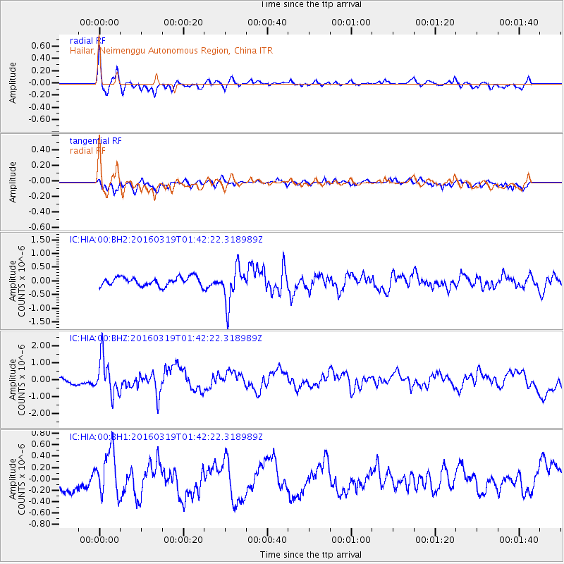
HIA Hailar, Neimenggu Autonomous Region, China - Earthquake Result Viewer
*The percent match for this event was below the threshold and hence no stack was calculated.
| Earthquake location: |
Andreanof Islands, Aleutian Is. |
| Earthquake latitude/longitude: |
51.5/-174.2 |
| Earthquake time(UTC): |
2016/03/19 (079) 01:35:12 GMT |
| Earthquake Depth: |
17 km |
| Earthquake Magnitude: |
6.0 MWW, 5.5 ML, 5.8 MWB |
| Earthquake Catalog/Contributor: |
NEIC PDE/NEIC COMCAT |
|
| Network: |
IC New China Digital Seismograph Network |
| Station: |
HIA Hailar, Neimenggu Autonomous Region, China |
| Lat/Lon: |
49.27 N/119.74 E |
| Elevation: |
620 m |
|
| Distance: |
40.9 deg |
| Az: |
293.835 deg |
| Baz: |
60.771 deg |
| Ray Param: |
$rayparam |
*The percent match for this event was below the threshold and hence was not used in the summary stack. |
|
| Radial Match: |
73.64177 % |
| Radial Bump: |
400 |
| Transverse Match: |
57.434174 % |
| Transverse Bump: |
400 |
| SOD ConfigId: |
1464191 |
| Insert Time: |
2016-04-02 02:10:18.431 +0000 |
| GWidth: |
2.5 |
| Max Bumps: |
400 |
| Tol: |
0.001 |
|
Signal To Noise
| Channel | StoN | STA | LTA |
| IC:HIA:00:BHZ:20160319T01:42:22.318989Z | 6.771682 | 1.1164292E-6 | 1.6486733E-7 |
| IC:HIA:00:BH1:20160319T01:42:22.318989Z | 2.3100572 | 4.1532064E-7 | 1.7978803E-7 |
| IC:HIA:00:BH2:20160319T01:42:22.318989Z | 4.3061595 | 6.8116725E-7 | 1.581844E-7 |
| Arrivals |
| Ps | |
| PpPs | |
| PsPs/PpSs | |


