You are here: Home > Network List > GS - US Geological Survey Networks Stations List
> Station OK036 E0350 Rd betw N2450 and N2460, Cleo Springs, OK, USA > Earthquake Result Viewer
OK036 E0350 Rd betw N2450 and N2460, Cleo Springs, OK, USA - Earthquake Result Viewer
| Earthquake location: |
Leeward Islands |
| Earthquake latitude/longitude: |
18.0/-60.7 |
| Earthquake time(UTC): |
2016/03/19 (079) 11:26:34 GMT |
| Earthquake Depth: |
32 km |
| Earthquake Magnitude: |
6.0 MWW, 5.9 MWB |
| Earthquake Catalog/Contributor: |
NEIC PDE/NEIC COMCAT |
|
| Network: |
GS US Geological Survey Networks |
| Station: |
OK036 E0350 Rd betw N2450 and N2460, Cleo Springs, OK, USA |
| Lat/Lon: |
36.51 N/98.63 W |
| Elevation: |
460 m |
|
| Distance: |
38.1 deg |
| Az: |
306.659 deg |
| Baz: |
108.635 deg |
| Ray Param: |
0.075680226 |
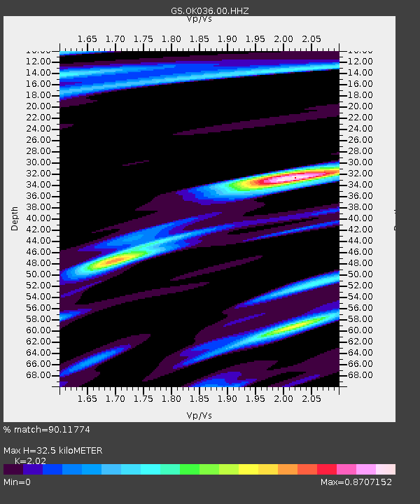
| Estimated Moho Depth: |
32.5 km |
| Estimated Crust Vp/Vs: |
2.02 |
| Assumed Crust Vp: |
6.426 km/s |
| Estimated Crust Vs: |
3.181 km/s |
| Estimated Crust Poisson's Ratio: |
0.34 |
|
| Radial Match: |
90.11774 % |
| Radial Bump: |
331 |
| Transverse Match: |
64.2713 % |
| Transverse Bump: |
400 |
| SOD ConfigId: |
1464191 |
| Insert Time: |
2016-04-02 12:02:40.738 +0000 |
| GWidth: |
2.5 |
| Max Bumps: |
400 |
| Tol: |
0.001 |
|
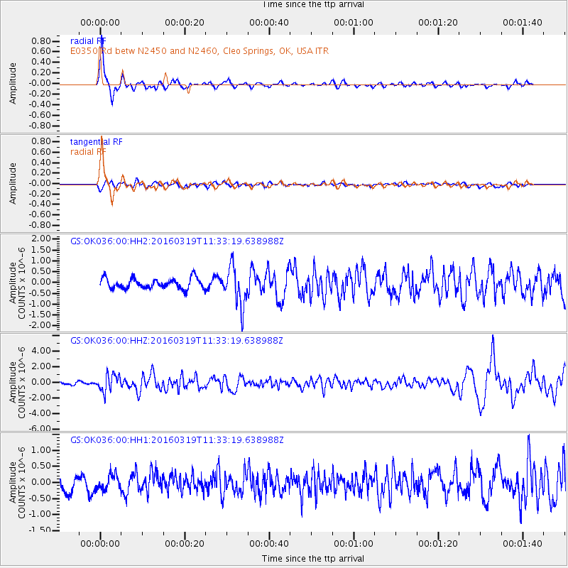
Signal To Noise
| Channel | StoN | STA | LTA |
| GS:OK036:00:HHZ:20160319T11:33:19.638988Z | 4.318194 | 1.0919316E-6 | 2.5286766E-7 |
| GS:OK036:00:HH1:20160319T11:33:19.638988Z | 0.90440035 | 2.2950064E-7 | 2.5376002E-7 |
| GS:OK036:00:HH2:20160319T11:33:19.638988Z | 3.8265688 | 9.124455E-7 | 2.3845004E-7 |
| Arrivals |
| Ps | 5.5 SECOND |
| PpPs | 14 SECOND |
| PsPs/PpSs | 20 SECOND |


