You are here: Home > Network List > GS - US Geological Survey Networks Stations List
> Station OK042 N2343 and E0420 Rds, Waynoka, OK, USA > Earthquake Result Viewer
OK042 N2343 and E0420 Rds, Waynoka, OK, USA - Earthquake Result Viewer

| Earthquake location: |
Leeward Islands |
| Earthquake latitude/longitude: |
18.0/-60.7 |
| Earthquake time(UTC): |
2016/03/19 (079) 11:26:34 GMT |
| Earthquake Depth: |
32 km |
| Earthquake Magnitude: |
6.0 MWW, 5.9 MWB |
| Earthquake Catalog/Contributor: |
NEIC PDE/NEIC COMCAT |
|
| Network: |
GS US Geological Survey Networks |
| Station: |
OK042 N2343 and E0420 Rds, Waynoka, OK, USA |
| Lat/Lon: |
36.40 N/98.83 W |
| Elevation: |
442 m |
|
| Distance: |
38.2 deg |
| Az: |
306.42 deg |
| Baz: |
108.328 deg |
| Ray Param: |
0.07561096 |
| Estimated Moho Depth: |
39.5 km |
| Estimated Crust Vp/Vs: |
2.03 |
| Assumed Crust Vp: |
6.426 km/s |
| Estimated Crust Vs: |
3.173 km/s |
| Estimated Crust Poisson's Ratio: |
0.34 |
|
| Radial Match: |
83.926346 % |
| Radial Bump: |
289 |
| Transverse Match: |
76.220055 % |
| Transverse Bump: |
400 |
| SOD ConfigId: |
1464191 |
| Insert Time: |
2016-04-02 12:03:03.480 +0000 |
| GWidth: |
2.5 |
| Max Bumps: |
400 |
| Tol: |
0.001 |
|
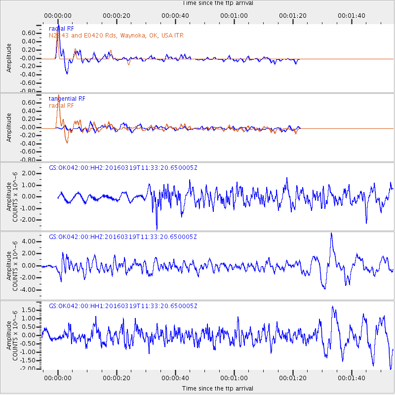
Signal To Noise
| Channel | StoN | STA | LTA |
| GS:OK042:00:HHZ:20160319T11:33:20.650005Z | 8.073182 | 1.1616366E-6 | 1.4388833E-7 |
| GS:OK042:00:HH1:20160319T11:33:20.650005Z | 1.5078086 | 2.759825E-7 | 1.8303551E-7 |
| GS:OK042:00:HH2:20160319T11:33:20.650005Z | 3.3722844 | 8.319893E-7 | 2.4671388E-7 |
| Arrivals |
| Ps | 6.7 SECOND |
| PpPs | 17 SECOND |
| PsPs/PpSs | 24 SECOND |


