You are here: Home > Network List > GS - US Geological Survey Networks Stations List
> Station OK041 County Line and E0380 Rds, Cleo Springs, OK, USA > Earthquake Result Viewer
OK041 County Line and E0380 Rds, Cleo Springs, OK, USA - Earthquake Result Viewer
| Earthquake location: |
Alaska Peninsula |
| Earthquake latitude/longitude: |
57.0/-158.0 |
| Earthquake time(UTC): |
2016/04/02 (093) 05:50:00 GMT |
| Earthquake Depth: |
10 km |
| Earthquake Magnitude: |
6.2 MWP, 6.4 MI |
| Earthquake Catalog/Contributor: |
NEIC PDE/NEIC COMCAT |
|
| Network: |
GS US Geological Survey Networks |
| Station: |
OK041 County Line and E0380 Rds, Cleo Springs, OK, USA |
| Lat/Lon: |
36.47 N/98.53 W |
| Elevation: |
445 m |
|
| Distance: |
44.0 deg |
| Az: |
91.646 deg |
| Baz: |
317.329 deg |
| Ray Param: |
0.072205946 |
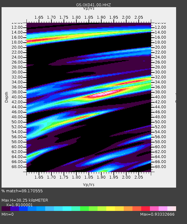
| Estimated Moho Depth: |
38.25 km |
| Estimated Crust Vp/Vs: |
1.91 |
| Assumed Crust Vp: |
6.426 km/s |
| Estimated Crust Vs: |
3.364 km/s |
| Estimated Crust Poisson's Ratio: |
0.31 |
|
| Radial Match: |
89.170555 % |
| Radial Bump: |
348 |
| Transverse Match: |
61.49059 % |
| Transverse Bump: |
400 |
| SOD ConfigId: |
1475611 |
| Insert Time: |
2016-04-16 06:03:40.922 +0000 |
| GWidth: |
2.5 |
| Max Bumps: |
400 |
| Tol: |
0.001 |
|

Signal To Noise
| Channel | StoN | STA | LTA |
| GS:OK041:00:HHZ:20160402T05:57:37.034015Z | 5.584776 | 1.229714E-6 | 2.201904E-7 |
| GS:OK041:00:HH1:20160402T05:57:37.034015Z | 2.078573 | 5.4811653E-7 | 2.636985E-7 |
| GS:OK041:00:HH2:20160402T05:57:37.034015Z | 2.0481482 | 5.616001E-7 | 2.7419892E-7 |
| Arrivals |
| Ps | 5.8 SECOND |
| PpPs | 16 SECOND |
| PsPs/PpSs | 22 SECOND |


