You are here: Home > Network List > GS - US Geological Survey Networks Stations List
> Station OK042 N2343 and E0420 Rds, Waynoka, OK, USA > Earthquake Result Viewer
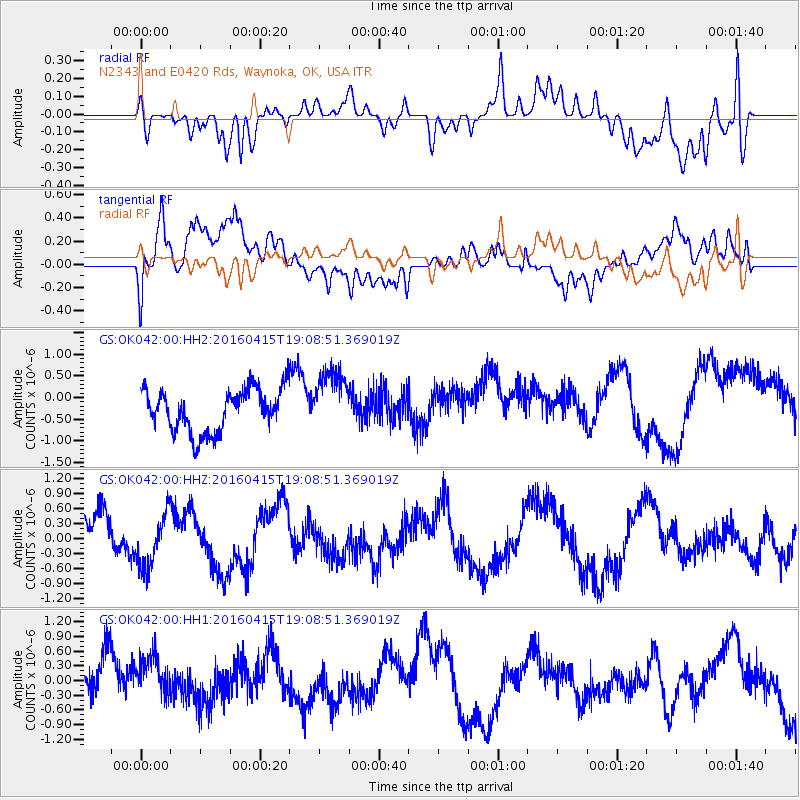
OK042 N2343 and E0420 Rds, Waynoka, OK, USA - Earthquake Result Viewer
*The percent match for this event was below the threshold and hence no stack was calculated.
| Earthquake location: |
Kyushu, Japan |
| Earthquake latitude/longitude: |
33.0/131.2 |
| Earthquake time(UTC): |
2016/04/15 (106) 18:55:53 GMT |
| Earthquake Depth: |
11 km |
| Earthquake Magnitude: |
5.5 MO |
| Earthquake Catalog/Contributor: |
NEIC PDE/NEIC ALERT |
|
| Network: |
GS US Geological Survey Networks |
| Station: |
OK042 N2343 and E0420 Rds, Waynoka, OK, USA |
| Lat/Lon: |
36.40 N/98.83 W |
| Elevation: |
442 m |
|
| Distance: |
96.7 deg |
| Az: |
38.471 deg |
| Baz: |
319.588 deg |
| Ray Param: |
$rayparam |
*The percent match for this event was below the threshold and hence was not used in the summary stack. |
|
| Radial Match: |
57.395367 % |
| Radial Bump: |
400 |
| Transverse Match: |
60.373825 % |
| Transverse Bump: |
400 |
| SOD ConfigId: |
1475611 |
| Insert Time: |
2016-04-29 19:12:49.574 +0000 |
| GWidth: |
2.5 |
| Max Bumps: |
400 |
| Tol: |
0.001 |
|
Signal To Noise
| Channel | StoN | STA | LTA |
| GS:OK042:00:HHZ:20160415T19:08:51.369019Z | 0.9782272 | 5.3589343E-7 | 5.4782106E-7 |
| GS:OK042:00:HH1:20160415T19:08:51.369019Z | 0.7641046 | 4.2816913E-7 | 5.6035407E-7 |
| GS:OK042:00:HH2:20160415T19:08:51.369019Z | 1.4306186 | 7.140678E-7 | 4.991322E-7 |
| Arrivals |
| Ps | |
| PpPs | |
| PsPs/PpSs | |


