You are here: Home > Network List > GS - US Geological Survey Networks Stations List
> Station OK041 County Line and E0380 Rds, Cleo Springs, OK, USA > Earthquake Result Viewer
OK041 County Line and E0380 Rds, Cleo Springs, OK, USA - Earthquake Result Viewer
| Earthquake location: |
Near Coast Of Ecuador |
| Earthquake latitude/longitude: |
0.4/-79.9 |
| Earthquake time(UTC): |
2016/04/16 (107) 23:58:37 GMT |
| Earthquake Depth: |
19 km |
| Earthquake Magnitude: |
7.8 MWW, 7.4 MI |
| Earthquake Catalog/Contributor: |
NEIC PDE/NEIC COMCAT |
|
| Network: |
GS US Geological Survey Networks |
| Station: |
OK041 County Line and E0380 Rds, Cleo Springs, OK, USA |
| Lat/Lon: |
36.47 N/98.53 W |
| Elevation: |
445 m |
|
| Distance: |
39.8 deg |
| Az: |
336.348 deg |
| Baz: |
150.154 deg |
| Ray Param: |
0.07472356 |
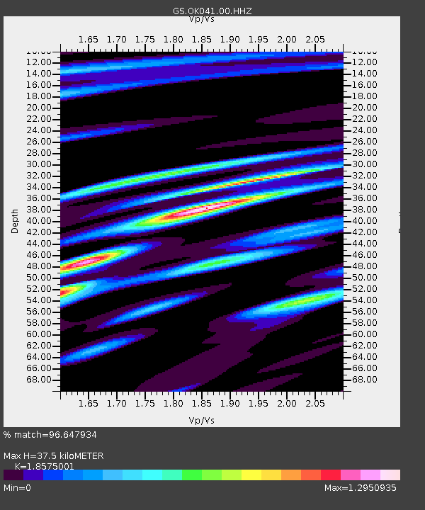
| Estimated Moho Depth: |
37.5 km |
| Estimated Crust Vp/Vs: |
1.86 |
| Assumed Crust Vp: |
6.426 km/s |
| Estimated Crust Vs: |
3.46 km/s |
| Estimated Crust Poisson's Ratio: |
0.30 |
|
| Radial Match: |
96.647934 % |
| Radial Bump: |
400 |
| Transverse Match: |
73.28024 % |
| Transverse Bump: |
400 |
| SOD ConfigId: |
1475611 |
| Insert Time: |
2016-05-01 00:05:49.368 +0000 |
| GWidth: |
2.5 |
| Max Bumps: |
400 |
| Tol: |
0.001 |
|

Signal To Noise
| Channel | StoN | STA | LTA |
| GS:OK041:00:HHZ:20160417T00:05:38.614015Z | 10.471137 | 3.763279E-6 | 3.5939544E-7 |
| GS:OK041:00:HH1:20160417T00:05:38.614015Z | 1.7703758 | 2.3396747E-6 | 1.3215695E-6 |
| GS:OK041:00:HH2:20160417T00:05:38.614015Z | 0.85503775 | 1.7662928E-6 | 2.0657485E-6 |
| Arrivals |
| Ps | 5.4 SECOND |
| PpPs | 16 SECOND |
| PsPs/PpSs | 21 SECOND |


