You are here: Home > Network List > OH - Ohio Seismic Network Stations List
> Station KLSO Kiser Lake State Park Ohio > Earthquake Result Viewer
KLSO Kiser Lake State Park Ohio - Earthquake Result Viewer
| Earthquake location: |
Near Coast Of Peru |
| Earthquake latitude/longitude: |
-15.8/-74.7 |
| Earthquake time(UTC): |
2018/01/14 (014) 09:18:45 GMT |
| Earthquake Depth: |
36 km |
| Earthquake Magnitude: |
7.1 mww |
| Earthquake Catalog/Contributor: |
NEIC PDE/us |
|
| Network: |
OH Ohio Seismic Network |
| Station: |
KLSO Kiser Lake State Park Ohio |
| Lat/Lon: |
40.20 N/83.97 W |
| Elevation: |
350 m |
|
| Distance: |
56.3 deg |
| Az: |
351.515 deg |
| Baz: |
169.311 deg |
| Ray Param: |
0.0641358 |
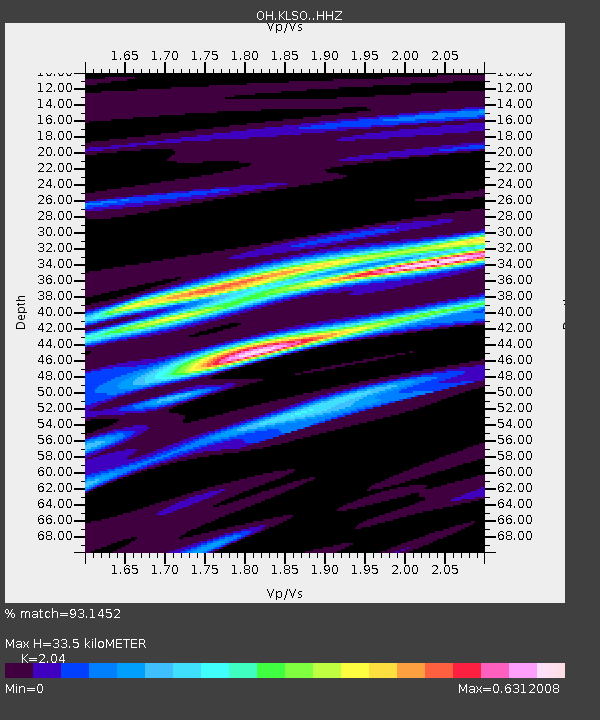
| Estimated Moho Depth: |
33.5 km |
| Estimated Crust Vp/Vs: |
2.04 |
| Assumed Crust Vp: |
6.498 km/s |
| Estimated Crust Vs: |
3.185 km/s |
| Estimated Crust Poisson's Ratio: |
0.34 |
|
| Radial Match: |
93.1452 % |
| Radial Bump: |
230 |
| Transverse Match: |
83.90457 % |
| Transverse Bump: |
400 |
| SOD ConfigId: |
13570011 |
| Insert Time: |
2019-04-29 13:41:42.308 +0000 |
| GWidth: |
2.5 |
| Max Bumps: |
400 |
| Tol: |
0.001 |
|

Signal To Noise
| Channel | StoN | STA | LTA |
| OH:KLSO: :HHZ:20180114T09:27:51.869988Z | 30.549025 | 1.5861238E-5 | 5.19206E-7 |
| OH:KLSO: :HHN:20180114T09:27:51.869988Z | 15.156211 | 7.198783E-6 | 4.7497247E-7 |
| OH:KLSO: :HHE:20180114T09:27:51.869988Z | 4.7764773 | 1.9341721E-6 | 4.0493694E-7 |
| Arrivals |
| Ps | 5.6 SECOND |
| PpPs | 15 SECOND |
| PsPs/PpSs | 21 SECOND |


