You are here: Home > Network List > OK - Oklahoma Seismic Network Stations List
> Station AMES Ames, Oklahoma, USA > Earthquake Result Viewer
AMES Ames, Oklahoma, USA - Earthquake Result Viewer
| Earthquake location: |
Near Coast Of Peru |
| Earthquake latitude/longitude: |
-15.8/-74.7 |
| Earthquake time(UTC): |
2018/01/14 (014) 09:18:45 GMT |
| Earthquake Depth: |
36 km |
| Earthquake Magnitude: |
7.1 mww |
| Earthquake Catalog/Contributor: |
NEIC PDE/us |
|
| Network: |
OK Oklahoma Seismic Network |
| Station: |
AMES Ames, Oklahoma, USA |
| Lat/Lon: |
36.34 N/98.19 W |
| Elevation: |
394 m |
|
| Distance: |
56.4 deg |
| Az: |
337.301 deg |
| Baz: |
152.604 deg |
| Ray Param: |
0.06411764 |
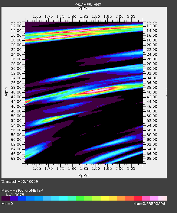
| Estimated Moho Depth: |
39.0 km |
| Estimated Crust Vp/Vs: |
1.91 |
| Assumed Crust Vp: |
6.426 km/s |
| Estimated Crust Vs: |
3.369 km/s |
| Estimated Crust Poisson's Ratio: |
0.31 |
|
| Radial Match: |
90.48059 % |
| Radial Bump: |
400 |
| Transverse Match: |
82.662704 % |
| Transverse Bump: |
400 |
| SOD ConfigId: |
13570011 |
| Insert Time: |
2019-04-29 13:41:46.113 +0000 |
| GWidth: |
2.5 |
| Max Bumps: |
400 |
| Tol: |
0.001 |
|

Signal To Noise
| Channel | StoN | STA | LTA |
| OK:AMES: :HHZ:20180114T09:27:52.134026Z | 45.556286 | 6.429688E-5 | 1.4113723E-6 |
| OK:AMES: :HHN:20180114T09:27:52.134026Z | 8.697227 | 1.6407183E-5 | 1.8864845E-6 |
| OK:AMES: :HHE:20180114T09:27:52.134026Z | 5.552512 | 1.1983532E-5 | 2.158218E-6 |
| Arrivals |
| Ps | 5.8 SECOND |
| PpPs | 17 SECOND |
| PsPs/PpSs | 23 SECOND |


