You are here: Home > Network List > GS - US Geological Survey Networks Stations List
> Station OK036 E0350 Rd betw N2450 and N2460, Cleo Springs, OK, USA > Earthquake Result Viewer
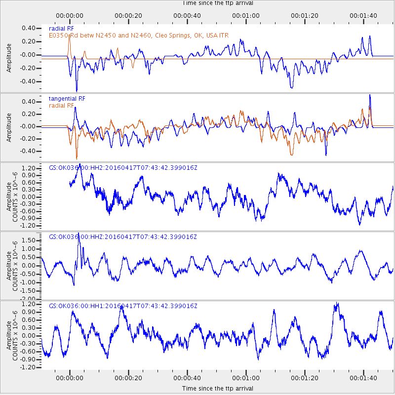
OK036 E0350 Rd betw N2450 and N2460, Cleo Springs, OK, USA - Earthquake Result Viewer
*The percent match for this event was below the threshold and hence no stack was calculated.
| Earthquake location: |
Tonga Islands Region |
| Earthquake latitude/longitude: |
-23.6/-174.3 |
| Earthquake time(UTC): |
2016/04/17 (108) 07:31:03 GMT |
| Earthquake Depth: |
35 km |
| Earthquake Magnitude: |
5.8 MB |
| Earthquake Catalog/Contributor: |
NEIC PDE/NEIC COMCAT |
|
| Network: |
GS US Geological Survey Networks |
| Station: |
OK036 E0350 Rd betw N2450 and N2460, Cleo Springs, OK, USA |
| Lat/Lon: |
36.51 N/98.63 W |
| Elevation: |
460 m |
|
| Distance: |
93.0 deg |
| Az: |
51.427 deg |
| Baz: |
242.893 deg |
| Ray Param: |
$rayparam |
*The percent match for this event was below the threshold and hence was not used in the summary stack. |
|
| Radial Match: |
55.786785 % |
| Radial Bump: |
400 |
| Transverse Match: |
41.33455 % |
| Transverse Bump: |
400 |
| SOD ConfigId: |
1475611 |
| Insert Time: |
2016-05-01 07:36:37.827 +0000 |
| GWidth: |
2.5 |
| Max Bumps: |
400 |
| Tol: |
0.001 |
|
Signal To Noise
| Channel | StoN | STA | LTA |
| GS:OK036:00:HHZ:20160417T07:43:42.399016Z | 2.4474726 | 8.425068E-7 | 3.4423542E-7 |
| GS:OK036:00:HH1:20160417T07:43:42.399016Z | 1.6274371 | 8.2074894E-7 | 5.0431987E-7 |
| GS:OK036:00:HH2:20160417T07:43:42.399016Z | 0.5175458 | 2.5409057E-7 | 4.909528E-7 |
| Arrivals |
| Ps | |
| PpPs | |
| PsPs/PpSs | |


