You are here: Home > Network List > JP - Japan Meteorological Agency Seismic Network Stations List
> Station JEM Erimo > Earthquake Result Viewer
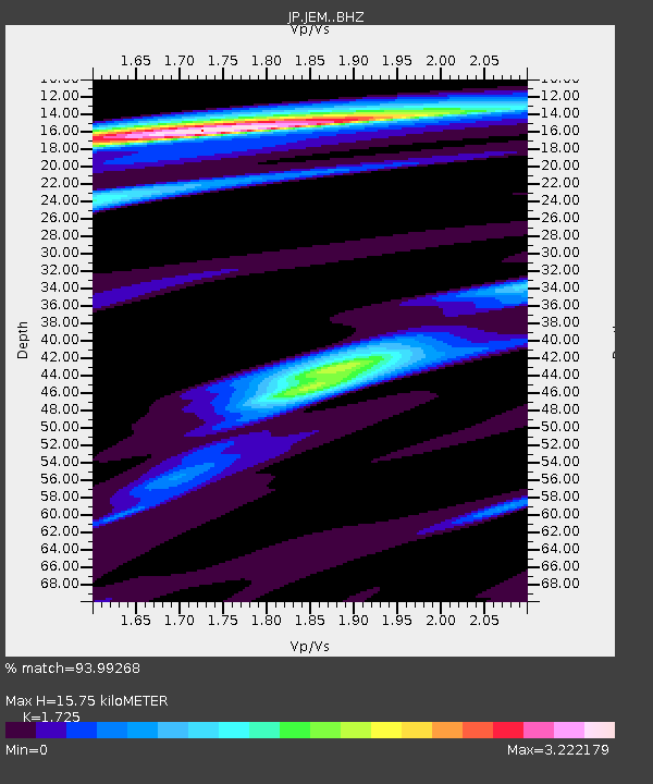
JEM Erimo - Earthquake Result Viewer
| Earthquake location: |
Gulf Of Alaska |
| Earthquake latitude/longitude: |
56.0/-149.1 |
| Earthquake time(UTC): |
2018/01/23 (023) 09:31:42 GMT |
| Earthquake Depth: |
25 km |
| Earthquake Magnitude: |
7.9 Mww |
| Earthquake Catalog/Contributor: |
NEIC PDE/us |
|
| Network: |
JP Japan Meteorological Agency Seismic Network |
| Station: |
JEM Erimo |
| Lat/Lon: |
42.02 N/143.15 E |
| Elevation: |
40 m |
|
| Distance: |
44.8 deg |
| Az: |
281.543 deg |
| Baz: |
47.542 deg |
| Ray Param: |
0.071683586 |
| Estimated Moho Depth: |
15.75 km |
| Estimated Crust Vp/Vs: |
1.73 |
| Assumed Crust Vp: |
6.461 km/s |
| Estimated Crust Vs: |
3.746 km/s |
| Estimated Crust Poisson's Ratio: |
0.25 |
|
| Radial Match: |
93.99268 % |
| Radial Bump: |
400 |
| Transverse Match: |
87.71655 % |
| Transverse Bump: |
400 |
| SOD ConfigId: |
13570011 |
| Insert Time: |
2019-04-29 14:58:26.721 +0000 |
| GWidth: |
2.5 |
| Max Bumps: |
400 |
| Tol: |
0.001 |
|

Signal To Noise
| Channel | StoN | STA | LTA |
| JP:JEM: :BHZ:20180123T09:39:23.499998Z | 5.8268647 | 9.475464E-6 | 1.6261685E-6 |
| JP:JEM: :BHN:20180123T09:39:23.499998Z | 4.380988 | 4.7373483E-6 | 1.0813424E-6 |
| JP:JEM: :BHE:20180123T09:39:23.499998Z | 4.4028 | 5.5467162E-6 | 1.2598156E-6 |
| Arrivals |
| Ps | 1.9 SECOND |
| PpPs | 6.2 SECOND |
| PsPs/PpSs | 8.1 SECOND |


