You are here: Home > Network List > GS - US Geological Survey Networks Stations List
> Station OK036 E0350 Rd betw N2450 and N2460, Cleo Springs, OK, USA > Earthquake Result Viewer
OK036 E0350 Rd betw N2450 and N2460, Cleo Springs, OK, USA - Earthquake Result Viewer
| Earthquake location: |
Near Coast Of Ecuador |
| Earthquake latitude/longitude: |
0.6/-80.3 |
| Earthquake time(UTC): |
2016/04/23 (114) 01:24:34 GMT |
| Earthquake Depth: |
10 km |
| Earthquake Magnitude: |
5.8 MWP |
| Earthquake Catalog/Contributor: |
NEIC PDE/NEIC COMCAT |
|
| Network: |
GS US Geological Survey Networks |
| Station: |
OK036 E0350 Rd betw N2450 and N2460, Cleo Springs, OK, USA |
| Lat/Lon: |
36.51 N/98.63 W |
| Elevation: |
460 m |
|
| Distance: |
39.6 deg |
| Az: |
336.521 deg |
| Baz: |
150.366 deg |
| Ray Param: |
0.07490588 |
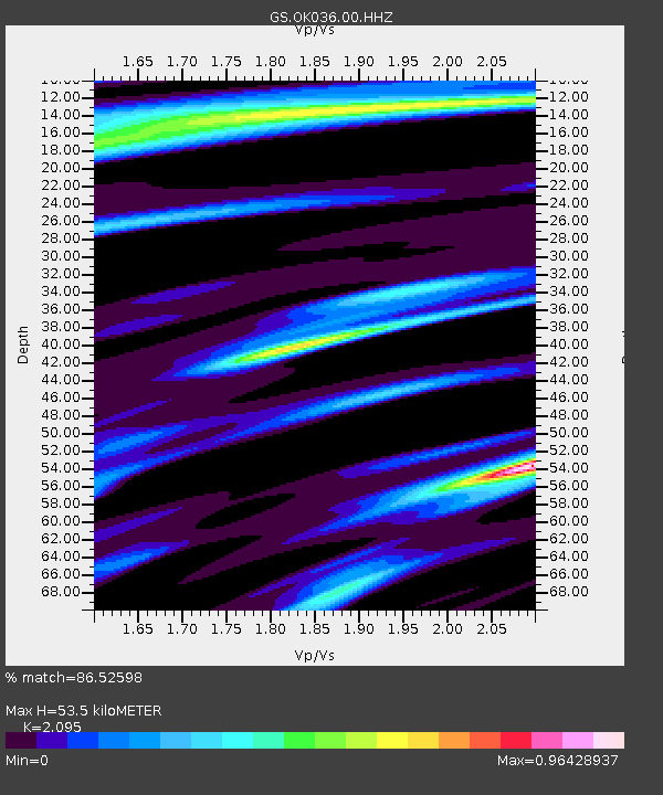
| Estimated Moho Depth: |
53.5 km |
| Estimated Crust Vp/Vs: |
2.10 |
| Assumed Crust Vp: |
6.426 km/s |
| Estimated Crust Vs: |
3.067 km/s |
| Estimated Crust Poisson's Ratio: |
0.35 |
|
| Radial Match: |
86.52598 % |
| Radial Bump: |
259 |
| Transverse Match: |
54.238487 % |
| Transverse Bump: |
400 |
| SOD ConfigId: |
1475611 |
| Insert Time: |
2016-05-07 01:27:09.137 +0000 |
| GWidth: |
2.5 |
| Max Bumps: |
400 |
| Tol: |
0.001 |
|
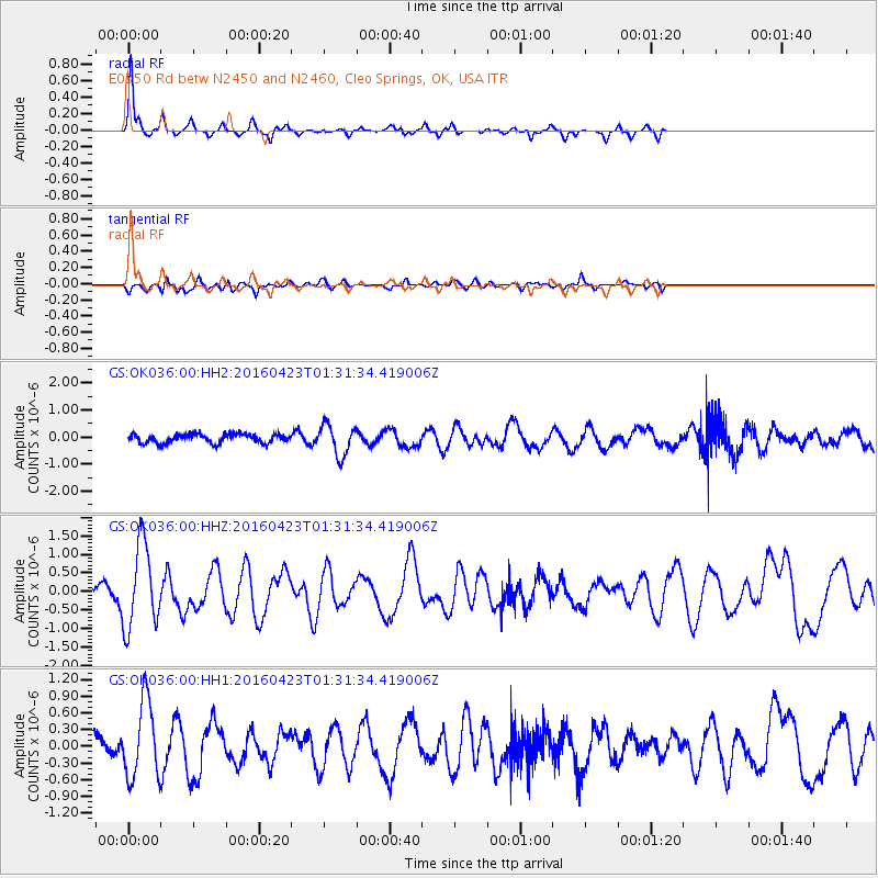
Signal To Noise
| Channel | StoN | STA | LTA |
| GS:OK036:00:HHZ:20160423T01:31:34.419006Z | 4.8132277 | 1.1374887E-6 | 2.3632556E-7 |
| GS:OK036:00:HH1:20160423T01:31:34.419006Z | 2.2872114 | 6.86367E-7 | 3.00089E-7 |
| GS:OK036:00:HH2:20160423T01:31:34.419006Z | 3.3390882 | 5.623245E-7 | 1.684066E-7 |
| Arrivals |
| Ps | 9.7 SECOND |
| PpPs | 24 SECOND |
| PsPs/PpSs | 34 SECOND |


