You are here: Home > Network List > GS - US Geological Survey Networks Stations List
> Station OK040 E2430 and Blaine Rds, Waynoka, OK, USA > Earthquake Result Viewer
OK040 E2430 and Blaine Rds, Waynoka, OK, USA - Earthquake Result Viewer
| Earthquake location: |
Near Coast Of Ecuador |
| Earthquake latitude/longitude: |
0.6/-80.3 |
| Earthquake time(UTC): |
2016/04/23 (114) 01:24:34 GMT |
| Earthquake Depth: |
10 km |
| Earthquake Magnitude: |
5.8 MWP |
| Earthquake Catalog/Contributor: |
NEIC PDE/NEIC COMCAT |
|
| Network: |
GS US Geological Survey Networks |
| Station: |
OK040 E2430 and Blaine Rds, Waynoka, OK, USA |
| Lat/Lon: |
36.48 N/98.67 W |
| Elevation: |
453 m |
|
| Distance: |
39.6 deg |
| Az: |
336.457 deg |
| Baz: |
150.291 deg |
| Ray Param: |
0.074907646 |
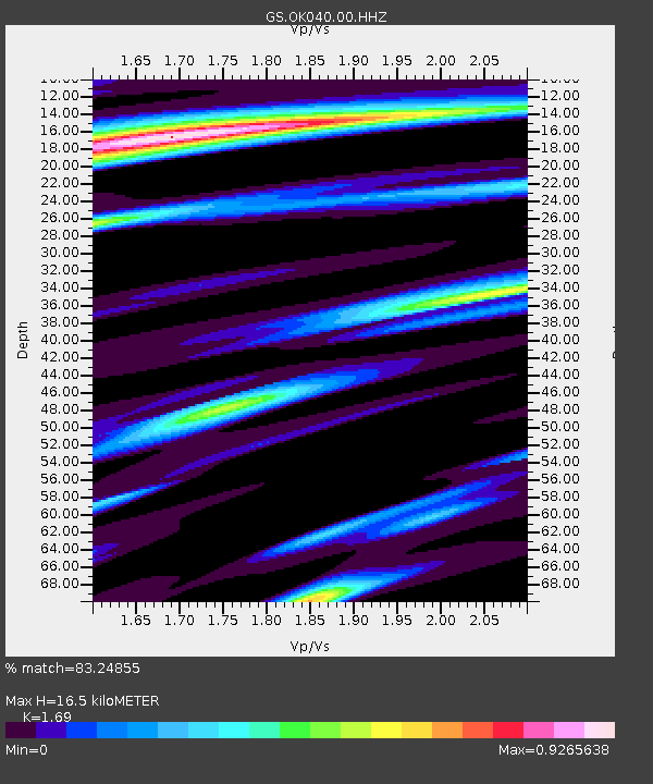
| Estimated Moho Depth: |
16.5 km |
| Estimated Crust Vp/Vs: |
1.69 |
| Assumed Crust Vp: |
6.426 km/s |
| Estimated Crust Vs: |
3.802 km/s |
| Estimated Crust Poisson's Ratio: |
0.23 |
|
| Radial Match: |
83.24855 % |
| Radial Bump: |
259 |
| Transverse Match: |
60.220985 % |
| Transverse Bump: |
400 |
| SOD ConfigId: |
1475611 |
| Insert Time: |
2016-05-07 01:27:22.493 +0000 |
| GWidth: |
2.5 |
| Max Bumps: |
400 |
| Tol: |
0.001 |
|

Signal To Noise
| Channel | StoN | STA | LTA |
| GS:OK040:00:HHZ:20160423T01:31:34.390015Z | 4.9244394 | 1.115074E-6 | 2.2643675E-7 |
| GS:OK040:00:HH1:20160423T01:31:34.390015Z | 1.6280797 | 5.1031407E-7 | 3.134454E-7 |
| GS:OK040:00:HH2:20160423T01:31:34.390015Z | 2.176968 | 6.301596E-7 | 2.894666E-7 |
| Arrivals |
| Ps | 1.9 SECOND |
| PpPs | 6.4 SECOND |
| PsPs/PpSs | 8.3 SECOND |


