
Station GS OK040 - E2430 and Blaine Rds, Waynoka, OK, USA
Network: GS - US Geological Survey Networks
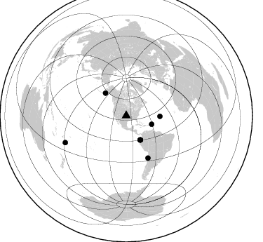
Nearby stations (2 deg radius)
| Station | Name | (Lat, Lon) | Start / End | Elevation |
| OK040 | E2430 and Blaine Rds, Waynoka, OK, USA | (36.48, -98.67) | 2016-02-18 / 2599-12-31 | 453 m |
| Crust2 Type: | D8,thick Platform 3 km seds. |
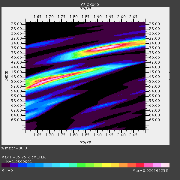
| Thickness Estimate: | 36 km |
| Thickness StdDev: | 6.2 km |
| Vp/Vs Estimate: | 1.93 |
| Vp/Vs StdDev: | 0.13 |
| Vs Estimate: | 3.33 km/s |
| Poisson's Ratio: | 0.32 |
| Peak Value: | 0.02 |
| Assumed Vp: | 6.426 km/s |
| Ps Weight: | 0.33333334 |
| PpPs Weight: | 0.33333334 |
| PsPs Weight: | 0.33333328 |
| Residual Complexity: | 0.768 |
| Nearby stations H: | +- |
| (2.0 deg) Vp/Vs: | +- |
4 with match > 90% ( 30.76923 %) and 9 with match > 80% ( 69.23077 %) out of 13.
Download stack as xyz text file.
Azimuth Distribution of Events:
Prior Results for this Station
| Study | Thickness | Vp/Vs | Vp | Vs | Poissons Ratio | Extra |
| EARS | 36 km | 1.93 | 6.426 km/s | 3.33 km/s | 0.32 | |
| Crust2.0 | 46 km | 1.78 | 6.426 km/s | 3.613 km/s | 0.27 | D8,thick Platform 3 km seds. |
| Global Maxima | 36 km | 1.93 | 6.426 km/s | 3.33 km/s | 0.32 | amp=0.020562256 |
| Local Maxima 1 | 50 km | 1.68 | 6.426 km/s | 3.819 km/s | 0.23 | amp=0.019500984 |
| Local Maxima 2 | 46 km | 1.82 | 6.426 km/s | 3.526 km/s | 0.28 | amp=0.0133499075 |
| Local Maxima 3 | 52 km | 1.62 | 6.426 km/s | 3.973 km/s | 0.19 | amp=0.011042117 |
| Local Maxima 4 | 33 km | 2.09 | 6.426 km/s | 3.082 km/s | 0.35 | amp=0.009111811 |
| Predicted Arrivals for vertical incidence (zero ray parameter) | |
| Ps | 5.17 SECOND |
| PpPs | 16.30 SECOND |
| PsPs/PpSs | 21.47 SECOND |
Events Processed for this Station
Download zip of receiver functions as SAC
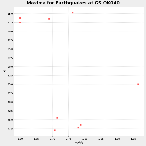
Plot maxima for each earthquake.
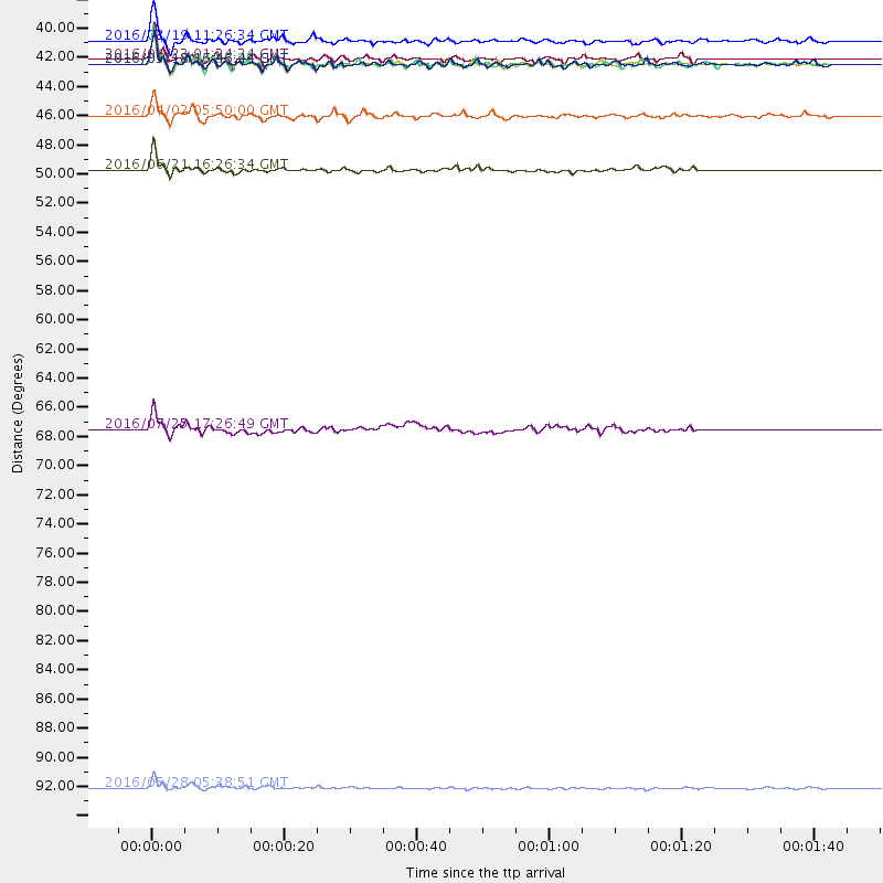
Events Used in the Stack
(9 events)| Radial Match | Distance | Baz | FERegion | Time | Lat/Lon | Depth | Magnitude |
| 96.79994 | 39.9 deg | 149.962 deg | Near Coast Of Ecuador | 2016/04/16 23:58:37 GMT | (0.4, -79.9) | 19 km | 7.8 MWW, 7.4 MI |
| 92.69533 | 39.9 deg | 149.677 deg | Near Coast Of Ecuador | 2016/05/18 07:57:05 GMT | (0.4, -79.8) | 32 km | 6.7 MWP, 6.7 MWW, 6.7 MI |
| 92.50167 | 39.9 deg | 149.477 deg | Near Coast Of Ecuador | 2016/05/18 16:46:44 GMT | (0.5, -79.6) | 31 km | 6.8 MO |
| 90.95097 | 38.2 deg | 108.568 deg | Leeward Islands | 2016/03/19 11:26:34 GMT | (18.0, -60.7) | 32 km | 6.0 MWW, 5.9 MWB |
| 87.71069 | 48.0 deg | 91.25 deg | Northern Mid-Atlantic Ridge | 2016/06/21 16:26:34 GMT | (22.7, -45.1) | 10 km | 6.1 MWB |
| 86.484 | 67.6 deg | 152.813 deg | Near Coast Of Northern Chile | 2016/07/25 17:26:49 GMT | (-26.1, -70.6) | 68 km | 6.2 MB |
| 85.93094 | 43.9 deg | 317.321 deg | Alaska Peninsula | 2016/04/02 05:50:00 GMT | (57.0, -158.0) | 10 km | 6.2 MWP, 6.4 MI |
| 84.173004 | 94.8 deg | 246.29 deg | South Of Fiji Islands | 2016/05/28 05:38:51 GMT | (-22.0, -178.2) | 417 km | 6.6 MO |
| 83.24855 | 39.6 deg | 150.291 deg | Near Coast Of Ecuador | 2016/04/23 01:24:34 GMT | (0.6, -80.3) | 10 km | 5.8 MWP |
Losers
(4 events)| Radial Match | Distance | Baz | FERegion | Time | Lat/Lon | Depth | Magnitude | Reason |
| 59.96764 | 95.7 deg | 247.05 deg | Fiji Islands Region | 2016/02/20 15:51:22 GMT | (-21.9, -179.4) | 579 km | 5.8 MB | |
| 55.50463 | 44.2 deg | 315.002 deg | Alaska Peninsula | 2016/05/31 20:51:22 GMT | (55.4, -158.5) | 39 km | 5.7 MWW, 5.4 MI, 5.7 MWC, 5.8 MB, 5.8 MWB | |
| 49.75357 | 44.7 deg | 109.99 deg | North Atlantic Ocean | 2016/04/20 10:51:39 GMT | (13.2, -55.9) | 10 km | 5.8 MB | |
| 45.303295 | 97.1 deg | 319.841 deg | Kyushu, Japan | 2016/04/15 16:44:06 GMT | (32.7, 130.7) | 10 km | 5.8 MB |

