You are here: Home > Network List > GS - US Geological Survey Networks Stations List
> Station OK041 County Line and E0380 Rds, Cleo Springs, OK, USA > Earthquake Result Viewer
OK041 County Line and E0380 Rds, Cleo Springs, OK, USA - Earthquake Result Viewer
| Earthquake location: |
Near Coast Of Ecuador |
| Earthquake latitude/longitude: |
0.6/-80.3 |
| Earthquake time(UTC): |
2016/04/23 (114) 01:24:34 GMT |
| Earthquake Depth: |
10 km |
| Earthquake Magnitude: |
5.8 MWP |
| Earthquake Catalog/Contributor: |
NEIC PDE/NEIC COMCAT |
|
| Network: |
GS US Geological Survey Networks |
| Station: |
OK041 County Line and E0380 Rds, Cleo Springs, OK, USA |
| Lat/Lon: |
36.47 N/98.53 W |
| Elevation: |
445 m |
|
| Distance: |
39.5 deg |
| Az: |
336.601 deg |
| Baz: |
150.486 deg |
| Ray Param: |
0.07494802 |
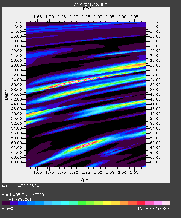
| Estimated Moho Depth: |
35.0 km |
| Estimated Crust Vp/Vs: |
1.79 |
| Assumed Crust Vp: |
6.426 km/s |
| Estimated Crust Vs: |
3.6 km/s |
| Estimated Crust Poisson's Ratio: |
0.27 |
|
| Radial Match: |
80.18524 % |
| Radial Bump: |
400 |
| Transverse Match: |
65.40111 % |
| Transverse Bump: |
400 |
| SOD ConfigId: |
1475611 |
| Insert Time: |
2016-05-07 01:27:28.346 +0000 |
| GWidth: |
2.5 |
| Max Bumps: |
400 |
| Tol: |
0.001 |
|

Signal To Noise
| Channel | StoN | STA | LTA |
| GS:OK041:00:HHZ:20160423T01:31:33.813995Z | 4.9727645 | 9.766064E-7 | 1.9639104E-7 |
| GS:OK041:00:HH1:20160423T01:31:33.813995Z | 2.751907 | 8.2183504E-7 | 2.98642E-7 |
| GS:OK041:00:HH2:20160423T01:31:33.813995Z | 1.7758776 | 5.221746E-7 | 2.940375E-7 |
| Arrivals |
| Ps | 4.6 SECOND |
| PpPs | 14 SECOND |
| PsPs/PpSs | 19 SECOND |


