You are here: Home > Network List > K5 - Bhutan Seismic Network Stations List
> Station MONG Mongar Seismic Station > Earthquake Result Viewer
MONG Mongar Seismic Station - Earthquake Result Viewer
| Earthquake location: |
New Guinea, Papua New Guinea |
| Earthquake latitude/longitude: |
-6.2/142.5 |
| Earthquake time(UTC): |
2018/02/28 (059) 02:45:44 GMT |
| Earthquake Depth: |
10 km |
| Earthquake Magnitude: |
6.0 Mww |
| Earthquake Catalog/Contributor: |
NEIC PDE/us |
|
| Network: |
K5 Bhutan Seismic Network |
| Station: |
MONG Mongar Seismic Station |
| Lat/Lon: |
27.26 N/91.16 E |
| Elevation: |
863 m |
|
| Distance: |
59.7 deg |
| Az: |
306.405 deg |
| Baz: |
115.978 deg |
| Ray Param: |
0.062015582 |
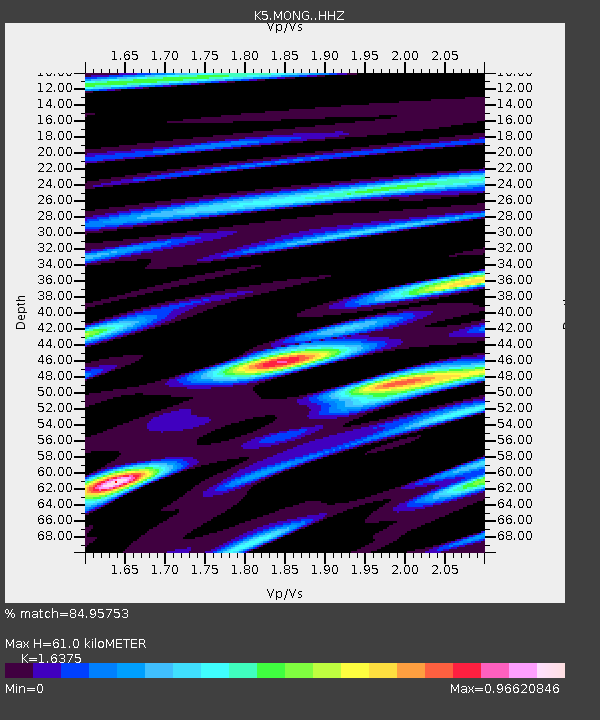
| Estimated Moho Depth: |
61.0 km |
| Estimated Crust Vp/Vs: |
1.64 |
| Assumed Crust Vp: |
6.481 km/s |
| Estimated Crust Vs: |
3.958 km/s |
| Estimated Crust Poisson's Ratio: |
0.20 |
|
| Radial Match: |
84.95753 % |
| Radial Bump: |
400 |
| Transverse Match: |
69.93039 % |
| Transverse Bump: |
400 |
| SOD ConfigId: |
13570011 |
| Insert Time: |
2019-04-29 21:28:39.307 +0000 |
| GWidth: |
2.5 |
| Max Bumps: |
400 |
| Tol: |
0.001 |
|

Signal To Noise
| Channel | StoN | STA | LTA |
| K5:MONG: :HHZ:20180228T02:55:18.009988Z | 5.261072 | 2.858772E-7 | 5.4338205E-8 |
| K5:MONG: :HHN:20180228T02:55:18.009988Z | 1.6176368 | 7.596759E-8 | 4.6962082E-8 |
| K5:MONG: :HHE:20180228T02:55:18.009988Z | 3.6995199 | 1.3723852E-7 | 3.7096303E-8 |
| Arrivals |
| Ps | 6.3 SECOND |
| PpPs | 24 SECOND |
| PsPs/PpSs | 30 SECOND |


