You are here: Home > Network List > GS - US Geological Survey Networks Stations List
> Station OK036 E0350 Rd betw N2450 and N2460, Cleo Springs, OK, USA > Earthquake Result Viewer
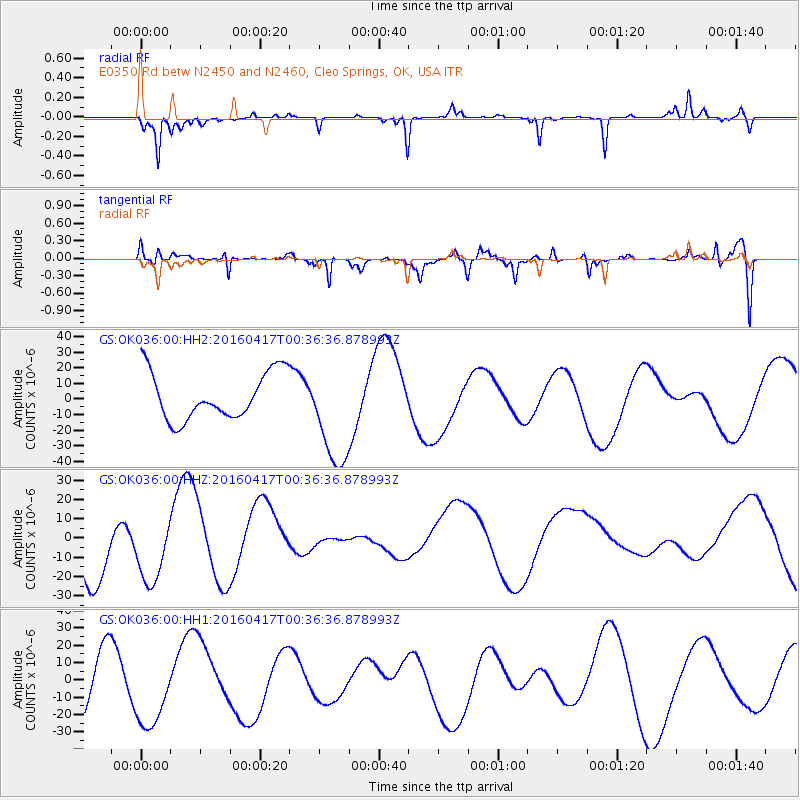
OK036 E0350 Rd betw N2450 and N2460, Cleo Springs, OK, USA - Earthquake Result Viewer
*The percent match for this event was below the threshold and hence no stack was calculated.
| Earthquake location: |
Near Coast Of Ecuador |
| Earthquake latitude/longitude: |
-0.3/-80.5 |
| Earthquake time(UTC): |
2016/04/17 (108) 00:29:31 GMT |
| Earthquake Depth: |
16 km |
| Earthquake Magnitude: |
5.5 MB |
| Earthquake Catalog/Contributor: |
NEIC PDE/NEIC COMCAT |
|
| Network: |
GS US Geological Survey Networks |
| Station: |
OK036 E0350 Rd betw N2450 and N2460, Cleo Springs, OK, USA |
| Lat/Lon: |
36.51 N/98.63 W |
| Elevation: |
460 m |
|
| Distance: |
40.3 deg |
| Az: |
337.139 deg |
| Baz: |
151.172 deg |
| Ray Param: |
$rayparam |
*The percent match for this event was below the threshold and hence was not used in the summary stack. |
|
| Radial Match: |
76.15431 % |
| Radial Bump: |
224 |
| Transverse Match: |
66.22996 % |
| Transverse Bump: |
400 |
| SOD ConfigId: |
1475611 |
| Insert Time: |
2016-05-10 22:06:21.290 +0000 |
| GWidth: |
2.5 |
| Max Bumps: |
400 |
| Tol: |
0.001 |
|
Signal To Noise
| Channel | StoN | STA | LTA |
| GS:OK036:00:HHZ:20160417T00:36:36.878993Z | 0.7706764 | 1.824498E-5 | 2.3673985E-5 |
| GS:OK036:00:HH1:20160417T00:36:36.878993Z | 0.8693812 | 2.2010021E-5 | 2.5316882E-5 |
| GS:OK036:00:HH2:20160417T00:36:36.878993Z | 2.255607 | 3.3878034E-5 | 1.50194755E-5 |
| Arrivals |
| Ps | |
| PpPs | |
| PsPs/PpSs | |


