You are here: Home > Network List > IC - New China Digital Seismograph Network Stations List
> Station HIA Hailar, Neimenggu Autonomous Region, China > Earthquake Result Viewer
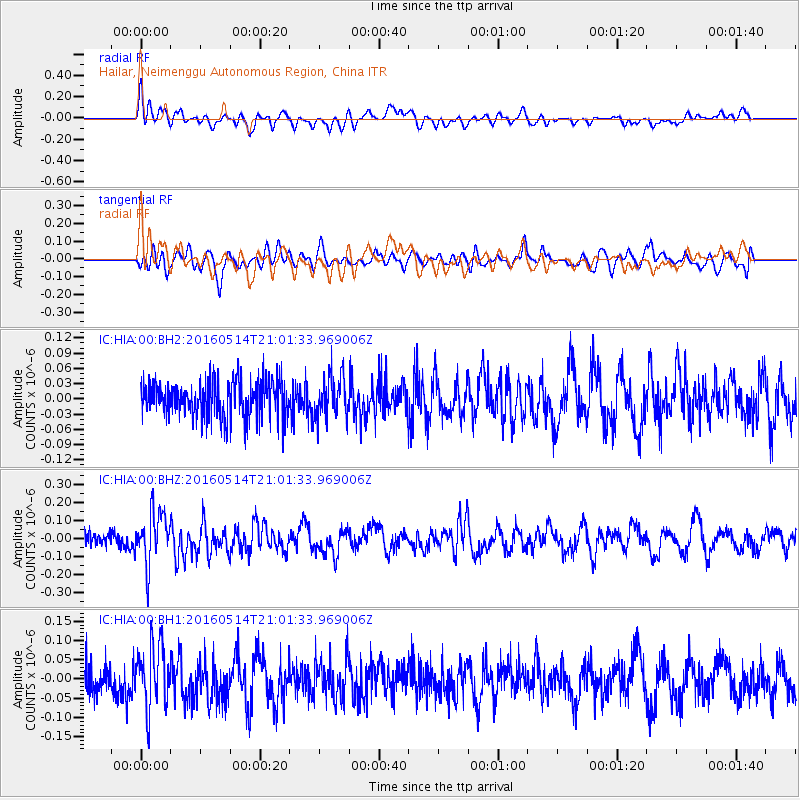
HIA Hailar, Neimenggu Autonomous Region, China - Earthquake Result Viewer
*The percent match for this event was below the threshold and hence no stack was calculated.
| Earthquake location: |
Southwest Of Sumatra, Indonesia |
| Earthquake latitude/longitude: |
-6.9/101.8 |
| Earthquake time(UTC): |
2016/05/14 (135) 20:52:11 GMT |
| Earthquake Depth: |
10 km |
| Earthquake Magnitude: |
5.6 MB, 5.3 MWW |
| Earthquake Catalog/Contributor: |
NEIC PDE/NEIC COMCAT |
|
| Network: |
IC New China Digital Seismograph Network |
| Station: |
HIA Hailar, Neimenggu Autonomous Region, China |
| Lat/Lon: |
49.27 N/119.74 E |
| Elevation: |
620 m |
|
| Distance: |
58.1 deg |
| Az: |
13.763 deg |
| Baz: |
201.14 deg |
| Ray Param: |
$rayparam |
*The percent match for this event was below the threshold and hence was not used in the summary stack. |
|
| Radial Match: |
60.724438 % |
| Radial Bump: |
400 |
| Transverse Match: |
59.006115 % |
| Transverse Bump: |
400 |
| SOD ConfigId: |
1475611 |
| Insert Time: |
2016-05-28 20:53:17.484 +0000 |
| GWidth: |
2.5 |
| Max Bumps: |
400 |
| Tol: |
0.001 |
|
Signal To Noise
| Channel | StoN | STA | LTA |
| IC:HIA:00:BHZ:20160514T21:01:33.969006Z | 2.528133 | 1.4234729E-7 | 5.6305304E-8 |
| IC:HIA:00:BH1:20160514T21:01:33.969006Z | 2.432202 | 8.13833E-8 | 3.3460747E-8 |
| IC:HIA:00:BH2:20160514T21:01:33.969006Z | 1.1816587 | 4.2518405E-8 | 3.5981966E-8 |
| Arrivals |
| Ps | |
| PpPs | |
| PsPs/PpSs | |


