You are here: Home > Network List > XO18 - AACE: Alaska Amphibious Community seismic Experimen Stations List
> Station KD01 Kalsin Bay > Earthquake Result Viewer
KD01 Kalsin Bay - Earthquake Result Viewer
| Earthquake location: |
Vanuatu Islands |
| Earthquake latitude/longitude: |
-17.8/168.0 |
| Earthquake time(UTC): |
2018/06/21 (172) 21:13:32 GMT |
| Earthquake Depth: |
22 km |
| Earthquake Magnitude: |
6.1 Mww |
| Earthquake Catalog/Contributor: |
NEIC PDE/us |
|
| Network: |
XO AACE: Alaska Amphibious Community seismic Experimen |
| Station: |
KD01 Kalsin Bay |
| Lat/Lon: |
57.64 N/152.44 W |
| Elevation: |
80 m |
|
| Distance: |
82.0 deg |
| Az: |
20.225 deg |
| Baz: |
217.761 deg |
| Ray Param: |
0.047149576 |
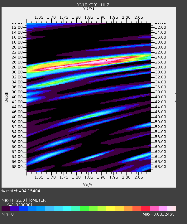
| Estimated Moho Depth: |
25.0 km |
| Estimated Crust Vp/Vs: |
1.92 |
| Assumed Crust Vp: |
6.134 km/s |
| Estimated Crust Vs: |
3.195 km/s |
| Estimated Crust Poisson's Ratio: |
0.31 |
|
| Radial Match: |
84.15484 % |
| Radial Bump: |
400 |
| Transverse Match: |
68.84383 % |
| Transverse Bump: |
400 |
| SOD ConfigId: |
13570011 |
| Insert Time: |
2019-04-30 10:37:18.585 +0000 |
| GWidth: |
2.5 |
| Max Bumps: |
400 |
| Tol: |
0.001 |
|

Signal To Noise
| Channel | StoN | STA | LTA |
| XO:KD01: :HHZ:20180621T21:25:18.719978Z | 10.966317 | 2.1287137E-6 | 1.9411382E-7 |
| XO:KD01: :HHN:20180621T21:25:18.719978Z | 3.4591856 | 7.3956875E-7 | 2.137985E-7 |
| XO:KD01: :HHE:20180621T21:25:18.719978Z | 2.8449047 | 4.870709E-7 | 1.7120816E-7 |
| Arrivals |
| Ps | 3.8 SECOND |
| PpPs | 12 SECOND |
| PsPs/PpSs | 15 SECOND |


