
Station XO KD01 - Kalsin Bay
Network: XO18 - AACE: Alaska Amphibious Community seismic Experimen
Nearby stations (2 deg radius)
| Station | Name | (Lat, Lon) | Start / End | Elevation |
| KD01 | Kalsin Bay | (57.64, -152.44) | 2018-05-23 / 2019-12-31 | 80 m |
| Crust2 Type: | C3,continental shelf, 2 km seds. |
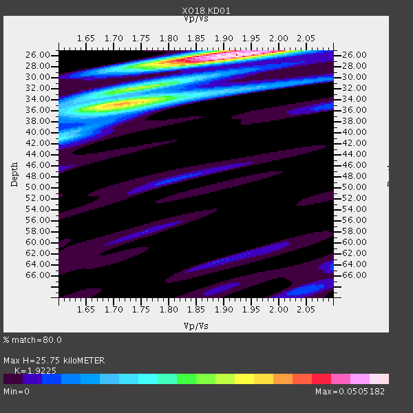
| Thickness Estimate: | 26 km |
| Thickness StdDev: | 3.3 km |
| Vp/Vs Estimate: | 1.92 |
| Vp/Vs StdDev: | 0.07 |
| Vs Estimate: | 3.191 km/s |
| Poisson's Ratio: | 0.31 |
| Peak Value: | 0.05 |
| Assumed Vp: | 6.134 km/s |
| Ps Weight: | 0.33333334 |
| PpPs Weight: | 0.33333334 |
| PsPs Weight: | 0.33333328 |
| Residual Complexity: | 0.619 |
| Nearby stations H: | +- |
| (2.0 deg) Vp/Vs: | +- |
1 with match > 90% ( 2.2222223 %) and 8 with match > 80% ( 17.777779 %) out of 45.
Download stack as xyz text file.
Azimuth Distribution of Events:

Prior Results for this Station
| Study | Thickness | Vp/Vs | Vp | Vs | Poissons Ratio | Extra |
| EARS | 26 km | 1.92 | 6.134 km/s | 3.191 km/s | 0.31 | |
| Crust2.0 | 31 km | 1.80 | 6.134 km/s | 3.406 km/s | 0.28 | C3,continental shelf, 2 km seds. |
| Global Maxima | 26 km | 1.92 | 6.134 km/s | 3.191 km/s | 0.31 | amp=0.0505182 |
| Local Maxima 1 | 34 km | 1.74 | 6.134 km/s | 3.525 km/s | 0.25 | amp=0.03556641 |
| Local Maxima 2 | 25 km | 1.92 | 6.134 km/s | 3.195 km/s | 0.31 | amp=0.019205635 |
| Local Maxima 3 | 35 km | 1.67 | 6.134 km/s | 3.678 km/s | 0.22 | amp=0.01490297 |
| Local Maxima 4 | 32 km | 1.69 | 6.134 km/s | 3.63 km/s | 0.23 | amp=0.010437695 |
| Predicted Arrivals for vertical incidence (zero ray parameter) | |
| Ps | 3.87 SECOND |
| PpPs | 12.27 SECOND |
| PsPs/PpSs | 16.14 SECOND |
Events Processed for this Station
Download zip of receiver functions as SAC
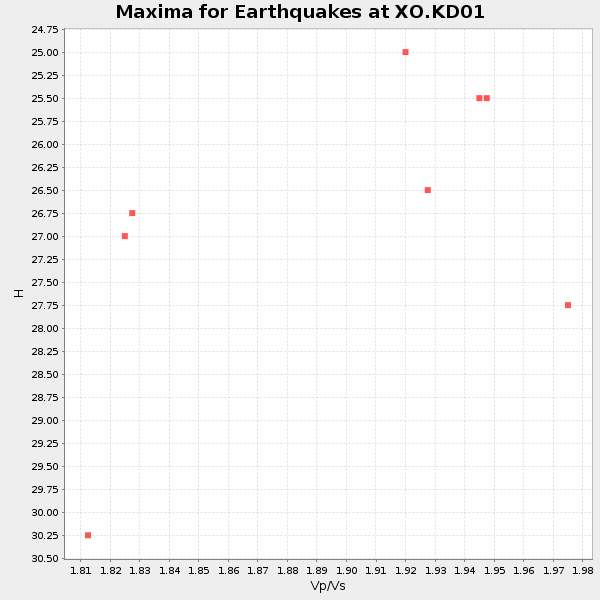
Plot maxima for each earthquake.
Events Used in the Stack
(8 events)| Radial Match | Distance | Baz | FERegion | Time | Lat/Lon | Depth | Magnitude |
| 96.60602 | 78.5 deg | 204.855 deg | Fiji Islands Region | 2018/08/19 00:19:37 GMT | (-18.2, -178.1) | 563 km | 8.2 mww |
| 88.97576 | 56.8 deg | 261.402 deg | Volcano Islands, Japan Region | 2018/08/16 18:21:31 GMT | (23.4, 143.4) | 12 km | 5.8 Mwb |
| 84.92758 | 82.7 deg | 216.479 deg | Vanuatu Islands | 2018/07/13 09:46:49 GMT | (-18.9, 169.0) | 169 km | 6.4 Mww |
| 84.48192 | 85.5 deg | 214.545 deg | Southeast Of Loyalty Islands | 2018/08/29 03:51:55 GMT | (-22.2, 170.0) | 10 km | 7.0 Mi |
| 84.15484 | 82.0 deg | 217.761 deg | Vanuatu Islands | 2018/06/21 21:13:32 GMT | (-17.8, 168.0) | 22 km | 6.1 Mww |
| 84.100395 | 49.0 deg | 272.78 deg | Near East Coast Of Honshu, Japan | 2018/07/07 11:23:49 GMT | (35.1, 140.7) | 39 km | 5.9 Mww |
| 80.71235 | 94.8 deg | 102.929 deg | Peru-Brazil Border Region | 2018/08/24 09:04:06 GMT | (-11.0, -70.8) | 609 km | 7.1 Mww |
| 80.371994 | 71.6 deg | 102.992 deg | Costa Rica | 2018/08/17 23:22:24 GMT | (8.8, -83.2) | 15 km | 6.1 Mww |
Losers
(37 events)| Radial Match | Distance | Baz | FERegion | Time | Lat/Lon | Depth | Magnitude | Reason |
| 92.91031 | 80.7 deg | 84.523 deg | Near Coast Of Venezuela | 2018/08/21 21:31:46 GMT | (10.9, -62.9) | 154 km | 7.3 Mww | |
| 77.12241 | 56.4 deg | 111.18 deg | Oaxaca, Mexico | 2018/07/19 13:31:53 GMT | (17.8, -97.8) | 55 km | 5.7 Mww | |
| 77.11707 | 47.4 deg | 6.833 deg | Greenland Sea | 2018/08/07 13:57:09 GMT | (74.6, 8.4) | 10 km | 5.8 Mww | |
| 75.31261 | 32.3 deg | 276.683 deg | Kuril Islands | 2018/08/10 18:12:05 GMT | (48.5, 154.8) | 16 km | 5.9 Mww | |
| 72.49069 | 81.0 deg | 266.682 deg | Mindanao, Philippines | 2018/07/03 09:59:54 GMT | (5.9, 125.2) | 100 km | 5.6 Mww | |
| 72.05269 | 60.3 deg | 253.704 deg | Mariana Islands Region | 2018/08/28 22:35:14 GMT | (16.8, 147.1) | 53 km | 6.6 Mi | |
| 71.78149 | 45.1 deg | 272.518 deg | Off East Coast Of Honshu, Japan | 2018/08/07 15:12:57 GMT | (37.9, 144.1) | 12 km | 5.6 Mww | |
| 69.216995 | 74.2 deg | 200.79 deg | Samoa Islands Region | 2018/06/02 11:53:06 GMT | (-14.8, -173.1) | 50 km | 5.6 mb | |
| 68.600945 | 77.6 deg | 226.919 deg | Solomon Islands | 2018/06/23 00:33:39 GMT | (-10.3, 161.1) | 23 km | 5.5 Mww | |
| 66.517296 | 38.4 deg | 281.651 deg | Sea Of Okhotsk | 2018/07/01 20:45:42 GMT | (46.9, 145.0) | 388 km | 5.6 Mww | |
| 65.15494 | 51.9 deg | 276.63 deg | Near S. Coast Of Western Honshu | 2018/06/17 22:58:35 GMT | (34.8, 135.6) | 11 km | 5.5 Mww | |
| 61.594902 | 77.3 deg | 205.072 deg | Fiji Islands Region | 2018/08/19 04:28:58 GMT | (-17.0, -178.0) | 416 km | 6.8 mww | |
| 57.77394 | 63.4 deg | 107.501 deg | Near Coast Of Guatemala | 2018/08/09 19:21:53 GMT | (13.6, -91.2) | 29 km | 5.6 Mww | |
| 57.696182 | 78.3 deg | 204.734 deg | Fiji Islands Region | 2018/08/28 13:09:10 GMT | (-18.0, -177.9) | 592 km | 5.7 Mww | |
| 56.52863 | 79.2 deg | 240.023 deg | New Britain Region, P.N.G. | 2018/07/19 18:30:32 GMT | (-6.1, 148.7) | 30 km | 6.0 Mww | |
| 54.76288 | 76.9 deg | 221.516 deg | Santa Cruz Islands | 2018/07/17 07:02:55 GMT | (-11.7, 166.3) | 60 km | 5.9 Mww | |
| 54.577385 | 95.0 deg | 264.131 deg | Flores Sea | 2018/08/17 15:35:02 GMT | (-7.4, 119.8) | 539 km | 6.5 Mww | |
| 54.347588 | 47.6 deg | 273.253 deg | Near East Coast Of Honshu, Japan | 2018/09/04 20:11:19 GMT | (36.4, 141.5) | 39 km | 5.4 Mww | |
| 54.224575 | 78.3 deg | 204.996 deg | Fiji Islands Region | 2018/08/19 00:32:59 GMT | (-17.9, -178.2) | 520 km | 5.7 mb | |
| 53.464233 | 55.0 deg | 267.654 deg | Bonin Islands, Japan Region | 2018/09/01 15:43:02 GMT | (27.9, 139.9) | 455 km | 5.6 Mww | |
| 51.821594 | 80.3 deg | 218.27 deg | Vanuatu Islands | 2018/08/21 22:32:27 GMT | (-16.0, 168.2) | 13 km | 6.5 Mww | |
| 51.089314 | 38.7 deg | 275.781 deg | East Of Kuril Islands | 2018/06/02 09:48:08 GMT | (43.9, 148.0) | 10 km | 5.5 Mww | |
| 48.61866 | 56.7 deg | 261.494 deg | Volcano Islands, Japan Region | 2018/08/17 22:06:57 GMT | (23.5, 143.3) | 18 km | 5.5 Mww | |
| 46.83562 | 75.7 deg | 114.94 deg | Galapagos Islands, Ecuador | 2018/06/26 09:15:36 GMT | (-0.7, -90.9) | 10 km | 5.5 Mww | |
| 46.661564 | 89.8 deg | 201.511 deg | Kermadec Islands, New Zealand | 2018/07/28 09:28:20 GMT | (-30.0, -177.4) | 35 km | 5.6 Mww | |
| 46.431366 | 81.4 deg | 236.456 deg | Eastern New Guinea Reg., P.N.G. | 2018/07/30 07:46:43 GMT | (-9.8, 150.8) | 10 km | 5.4 Mww | |
| 46.13088 | 51.8 deg | 117.756 deg | Near Coast Of Jalisco, Mexico | 2018/06/30 03:56:50 GMT | (19.1, -105.1) | 15 km | 5.9 Mww | |
| 44.162952 | 81.3 deg | 264.738 deg | Talaud Islands, Indonesia | 2018/06/02 16:29:01 GMT | (4.6, 126.7) | 41 km | 5.7 Mww | |
| 43.266403 | 85.8 deg | 4.952 deg | Southern Greece | 2018/06/25 05:14:48 GMT | (36.8, 21.4) | 30 km | 5.5 Mww | |
| 42.90189 | 47.2 deg | 274.217 deg | Near East Coast Of Honshu, Japan | 2018/07/31 08:42:20 GMT | (37.2, 141.2) | 10 km | 5.4 Mww | |
| 40.809505 | 86.8 deg | 344.716 deg | Western Iran | 2018/07/22 10:07:27 GMT | (34.6, 46.2) | 12 km | 5.8 Mww | |
| 36.35004 | 82.8 deg | 216.577 deg | Vanuatu Islands | 2018/07/22 21:21:57 GMT | (-18.9, 168.9) | 100 km | 5.5 Mww | |
| 34.553493 | 59.4 deg | 255.769 deg | Mariana Islands | 2018/07/20 23:56:00 GMT | (18.5, 146.0) | 126 km | 5.6 Mww | |
| 33.87478 | 90.5 deg | 201.86 deg | Kermadec Islands, New Zealand | 2018/07/07 21:33:49 GMT | (-30.6, -178.0) | 34 km | 5.9 Mww | |
| 29.702414 | 80.9 deg | 84.359 deg | Near Coast Of Venezuela | 2018/06/23 01:54:42 GMT | (10.8, -62.6) | 106 km | 5.1 Mww | |
| 26.202017 | 82.7 deg | 216.007 deg | Vanuatu Islands | 2018/07/08 21:04:36 GMT | (-19.0, 169.5) | 259 km | 5.5 Mww | |
| 14.926007 | 78.8 deg | 200.407 deg | Tonga Islands | 2018/06/03 00:48:09 GMT | (-19.4, -173.7) | 10 km | 5.6 mb |

