You are here: Home > Network List > IC - New China Digital Seismograph Network Stations List
> Station HIA Hailar, Neimenggu Autonomous Region, China > Earthquake Result Viewer
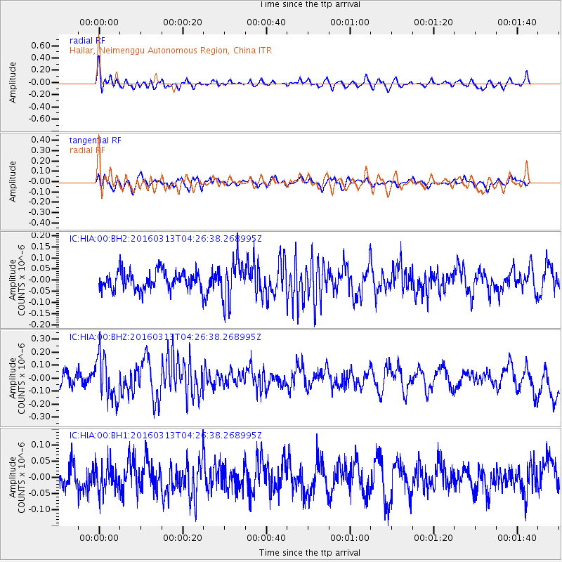
HIA Hailar, Neimenggu Autonomous Region, China - Earthquake Result Viewer
*The percent match for this event was below the threshold and hence no stack was calculated.
| Earthquake location: |
Andreanof Islands, Aleutian Is. |
| Earthquake latitude/longitude: |
51.5/-173.9 |
| Earthquake time(UTC): |
2016/03/13 (073) 04:19:25 GMT |
| Earthquake Depth: |
10 km |
| Earthquake Magnitude: |
5.5 MWC, 4.7 ML, 5.4 MB, 5.5 MWC |
| Earthquake Catalog/Contributor: |
NEIC PDE/NEIC COMCAT |
|
| Network: |
IC New China Digital Seismograph Network |
| Station: |
HIA Hailar, Neimenggu Autonomous Region, China |
| Lat/Lon: |
49.27 N/119.74 E |
| Elevation: |
620 m |
|
| Distance: |
41.1 deg |
| Az: |
293.971 deg |
| Baz: |
60.583 deg |
| Ray Param: |
$rayparam |
*The percent match for this event was below the threshold and hence was not used in the summary stack. |
|
| Radial Match: |
63.535934 % |
| Radial Bump: |
400 |
| Transverse Match: |
43.548645 % |
| Transverse Bump: |
400 |
| SOD ConfigId: |
1609551 |
| Insert Time: |
2016-06-22 14:37:37.831 +0000 |
| GWidth: |
2.5 |
| Max Bumps: |
400 |
| Tol: |
0.001 |
|
Signal To Noise
| Channel | StoN | STA | LTA |
| IC:HIA:00:BHZ:20160313T04:26:38.268995Z | 2.7582178 | 1.6955039E-7 | 6.147099E-8 |
| IC:HIA:00:BH1:20160313T04:26:38.268995Z | 1.0809109 | 4.24361E-8 | 3.9259568E-8 |
| IC:HIA:00:BH2:20160313T04:26:38.268995Z | 2.3297265 | 9.488771E-8 | 4.072912E-8 |
| Arrivals |
| Ps | |
| PpPs | |
| PsPs/PpSs | |


