You are here: Home > Network List > XO18 - AACE: Alaska Amphibious Community seismic Experimen Stations List
> Station ET17 Naknek Lake, AK > Earthquake Result Viewer
ET17 Naknek Lake, AK - Earthquake Result Viewer
| Earthquake location: |
Oaxaca, Mexico |
| Earthquake latitude/longitude: |
17.8/-97.8 |
| Earthquake time(UTC): |
2018/07/19 (200) 13:31:53 GMT |
| Earthquake Depth: |
55 km |
| Earthquake Magnitude: |
5.7 Mww |
| Earthquake Catalog/Contributor: |
NEIC PDE/us |
|
| Network: |
XO AACE: Alaska Amphibious Community seismic Experimen |
| Station: |
ET17 Naknek Lake, AK |
| Lat/Lon: |
58.61 N/156.26 W |
| Elevation: |
53 m |
|
| Distance: |
58.7 deg |
| Az: |
328.515 deg |
| Baz: |
108.084 deg |
| Ray Param: |
0.06254829 |
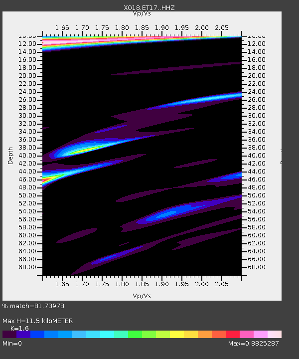
| Estimated Moho Depth: |
11.5 km |
| Estimated Crust Vp/Vs: |
1.60 |
| Assumed Crust Vp: |
6.276 km/s |
| Estimated Crust Vs: |
3.922 km/s |
| Estimated Crust Poisson's Ratio: |
0.18 |
|
| Radial Match: |
81.73978 % |
| Radial Bump: |
400 |
| Transverse Match: |
68.80828 % |
| Transverse Bump: |
400 |
| SOD ConfigId: |
13570011 |
| Insert Time: |
2019-04-30 14:29:34.079 +0000 |
| GWidth: |
2.5 |
| Max Bumps: |
400 |
| Tol: |
0.001 |
|

Signal To Noise
| Channel | StoN | STA | LTA |
| XO:ET17: :HHZ:20180719T13:41:14.968982Z | 17.593767 | 1.5706923E-6 | 8.92755E-8 |
| XO:ET17: :HHN:20180719T13:41:14.968982Z | 2.2863014 | 2.649193E-7 | 1.1587242E-7 |
| XO:ET17: :HHE:20180719T13:41:14.968982Z | 5.339743 | 6.0697175E-7 | 1.13670595E-7 |
| Arrivals |
| Ps | 1.2 SECOND |
| PpPs | 4.5 SECOND |
| PsPs/PpSs | 5.7 SECOND |


