
Station XO ET17 - Naknek Lake, AK
Network: XO18 - AACE: Alaska Amphibious Community seismic Experimen
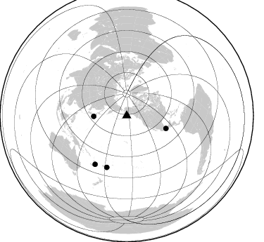
Nearby stations (2 deg radius)
| Station | Name | (Lat, Lon) | Start / End | Elevation |
| ET17 | Naknek Lake, AK | (58.61, -156.26) | 2018-06-08 / 2019-12-31 | 53 m |
| Crust2 Type: | M5,extended crust, 0.5 km seds. |
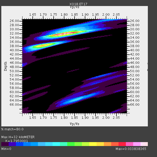
| Thickness Estimate: | 32 km |
| Thickness StdDev: | 9.2 km |
| Vp/Vs Estimate: | 1.80 |
| Vp/Vs StdDev: | 0.06 |
| Vs Estimate: | 3.496 km/s |
| Poisson's Ratio: | 0.27 |
| Peak Value: | 0.03 |
| Assumed Vp: | 6.276 km/s |
| Ps Weight: | 0.33333334 |
| PpPs Weight: | 0.33333334 |
| PsPs Weight: | 0.33333328 |
| Residual Complexity: | 0.427 |
| Nearby stations H: | +- |
| (2.0 deg) Vp/Vs: | +- |
1 with match > 90% ( 2.3255813 %) and 4 with match > 80% ( 9.302325 %) out of 43.
Download stack as xyz text file.
Azimuth Distribution of Events:
Prior Results for this Station
| Study | Thickness | Vp/Vs | Vp | Vs | Poissons Ratio | Extra |
| EARS | 32 km | 1.80 | 6.276 km/s | 3.496 km/s | 0.27 | |
| Crust2.0 | 31 km | 1.78 | 6.276 km/s | 3.529 km/s | 0.27 | M5,extended crust, 0.5 km seds. |
| Global Maxima | 32 km | 1.80 | 6.276 km/s | 3.496 km/s | 0.27 | amp=0.033838365 |
| Local Maxima 1 | 38 km | 1.70 | 6.276 km/s | 3.703 km/s | 0.23 | amp=0.016682263 |
| Local Maxima 2 | 63 km | 1.86 | 6.276 km/s | 3.374 km/s | 0.30 | amp=0.011175548 |
| Local Maxima 3 | 30 km | 1.83 | 6.276 km/s | 3.434 km/s | 0.29 | amp=0.0064139394 |
| Local Maxima 4 | 52 km | 1.97 | 6.276 km/s | 3.194 km/s | 0.33 | amp=0.00532678 |
| Predicted Arrivals for vertical incidence (zero ray parameter) | |
| Ps | 4.05 SECOND |
| PpPs | 14.25 SECOND |
| PsPs/PpSs | 18.31 SECOND |
Events Processed for this Station
Download zip of receiver functions as SAC
Plot maxima for each earthquake.
Events Used in the Stack
(4 events)| Radial Match | Distance | Baz | FERegion | Time | Lat/Lon | Depth | Magnitude |
| 96.13745 | 78.6 deg | 201.155 deg | Fiji Islands Region | 2018/08/19 00:19:37 GMT | (-18.2, -178.1) | 563 km | 8.2 mww |
| 81.73978 | 58.7 deg | 108.084 deg | Oaxaca, Mexico | 2018/07/19 13:31:53 GMT | (17.8, -97.8) | 55 km | 5.7 Mww |
| 81.26268 | 47.0 deg | 268.684 deg | Near East Coast Of Honshu, Japan | 2018/07/07 11:23:49 GMT | (35.1, 140.7) | 39 km | 5.9 Mww |
| 80.268585 | 82.4 deg | 212.944 deg | Vanuatu Islands | 2018/07/13 09:46:49 GMT | (-18.9, 169.0) | 169 km | 6.4 Mww |
Losers
(39 events)| Radial Match | Distance | Baz | FERegion | Time | Lat/Lon | Depth | Magnitude | Reason |
| 84.78711 | 82.6 deg | 81.456 deg | Near Coast Of Venezuela | 2018/08/21 21:31:46 GMT | (10.9, -62.9) | 154 km | 7.3 Mww | |
| 72.343895 | 55.0 deg | 257.347 deg | Volcano Islands, Japan Region | 2018/08/16 18:22:53 GMT | (23.4, 143.3) | 20 km | 6.3 Mww | |
| 67.31229 | 95.6 deg | 263.375 deg | Sumbawa Region, Indonesia | 2018/08/05 11:46:34 GMT | (-8.3, 116.5) | 10 km | 7.0 Mww | |
| 62.281986 | 55.0 deg | 257.255 deg | Volcano Islands, Japan Region | 2018/08/16 18:21:31 GMT | (23.4, 143.4) | 12 km | 5.8 Mwb | |
| 60.372284 | 76.4 deg | 217.752 deg | Santa Cruz Islands | 2018/07/17 07:02:55 GMT | (-11.7, 166.3) | 60 km | 5.9 Mww | |
| 60.029163 | 77.6 deg | 131.552 deg | Central East Pacific Rise | 2018/06/24 18:43:42 GMT | (-9.0, -108.5) | 10 km | 5.7 Mww | |
| 57.802193 | 82.8 deg | 81.631 deg | Near Coast Of Venezuela | 2018/08/22 13:27:47 GMT | (10.6, -62.9) | 98 km | 5.8 Mww | |
| 55.427563 | 65.6 deg | 104.436 deg | Near Coast Of Guatemala | 2018/08/09 19:21:53 GMT | (13.6, -91.2) | 29 km | 5.6 Mww | |
| 53.832993 | 73.8 deg | 99.919 deg | Costa Rica | 2018/08/17 23:22:24 GMT | (8.8, -83.2) | 15 km | 6.1 Mww | |
| 53.595043 | 78.7 deg | 201.201 deg | Fiji Islands Region | 2018/08/20 08:38:00 GMT | (-18.2, -178.2) | 528 km | 5.5 Mww | |
| 53.09991 | 54.0 deg | 114.495 deg | Near Coast Of Jalisco, Mexico | 2018/06/30 03:56:50 GMT | (19.1, -105.1) | 15 km | 5.9 Mww | |
| 53.0059 | 82.4 deg | 213.044 deg | Vanuatu Islands | 2018/07/22 21:21:57 GMT | (-18.9, 168.9) | 100 km | 5.5 Mww | |
| 51.90325 | 93.1 deg | 260.974 deg | Flores Sea | 2018/08/17 15:35:02 GMT | (-7.4, 119.8) | 539 km | 6.5 Mww | |
| 50.333427 | 90.7 deg | 198.639 deg | Kermadec Islands, New Zealand | 2018/07/07 21:33:49 GMT | (-30.6, -178.0) | 34 km | 5.9 Mww | |
| 50.15957 | 79.9 deg | 214.639 deg | Vanuatu Islands | 2018/08/21 22:32:27 GMT | (-16.0, 168.2) | 13 km | 6.5 Mww | |
| 47.20092 | 80.7 deg | 92.19 deg | Northern Colombia | 2018/08/07 15:53:59 GMT | (6.8, -73.0) | 148 km | 5.6 mb | |
| 46.22582 | 85.3 deg | 341.587 deg | Western Iran | 2018/07/22 10:07:27 GMT | (34.6, 46.2) | 12 km | 5.8 Mww | |
| 45.2674 | 57.8 deg | 251.607 deg | Mariana Islands | 2018/07/20 23:56:00 GMT | (18.5, 146.0) | 126 km | 5.6 Mww | |
| 42.62423 | 76.4 deg | 222.779 deg | Solomon Islands | 2018/06/22 19:24:30 GMT | (-10.0, 161.7) | 43 km | 5.4 Mww | |
| 41.934185 | 81.6 deg | 214.198 deg | Vanuatu Islands | 2018/06/21 21:13:32 GMT | (-17.8, 168.0) | 22 km | 6.1 Mww | |
| 39.44447 | 85.5 deg | 250.574 deg | Tanimbar Islands Reg., Indonesia | 2018/08/03 05:42:14 GMT | (-6.2, 132.7) | 28 km | 5.4 Mww | |
| 37.688198 | 77.4 deg | 201.323 deg | Fiji Islands Region | 2018/08/19 04:28:58 GMT | (-17.0, -178.0) | 416 km | 6.8 mww | |
| 37.576103 | 82.8 deg | 81.289 deg | Near Coast Of Venezuela | 2018/06/23 01:54:42 GMT | (10.8, -62.6) | 106 km | 5.1 Mww | |
| 37.321037 | 82.3 deg | 197.354 deg | Tonga Islands Region | 2018/06/21 19:33:08 GMT | (-22.5, -174.9) | 4.8 km | 5.4 mb | |
| 37.09756 | 49.8 deg | 272.732 deg | Near S. Coast Of Western Honshu | 2018/06/17 22:58:35 GMT | (34.8, 135.6) | 11 km | 5.5 Mww | |
| 36.881386 | 45.1 deg | 270.113 deg | Near East Coast Of Honshu, Japan | 2018/07/31 08:42:20 GMT | (37.2, 141.2) | 10 km | 5.4 Mww | |
| 36.298904 | 54.9 deg | 257.346 deg | Volcano Islands, Japan Region | 2018/08/17 22:06:57 GMT | (23.5, 143.3) | 18 km | 5.5 Mww | |
| 35.272198 | 80.4 deg | 232.897 deg | Eastern New Guinea Reg., P.N.G. | 2018/07/30 07:46:43 GMT | (-9.8, 150.8) | 10 km | 5.4 Mww | |
| 35.090218 | 90.0 deg | 198.262 deg | Kermadec Islands, New Zealand | 2018/07/28 09:28:20 GMT | (-30.0, -177.4) | 35 km | 5.6 Mww | |
| 31.554811 | 43.1 deg | 268.286 deg | Off East Coast Of Honshu, Japan | 2018/08/07 15:12:57 GMT | (37.9, 144.1) | 12 km | 5.6 Mww | |
| 30.992052 | 91.4 deg | 258.639 deg | Flores Sea | 2018/07/28 17:07:23 GMT | (-7.1, 122.7) | 577 km | 6.0 Mww | |
| 30.615211 | 78.4 deg | 201.287 deg | Fiji Islands Region | 2018/08/19 00:32:59 GMT | (-17.9, -178.2) | 520 km | 5.7 mb | |
| 30.160078 | 82.4 deg | 212.471 deg | Vanuatu Islands | 2018/07/08 21:04:36 GMT | (-19.0, 169.5) | 259 km | 5.5 Mww | |
| 27.96008 | 78.0 deg | 236.396 deg | New Britain Region, P.N.G. | 2018/07/19 18:30:32 GMT | (-6.1, 148.7) | 30 km | 6.0 Mww | |
| 24.202034 | 54.8 deg | 273.374 deg | Kyushu, Japan | 2018/06/11 19:54:21 GMT | (31.3, 131.5) | 34 km | 5.4 Mww | |
| 23.748327 | 84.0 deg | 201.753 deg | South Of Fiji Islands | 2018/07/12 06:51:21 GMT | (-23.3, -179.9) | 540 km | 5.5 Mww | |
| 21.40732 | 76.8 deg | 223.192 deg | Solomon Islands | 2018/06/23 00:33:39 GMT | (-10.3, 161.1) | 23 km | 5.5 Mww | |
| 18.92419 | 36.2 deg | 277.594 deg | Sea Of Okhotsk | 2018/07/01 20:45:42 GMT | (46.9, 145.0) | 388 km | 5.6 Mww | |
| 11.130449 | 46.6 deg | 5.568 deg | Greenland Sea | 2018/08/07 13:57:09 GMT | (74.6, 8.4) | 10 km | 5.8 Mww |

