You are here: Home > Network List > MC - Montserrat CALIPSO Borehole Network Stations List
> Station TRNT Trants Estate, Montserrat > Earthquake Result Viewer
TRNT Trants Estate, Montserrat - Earthquake Result Viewer
| Earthquake location: |
South Sandwich Islands Region |
| Earthquake latitude/longitude: |
-58.1/-25.3 |
| Earthquake time(UTC): |
2018/08/14 (226) 03:29:53 GMT |
| Earthquake Depth: |
35 km |
| Earthquake Magnitude: |
6.1 Mww |
| Earthquake Catalog/Contributor: |
NEIC PDE/us |
|
| Network: |
MC Montserrat CALIPSO Borehole Network |
| Station: |
TRNT Trants Estate, Montserrat |
| Lat/Lon: |
16.76 N/62.16 W |
| Elevation: |
10 m |
|
| Distance: |
80.6 deg |
| Az: |
324.328 deg |
| Baz: |
161.148 deg |
| Ray Param: |
0.04813377 |
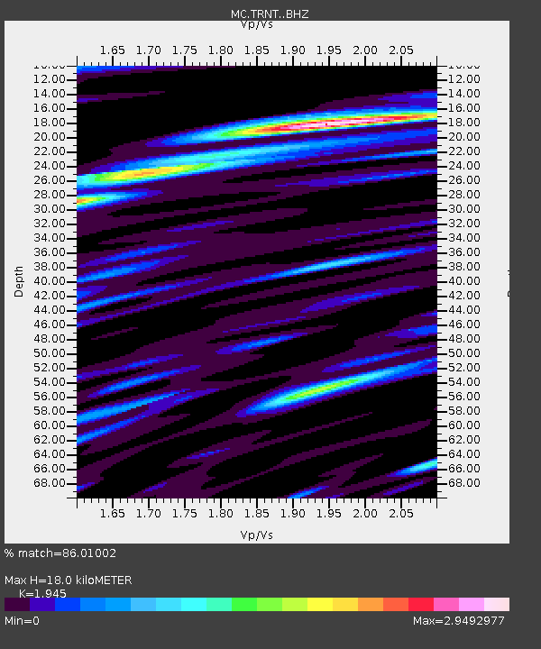
| Estimated Moho Depth: |
18.0 km |
| Estimated Crust Vp/Vs: |
1.95 |
| Assumed Crust Vp: |
6.048 km/s |
| Estimated Crust Vs: |
3.109 km/s |
| Estimated Crust Poisson's Ratio: |
0.32 |
|
| Radial Match: |
86.01002 % |
| Radial Bump: |
400 |
| Transverse Match: |
83.84516 % |
| Transverse Bump: |
400 |
| SOD ConfigId: |
13570011 |
| Insert Time: |
2019-04-30 19:25:39.357 +0000 |
| GWidth: |
2.5 |
| Max Bumps: |
400 |
| Tol: |
0.001 |
|

Signal To Noise
| Channel | StoN | STA | LTA |
| MC:TRNT: :BHZ:20180814T03:41:31.208982Z | 5.0121503 | 0.97980434 | 0.19548582 |
| MC:TRNT: :BHN:20180814T03:41:31.208982Z | 5.6897655 | 0.8780296 | 0.15431736 |
| MC:TRNT: :BHE:20180814T03:41:31.208982Z | 4.1709914 | 0.845458 | 0.20269951 |
| Arrivals |
| Ps | 2.9 SECOND |
| PpPs | 8.6 SECOND |
| PsPs/PpSs | 11 SECOND |


