
Station MC TRNT - Trants Estate, Montserrat
Network: MC - Montserrat CALIPSO Borehole Network
Nearby stations (2 deg radius)
| Station | Name | (Lat, Lon) | Start / End | Elevation |
| TRNT | Trants Estate, Montserrat | (16.76, -62.16) | 2008-01-01 / 2599-12-31 | 10 m |
| Crust2 Type: | S2,continental slope, margin, transition 2 km seds. |
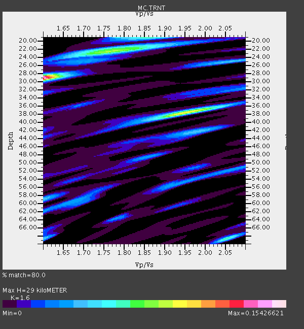
| Thickness Estimate: | 29 km |
| Thickness StdDev: | 7.4 km |
| Vp/Vs Estimate: | 1.60 |
| Vp/Vs StdDev: | 0.11 |
| Vs Estimate: | 3.78 km/s |
| Poisson's Ratio: | 0.18 |
| Peak Value: | 0.15 |
| Assumed Vp: | 6.048 km/s |
| Ps Weight: | 0.33333334 |
| PpPs Weight: | 0.33333334 |
| PsPs Weight: | 0.33333328 |
| Residual Complexity: | 0.870 |
| Nearby stations H: | +- |
| (2.0 deg) Vp/Vs: | +- |
1 with match > 90% ( 4.5454545 %) and 4 with match > 80% ( 18.181818 %) out of 22.
Download stack as xyz text file.
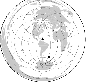
Azimuth Distribution of Events:
Prior Results for this Station
| Study | Thickness | Vp/Vs | Vp | Vs | Poissons Ratio | Extra |
| EARS | 29 km | 1.60 | 6.048 km/s | 3.78 km/s | 0.18 | |
| Crust2.0 | 24 km | 1.81 | 6.048 km/s | 3.34 km/s | 0.28 | S2,continental slope, margin, transition 2 km seds. |
| Global Maxima | 29 km | 1.60 | 6.048 km/s | 3.78 km/s | 0.18 | amp=0.15426621 |
| Local Maxima 1 | 38 km | 1.95 | 6.048 km/s | 3.101 km/s | 0.32 | amp=0.10001276 |
| Local Maxima 2 | 22 km | 1.77 | 6.048 km/s | 3.407 km/s | 0.27 | amp=0.08121389 |
| Local Maxima 3 | 68 km | 2.05 | 6.048 km/s | 2.95 km/s | 0.34 | amp=0.06007308 |
| Local Maxima 4 | 42 km | 1.98 | 6.048 km/s | 3.062 km/s | 0.33 | amp=0.045614008 |
| Predicted Arrivals for vertical incidence (zero ray parameter) | |
| Ps | 2.88 SECOND |
| PpPs | 12.47 SECOND |
| PsPs/PpSs | 15.34 SECOND |
Events Processed for this Station
Download zip of receiver functions as SAC
Plot maxima for each earthquake.
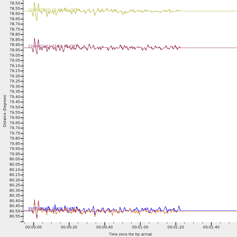
Events Used in the Stack
(4 events)| Radial Match | Distance | Baz | FERegion | Time | Lat/Lon | Depth | Magnitude |
| 95.75364 | 78.5 deg | 160.774 deg | South Sandwich Islands Region | 2016/05/28 09:46:59 GMT | (-56.2, -26.9) | 73 km | 7.2 MWW, 7.3 MI |
| 86.01002 | 80.6 deg | 161.148 deg | South Sandwich Islands Region | 2018/08/14 03:29:53 GMT | (-58.1, -25.3) | 35 km | 6.1 Mww |
| 82.77732 | 78.9 deg | 161.34 deg | South Sandwich Islands Region | 2014/02/01 03:58:43 GMT | (-56.8, -27.3) | 130 km | 6.1 MWW, 6.1 MWC, 6.1 MWB, 6.2 MWC |
| 82.21106 | 80.6 deg | 161.103 deg | South Sandwich Islands Region | 2018/11/01 19:30:20 GMT | (-58.1, -25.2) | 29 km | 5.8 Mww |
Losers
(18 events)| Radial Match | Distance | Baz | FERegion | Time | Lat/Lon | Depth | Magnitude | Reason |
| 95.67032 | 89.3 deg | 324.481 deg | Andreanof Islands, Aleutian Is. | 2015/11/09 16:03:45 GMT | (51.7, -173.1) | 10 km | 6.2 MWB, 6.3 MI | |
| 91.17456 | 79.0 deg | 160.186 deg | South Sandwich Islands Region | 2017/05/10 23:23:39 GMT | (-56.3, -25.5) | 41 km | 6.8 Mi | |
| 86.15954 | 37.4 deg | 193.583 deg | Near Coast Of Northern Chile | 2014/04/02 00:03:12 GMT | (-19.8, -70.9) | 10 km | 5.8 MB | |
| 84.283165 | 67.3 deg | 223.639 deg | Southern East Pacific Rise | 2014/10/09 02:14:32 GMT | (-32.1, -110.8) | 16 km | 7.1 MWW, 6.8 MI | |
| 82.62088 | 30.0 deg | 272.857 deg | Near Coast Of Chiapas, Mexico | 2015/12/17 19:49:54 GMT | (15.9, -93.4) | 97 km | 6.4 MWB, 6.6 MI | |
| 81.35194 | 67.4 deg | 223.708 deg | Southern East Pacific Rise | 2014/10/09 02:32:05 GMT | (-32.1, -110.9) | 10 km | 6.6 MWW, 6.6 MWC | |
| 81.02555 | 74.0 deg | 182.389 deg | Drake Passage | 2018/10/29 06:54:21 GMT | (-57.4, -66.4) | 10 km | 6.3 Mww | |
| 76.0003 | 36.8 deg | 276.741 deg | Guerrero, Mexico | 2014/05/08 17:00:17 GMT | (17.4, -100.7) | 24 km | 6.4 MWW, 6.8 MI | |
| 74.24376 | 34.6 deg | 201.654 deg | Near Coast Of Peru | 2018/01/14 09:18:45 GMT | (-15.8, -74.7) | 36 km | 7.1 mww | |
| 73.17344 | 33.1 deg | 200.524 deg | Central Peru | 2014/08/24 23:21:45 GMT | (-14.6, -73.6) | 101 km | 6.9 MWW, 6.8 MI, 6.9 MWB | |
| 61.94903 | 36.4 deg | 181.781 deg | Southern Bolivia | 2016/01/14 03:25:28 GMT | (-19.8, -63.3) | 582 km | 6.1 MWW, 6.1 MWB | |
| 59.949913 | 80.5 deg | 161.112 deg | South Sandwich Islands Region | 2018/09/03 20:35:51 GMT | (-58.0, -25.3) | 35 km | 5.7 mb | |
| 56.184917 | 87.8 deg | 325.833 deg | Fox Islands, Aleutian Islands | 2014/02/26 21:13:40 GMT | (53.6, -171.8) | 265 km | 6.1 MWW, 5.9 MI, 5.9 ML, 6.1 MWC, 6.1 MWB, 6.2 MWC | |
| 53.146015 | 38.6 deg | 182.069 deg | Salta Province, Argentina | 2012/06/02 07:52:53 GMT | (-22.1, -63.6) | 527 km | 5.8 MB, 5.9 MW, 6.0 MW | |
| 53.06156 | 40.6 deg | 186.182 deg | Jujuy Province, Argentina | 2014/09/24 11:16:12 GMT | (-23.9, -66.6) | 189 km | 6.2 MWP, 6.2 MWB, 6.2 MWC | |
| 51.840813 | 31.3 deg | 275.62 deg | Chiapas, Mexico | 2014/05/21 10:06:14 GMT | (17.2, -94.9) | 128 km | 5.6 MWP | |
| 49.15862 | 66.7 deg | 230.448 deg | Easter Island Region | 2014/07/14 05:44:16 GMT | (-26.7, -114.5) | 15 km | 5.5 MW, 5.4 mB, 5.3 Ms, 5.0 Ms7 | |
| 45.269535 | 37.2 deg | 181.322 deg | Southern Bolivia | 2018/04/02 13:40:34 GMT | (-20.7, -63.0) | 562 km | 6.8 Mww |

