You are here: Home > Network List > XO18 - AACE: Alaska Amphibious Community seismic Experimen Stations List
> Station KD01 Kalsin Bay > Earthquake Result Viewer
KD01 Kalsin Bay - Earthquake Result Viewer
| Earthquake location: |
Fiji Islands Region |
| Earthquake latitude/longitude: |
-18.2/-178.1 |
| Earthquake time(UTC): |
2018/08/19 (231) 00:19:37 GMT |
| Earthquake Depth: |
563 km |
| Earthquake Magnitude: |
8.2 mww |
| Earthquake Catalog/Contributor: |
NEIC PDE/us |
|
| Network: |
XO AACE: Alaska Amphibious Community seismic Experimen |
| Station: |
KD01 Kalsin Bay |
| Lat/Lon: |
57.64 N/152.44 W |
| Elevation: |
80 m |
|
| Distance: |
78.5 deg |
| Az: |
13.755 deg |
| Baz: |
204.855 deg |
| Ray Param: |
0.04786786 |
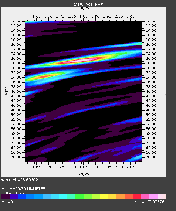
| Estimated Moho Depth: |
26.75 km |
| Estimated Crust Vp/Vs: |
1.83 |
| Assumed Crust Vp: |
6.134 km/s |
| Estimated Crust Vs: |
3.356 km/s |
| Estimated Crust Poisson's Ratio: |
0.29 |
|
| Radial Match: |
96.60602 % |
| Radial Bump: |
329 |
| Transverse Match: |
91.251595 % |
| Transverse Bump: |
400 |
| SOD ConfigId: |
13570011 |
| Insert Time: |
2019-04-30 21:05:06.778 +0000 |
| GWidth: |
2.5 |
| Max Bumps: |
400 |
| Tol: |
0.001 |
|

Signal To Noise
| Channel | StoN | STA | LTA |
| XO:KD01: :HHZ:20180819T00:30:09.470Z | 7.8814673 | 1.0894798E-5 | 1.3823312E-6 |
| XO:KD01: :HHN:20180819T00:30:09.470Z | 2.994534 | 2.46609E-6 | 8.2353046E-7 |
| XO:KD01: :HHE:20180819T00:30:09.470Z | 3.8329492 | 4.2953875E-6 | 1.1206482E-6 |
| Arrivals |
| Ps | 3.7 SECOND |
| PpPs | 12 SECOND |
| PsPs/PpSs | 16 SECOND |


