You are here: Home > Network List > IC - New China Digital Seismograph Network Stations List
> Station HIA Hailar, Neimenggu Autonomous Region, China > Earthquake Result Viewer
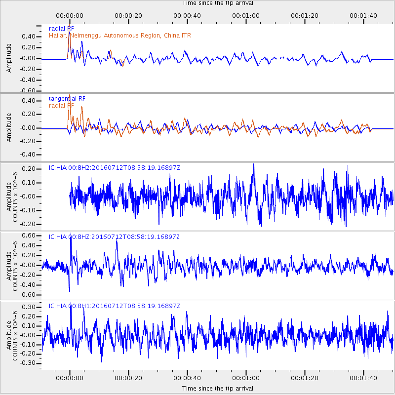
HIA Hailar, Neimenggu Autonomous Region, China - Earthquake Result Viewer
*The percent match for this event was below the threshold and hence no stack was calculated.
| Earthquake location: |
Eastern New Guinea Reg., P.N.G. |
| Earthquake latitude/longitude: |
-6.4/147.5 |
| Earthquake time(UTC): |
2016/07/12 (194) 08:48:44 GMT |
| Earthquake Depth: |
43 km |
| Earthquake Magnitude: |
5.6 MWW, 5.6 MWC |
| Earthquake Catalog/Contributor: |
NEIC PDE/NEIC COMCAT |
|
| Network: |
IC New China Digital Seismograph Network |
| Station: |
HIA Hailar, Neimenggu Autonomous Region, China |
| Lat/Lon: |
49.27 N/119.74 E |
| Elevation: |
620 m |
|
| Distance: |
60.5 deg |
| Az: |
339.514 deg |
| Baz: |
147.928 deg |
| Ray Param: |
$rayparam |
*The percent match for this event was below the threshold and hence was not used in the summary stack. |
|
| Radial Match: |
64.44552 % |
| Radial Bump: |
400 |
| Transverse Match: |
61.696148 % |
| Transverse Bump: |
400 |
| SOD ConfigId: |
1634031 |
| Insert Time: |
2016-07-26 08:50:49.396 +0000 |
| GWidth: |
2.5 |
| Max Bumps: |
400 |
| Tol: |
0.001 |
|
Signal To Noise
| Channel | StoN | STA | LTA |
| IC:HIA:00:BHZ:20160712T08:58:19.16897Z | 3.7149873 | 2.1745328E-7 | 5.8534056E-8 |
| IC:HIA:00:BH1:20160712T08:58:19.16897Z | 2.0604873 | 1.2036979E-7 | 5.8418113E-8 |
| IC:HIA:00:BH2:20160712T08:58:19.16897Z | 1.3002337 | 7.116794E-8 | 5.473473E-8 |
| Arrivals |
| Ps | |
| PpPs | |
| PsPs/PpSs | |


