You are here: Home > Network List > AK - Alaska Regional Network Stations List
> Station BAL Baldy Mountain > Earthquake Result Viewer
BAL Baldy Mountain - Earthquake Result Viewer
| Earthquake location: |
Kuril Islands |
| Earthquake latitude/longitude: |
49.4/156.2 |
| Earthquake time(UTC): |
2018/10/09 (282) 07:45:14 GMT |
| Earthquake Depth: |
42 km |
| Earthquake Magnitude: |
6.0 Mww |
| Earthquake Catalog/Contributor: |
NEIC PDE/us |
|
| Network: |
AK Alaska Regional Network |
| Station: |
BAL Baldy Mountain |
| Lat/Lon: |
61.04 N/142.34 W |
| Elevation: |
1341 m |
|
| Distance: |
35.6 deg |
| Az: |
47.325 deg |
| Baz: |
279.541 deg |
| Ray Param: |
0.0770563 |
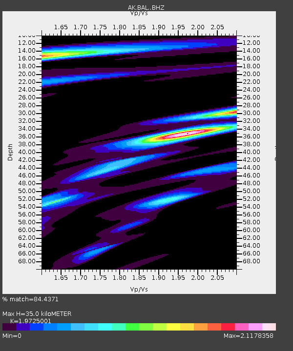
| Estimated Moho Depth: |
35.0 km |
| Estimated Crust Vp/Vs: |
1.97 |
| Assumed Crust Vp: |
6.566 km/s |
| Estimated Crust Vs: |
3.329 km/s |
| Estimated Crust Poisson's Ratio: |
0.33 |
|
| Radial Match: |
84.4371 % |
| Radial Bump: |
400 |
| Transverse Match: |
65.54472 % |
| Transverse Bump: |
400 |
| SOD ConfigId: |
13570011 |
| Insert Time: |
2019-05-01 10:39:17.236 +0000 |
| GWidth: |
2.5 |
| Max Bumps: |
400 |
| Tol: |
0.001 |
|

Signal To Noise
| Channel | StoN | STA | LTA |
| AK:BAL: :BHZ:20181009T07:51:36.927996Z | 3.0346398 | 3.5143242E-7 | 1.15806955E-7 |
| AK:BAL: :BHN:20181009T07:51:36.927996Z | 1.5475224 | 3.342993E-7 | 2.1602227E-7 |
| AK:BAL: :BHE:20181009T07:51:36.927996Z | 1.8301401 | 2.1587881E-7 | 1.1795754E-7 |
| Arrivals |
| Ps | 5.6 SECOND |
| PpPs | 15 SECOND |
| PsPs/PpSs | 20 SECOND |


