You are here: Home > Network List > KR - Kyrgyz Digital Network Stations List
> Station MNAS Manas, Kyrgyzstan > Earthquake Result Viewer
MNAS Manas, Kyrgyzstan - Earthquake Result Viewer
| Earthquake location: |
Mariana Islands Region |
| Earthquake latitude/longitude: |
17.4/147.9 |
| Earthquake time(UTC): |
2018/10/26 (299) 09:05:39 GMT |
| Earthquake Depth: |
10 km |
| Earthquake Magnitude: |
5.7 mww |
| Earthquake Catalog/Contributor: |
NEIC PDE/us |
|
| Network: |
KR Kyrgyz Digital Network |
| Station: |
MNAS Manas, Kyrgyzstan |
| Lat/Lon: |
42.49 N/72.50 E |
| Elevation: |
1465 m |
|
| Distance: |
67.8 deg |
| Az: |
309.369 deg |
| Baz: |
86.45 deg |
| Ray Param: |
0.056730997 |
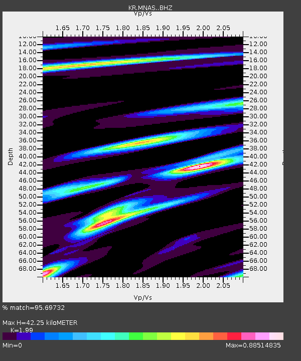
| Estimated Moho Depth: |
42.25 km |
| Estimated Crust Vp/Vs: |
1.99 |
| Assumed Crust Vp: |
6.316 km/s |
| Estimated Crust Vs: |
3.174 km/s |
| Estimated Crust Poisson's Ratio: |
0.33 |
|
| Radial Match: |
95.69732 % |
| Radial Bump: |
260 |
| Transverse Match: |
81.83738 % |
| Transverse Bump: |
400 |
| SOD ConfigId: |
13570011 |
| Insert Time: |
2019-05-01 15:16:14.196 +0000 |
| GWidth: |
2.5 |
| Max Bumps: |
400 |
| Tol: |
0.001 |
|

Signal To Noise
| Channel | StoN | STA | LTA |
| KR:MNAS: :BHZ:20181026T09:16:06.359973Z | 32.64312 | 1.223456E-6 | 3.747975E-8 |
| KR:MNAS: :BHN:20181026T09:16:06.359973Z | 4.0444074 | 1.7075638E-7 | 4.2220375E-8 |
| KR:MNAS: :BHE:20181026T09:16:06.359973Z | 11.097984 | 4.475751E-7 | 4.0329404E-8 |
| Arrivals |
| Ps | 6.8 SECOND |
| PpPs | 19 SECOND |
| PsPs/PpSs | 26 SECOND |


