You are here: Home > Network List > JP - Japan Meteorological Agency Seismic Network Stations List
> Station JEM Erimo > Earthquake Result Viewer
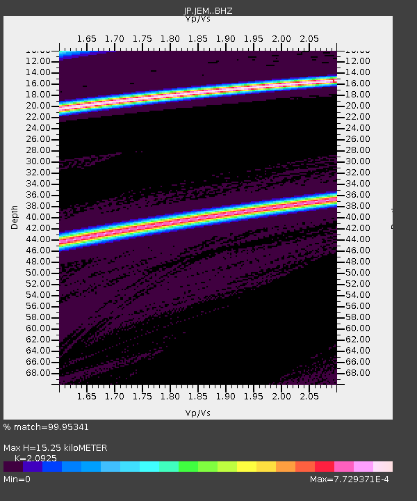
JEM Erimo - Earthquake Result Viewer
| Earthquake location: |
New Britain Region, P.N.G. |
| Earthquake latitude/longitude: |
-6.4/153.4 |
| Earthquake time(UTC): |
2018/11/02 (306) 13:18:45 GMT |
| Earthquake Depth: |
10 km |
| Earthquake Magnitude: |
5.4 Mww |
| Earthquake Catalog/Contributor: |
NEIC PDE/us |
|
| Network: |
JP Japan Meteorological Agency Seismic Network |
| Station: |
JEM Erimo |
| Lat/Lon: |
42.02 N/143.15 E |
| Elevation: |
40 m |
|
| Distance: |
49.1 deg |
| Az: |
349.86 deg |
| Baz: |
166.419 deg |
| Ray Param: |
0.06893793 |
| Estimated Moho Depth: |
15.25 km |
| Estimated Crust Vp/Vs: |
2.09 |
| Assumed Crust Vp: |
6.461 km/s |
| Estimated Crust Vs: |
3.088 km/s |
| Estimated Crust Poisson's Ratio: |
0.35 |
|
| Radial Match: |
99.95341 % |
| Radial Bump: |
9 |
| Transverse Match: |
99.99939 % |
| Transverse Bump: |
2 |
| SOD ConfigId: |
13570011 |
| Insert Time: |
2019-05-01 17:46:25.823 +0000 |
| GWidth: |
2.5 |
| Max Bumps: |
400 |
| Tol: |
0.001 |
|

Signal To Noise
| Channel | StoN | STA | LTA |
| JP:JEM: :BHZ:20181102T13:27:17.900Z | 2.4999049 | 1.1534687E-5 | 4.61405E-6 |
| JP:JEM: :BHN:20181102T13:27:17.900Z | 2.9449642 | 3.9868244E-8 | 1.3537768E-8 |
| JP:JEM: :BHE:20181102T13:27:17.900Z | 2.4947095 | 1.6212596E-5 | 6.4987908E-6 |
| Arrivals |
| Ps | 2.7 SECOND |
| PpPs | 6.9 SECOND |
| PsPs/PpSs | 9.7 SECOND |


