You are here: Home > Network List > TA - USArray Transportable Network (new EarthScope stations) Stations List
> Station P08A Dixie Valley, NV, USA > Earthquake Result Viewer
P08A Dixie Valley, NV, USA - Earthquake Result Viewer
| Earthquake location: |
Peru-Ecuador Border Region |
| Earthquake latitude/longitude: |
-2.3/-77.8 |
| Earthquake time(UTC): |
2007/11/16 (320) 03:13:00 GMT |
| Earthquake Depth: |
123 km |
| Earthquake Magnitude: |
6.3 MB, 6.8 MW, 6.7 MW |
| Earthquake Catalog/Contributor: |
WHDF/NEIC |
|
| Network: |
TA USArray Transportable Network (new EarthScope stations) |
| Station: |
P08A Dixie Valley, NV, USA |
| Lat/Lon: |
39.69 N/118.08 W |
| Elevation: |
1040 m |
|
| Distance: |
55.7 deg |
| Az: |
322.908 deg |
| Baz: |
128.645 deg |
| Ray Param: |
0.0642139 |
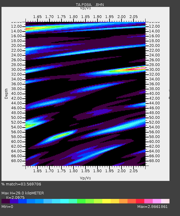
| Estimated Moho Depth: |
29.0 km |
| Estimated Crust Vp/Vs: |
2.10 |
| Assumed Crust Vp: |
6.279 km/s |
| Estimated Crust Vs: |
2.993 km/s |
| Estimated Crust Poisson's Ratio: |
0.35 |
|
| Radial Match: |
83.569786 % |
| Radial Bump: |
400 |
| Transverse Match: |
73.698975 % |
| Transverse Bump: |
400 |
| SOD ConfigId: |
2564 |
| Insert Time: |
2010-03-06 18:20:07.548 +0000 |
| GWidth: |
2.5 |
| Max Bumps: |
400 |
| Tol: |
0.001 |
|

Signal To Noise
| Channel | StoN | STA | LTA |
| TA:P08A: :BHN:20071116T03:21:53.375005Z | 1.4361979 | 1.3086647E-6 | 9.112008E-7 |
| TA:P08A: :BHE:20071116T03:21:53.375005Z | 1.1493754 | 2.0209395E-6 | 1.7582935E-6 |
| TA:P08A: :BHZ:20071116T03:21:53.375005Z | 8.927728 | 2.581691E-6 | 2.8917674E-7 |
| Arrivals |
| Ps | 5.3 SECOND |
| PpPs | 14 SECOND |
| PsPs/PpSs | 19 SECOND |


