You are here: Home > Network List > TA - USArray Transportable Network (new EarthScope stations) Stations List
> Station P08A Dixie Valley, NV, USA > Earthquake Result Viewer
P08A Dixie Valley, NV, USA - Earthquake Result Viewer
| Earthquake location: |
Santa Cruz Islands |
| Earthquake latitude/longitude: |
-11.6/165.8 |
| Earthquake time(UTC): |
2007/09/02 (245) 01:05:18 GMT |
| Earthquake Depth: |
35 km |
| Earthquake Magnitude: |
5.9 MB, 7.3 MS, 7.2 MW, 6.9 ME |
| Earthquake Catalog/Contributor: |
WHDF/NEIC |
|
| Network: |
TA USArray Transportable Network (new EarthScope stations) |
| Station: |
P08A Dixie Valley, NV, USA |
| Lat/Lon: |
39.69 N/118.08 W |
| Elevation: |
1040 m |
|
| Distance: |
86.9 deg |
| Az: |
48.611 deg |
| Baz: |
252.312 deg |
| Ray Param: |
0.043650214 |
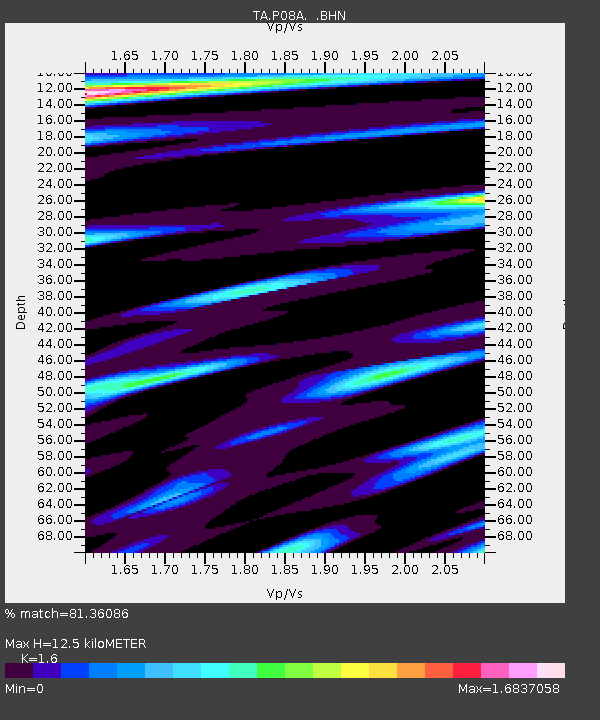
| Estimated Moho Depth: |
12.5 km |
| Estimated Crust Vp/Vs: |
1.60 |
| Assumed Crust Vp: |
6.279 km/s |
| Estimated Crust Vs: |
3.924 km/s |
| Estimated Crust Poisson's Ratio: |
0.18 |
|
| Radial Match: |
81.36086 % |
| Radial Bump: |
400 |
| Transverse Match: |
71.41701 % |
| Transverse Bump: |
400 |
| SOD ConfigId: |
2564 |
| Insert Time: |
2010-03-06 18:20:08.773 +0000 |
| GWidth: |
2.5 |
| Max Bumps: |
400 |
| Tol: |
0.001 |
|

Signal To Noise
| Channel | StoN | STA | LTA |
| TA:P08A: :BHN:20070902T01:17:28.248022Z | 1.0060478 | 6.3809904E-7 | 6.3426313E-7 |
| TA:P08A: :BHE:20070902T01:17:28.248022Z | 3.8633432 | 1.417806E-6 | 3.6698938E-7 |
| TA:P08A: :BHZ:20070902T01:17:28.248022Z | 11.908484 | 2.7915612E-6 | 2.3441785E-7 |
| Arrivals |
| Ps | 1.2 SECOND |
| PpPs | 5.1 SECOND |
| PsPs/PpSs | 6.3 SECOND |


