You are here: Home > Network List > IC - New China Digital Seismograph Network Stations List
> Station HIA Hailar, Neimenggu Autonomous Region, China > Earthquake Result Viewer
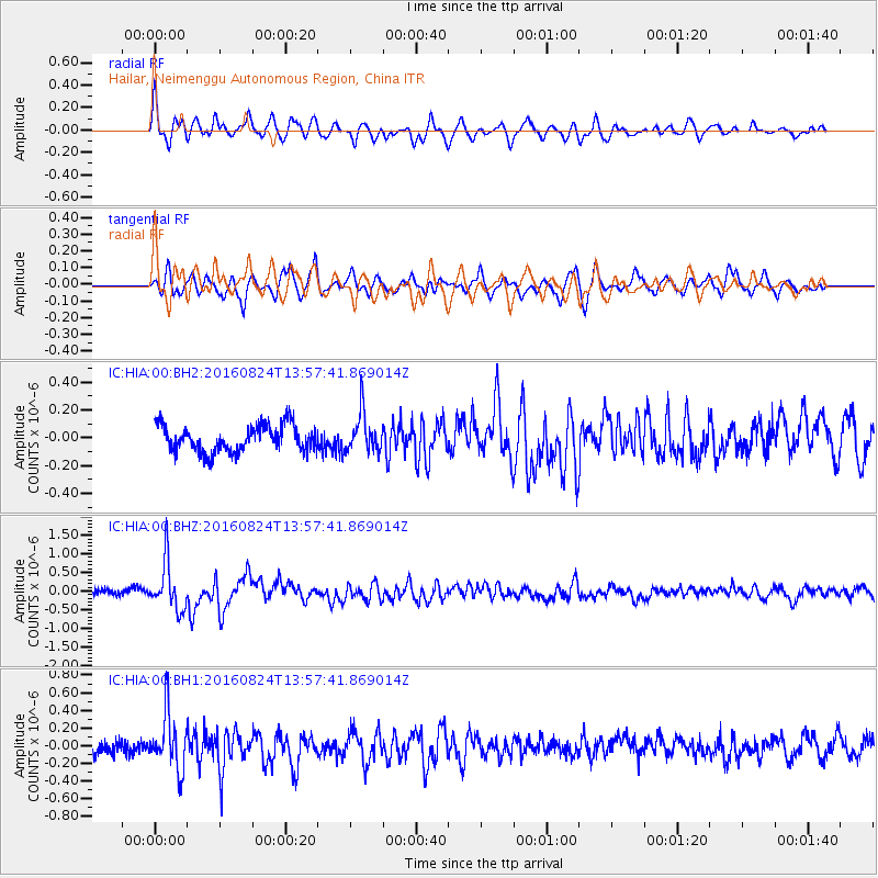
HIA Hailar, Neimenggu Autonomous Region, China - Earthquake Result Viewer
*The percent match for this event was below the threshold and hence no stack was calculated.
| Earthquake location: |
Southern Sumatra, Indonesia |
| Earthquake latitude/longitude: |
-3.0/100.1 |
| Earthquake time(UTC): |
2016/08/24 (237) 13:48:44 GMT |
| Earthquake Depth: |
17 km |
| Earthquake Magnitude: |
5.8 MB |
| Earthquake Catalog/Contributor: |
NEIC PDE/NEIC COMCAT |
|
| Network: |
IC New China Digital Seismograph Network |
| Station: |
HIA Hailar, Neimenggu Autonomous Region, China |
| Lat/Lon: |
49.27 N/119.74 E |
| Elevation: |
620 m |
|
| Distance: |
54.7 deg |
| Az: |
15.677 deg |
| Baz: |
204.33 deg |
| Ray Param: |
$rayparam |
*The percent match for this event was below the threshold and hence was not used in the summary stack. |
|
| Radial Match: |
72.96198 % |
| Radial Bump: |
400 |
| Transverse Match: |
68.937706 % |
| Transverse Bump: |
400 |
| SOD ConfigId: |
1634031 |
| Insert Time: |
2016-09-07 13:49:41.223 +0000 |
| GWidth: |
2.5 |
| Max Bumps: |
400 |
| Tol: |
0.001 |
|
Signal To Noise
| Channel | StoN | STA | LTA |
| IC:HIA:00:BHZ:20160824T13:57:41.869014Z | 8.461014 | 6.252305E-7 | 7.389546E-8 |
| IC:HIA:00:BH1:20160824T13:57:41.869014Z | 4.484052 | 3.1566003E-7 | 7.0396155E-8 |
| IC:HIA:00:BH2:20160824T13:57:41.869014Z | 1.4446119 | 1.3797187E-7 | 9.550791E-8 |
| Arrivals |
| Ps | |
| PpPs | |
| PsPs/PpSs | |


