You are here: Home > Network List > GS - US Geological Survey Networks Stations List
> Station OK047 Pawnee, OK, Station 47 > Earthquake Result Viewer
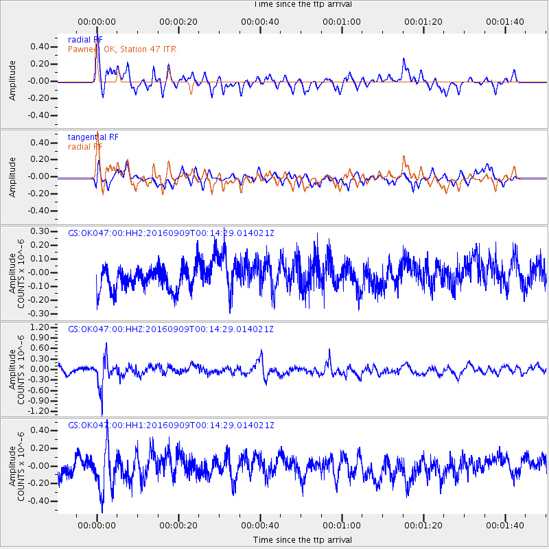
OK047 Pawnee, OK, Station 47 - Earthquake Result Viewer
*The percent match for this event was below the threshold and hence no stack was calculated.
| Earthquake location: |
Cordoba Province, Argentina |
| Earthquake latitude/longitude: |
-31.4/-65.7 |
| Earthquake time(UTC): |
2016/09/09 (253) 00:03:43 GMT |
| Earthquake Depth: |
151 km |
| Earthquake Magnitude: |
5.6 MWR |
| Earthquake Catalog/Contributor: |
NEIC PDE/NEIC COMCAT |
|
| Network: |
GS US Geological Survey Networks |
| Station: |
OK047 Pawnee, OK, Station 47 |
| Lat/Lon: |
36.47 N/96.72 W |
| Elevation: |
253 m |
|
| Distance: |
73.5 deg |
| Az: |
334.36 deg |
| Baz: |
152.678 deg |
| Ray Param: |
$rayparam |
*The percent match for this event was below the threshold and hence was not used in the summary stack. |
|
| Radial Match: |
61.762802 % |
| Radial Bump: |
301 |
| Transverse Match: |
55.04154 % |
| Transverse Bump: |
400 |
| SOD ConfigId: |
1634031 |
| Insert Time: |
2016-09-23 00:09:08.979 +0000 |
| GWidth: |
2.5 |
| Max Bumps: |
400 |
| Tol: |
0.001 |
|
Signal To Noise
| Channel | StoN | STA | LTA |
| GS:OK047:00:HHZ:20160909T00:14:29.014021Z | 5.130948 | 3.9922293E-7 | 7.780685E-8 |
| GS:OK047:00:HH1:20160909T00:14:29.014021Z | 2.3697815 | 2.477601E-7 | 1.0454976E-7 |
| GS:OK047:00:HH2:20160909T00:14:29.014021Z | 1.9645355 | 1.5719701E-7 | 8.0017394E-8 |
| Arrivals |
| Ps | |
| PpPs | |
| PsPs/PpSs | |


