You are here: Home > Network List > JP - Japan Meteorological Agency Seismic Network Stations List
> Station JEM Erimo > Earthquake Result Viewer
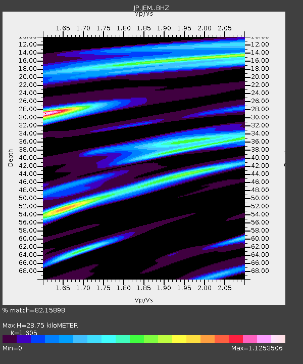
JEM Erimo - Earthquake Result Viewer
| Earthquake location: |
Sumba Region, Indonesia |
| Earthquake latitude/longitude: |
-10.5/119.0 |
| Earthquake time(UTC): |
2019/01/22 (022) 05:10:03 GMT |
| Earthquake Depth: |
27 km |
| Earthquake Magnitude: |
6.4 Mww |
| Earthquake Catalog/Contributor: |
NEIC PDE/us |
|
| Network: |
JP Japan Meteorological Agency Seismic Network |
| Station: |
JEM Erimo |
| Lat/Lon: |
42.02 N/143.15 E |
| Elevation: |
40 m |
|
| Distance: |
56.7 deg |
| Az: |
21.36 deg |
| Baz: |
208.736 deg |
| Ray Param: |
0.06390688 |
| Estimated Moho Depth: |
28.75 km |
| Estimated Crust Vp/Vs: |
1.61 |
| Assumed Crust Vp: |
6.461 km/s |
| Estimated Crust Vs: |
4.026 km/s |
| Estimated Crust Poisson's Ratio: |
0.18 |
|
| Radial Match: |
82.15898 % |
| Radial Bump: |
400 |
| Transverse Match: |
74.2608 % |
| Transverse Bump: |
400 |
| SOD ConfigId: |
13570011 |
| Insert Time: |
2019-05-02 08:56:19.632 +0000 |
| GWidth: |
2.5 |
| Max Bumps: |
400 |
| Tol: |
0.001 |
|

Signal To Noise
| Channel | StoN | STA | LTA |
| JP:JEM: :BHZ:20190122T05:19:25.800005Z | 5.7149024 | 2.6248813E-6 | 4.5930463E-7 |
| JP:JEM: :BHN:20190122T05:19:25.800005Z | 1.1515924 | 8.2785755E-7 | 7.188807E-7 |
| JP:JEM: :BHE:20190122T05:19:25.800005Z | 1.7354236 | 8.630014E-7 | 4.972857E-7 |
| Arrivals |
| Ps | 2.8 SECOND |
| PpPs | 11 SECOND |
| PsPs/PpSs | 14 SECOND |


