You are here: Home > Network List > GS - US Geological Survey Networks Stations List
> Station OK047 Pawnee, OK, Station 47 > Earthquake Result Viewer
OK047 Pawnee, OK, Station 47 - Earthquake Result Viewer
| Earthquake location: |
Northern Peru |
| Earthquake latitude/longitude: |
-5.6/-77.0 |
| Earthquake time(UTC): |
2016/09/10 (254) 10:08:20 GMT |
| Earthquake Depth: |
114 km |
| Earthquake Magnitude: |
6.0 MB |
| Earthquake Catalog/Contributor: |
NEIC PDE/NEIC ALERT |
|
| Network: |
GS US Geological Survey Networks |
| Station: |
OK047 Pawnee, OK, Station 47 |
| Lat/Lon: |
36.47 N/96.72 W |
| Elevation: |
253 m |
|
| Distance: |
45.7 deg |
| Az: |
337.637 deg |
| Baz: |
151.978 deg |
| Ray Param: |
0.07069116 |
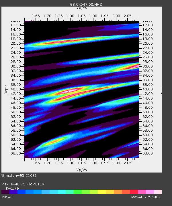
| Estimated Moho Depth: |
40.75 km |
| Estimated Crust Vp/Vs: |
1.79 |
| Assumed Crust Vp: |
6.483 km/s |
| Estimated Crust Vs: |
3.622 km/s |
| Estimated Crust Poisson's Ratio: |
0.27 |
|
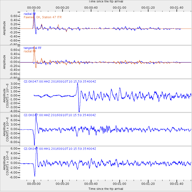
| Radial Match: |
95.21081 % |
| Radial Bump: |
312 |
| Transverse Match: |
79.03096 % |
| Transverse Bump: |
400 |
| SOD ConfigId: |
1634031 |
| Insert Time: |
2016-09-24 10:12:06.517 +0000 |
| GWidth: |
2.5 |
| Max Bumps: |
400 |
| Tol: |
0.001 |
|
Signal To Noise
| Channel | StoN | STA | LTA |
| GS:OK047:00:HHZ:20160910T10:15:59.354004Z | 65.227196 | 4.9149317E-6 | 7.5350954E-8 |
| GS:OK047:00:HH1:20160910T10:15:59.354004Z | 32.853252 | 3.0363194E-6 | 9.242067E-8 |
| GS:OK047:00:HH2:20160910T10:15:59.354004Z | 12.725168 | 1.8987112E-6 | 1.4920911E-7 |
| Arrivals |
| Ps | 5.3 SECOND |
| PpPs | 16 SECOND |
| PsPs/PpSs | 22 SECOND |


