You are here: Home > Network List > GS - US Geological Survey Networks Stations List
> Station OK047 Pawnee, OK, Station 47 > Earthquake Result Viewer
OK047 Pawnee, OK, Station 47 - Earthquake Result Viewer
| Earthquake location: |
Northern Colombia |
| Earthquake latitude/longitude: |
7.3/-76.1 |
| Earthquake time(UTC): |
2016/09/14 (258) 01:58:30 GMT |
| Earthquake Depth: |
10 km |
| Earthquake Magnitude: |
5.9 MWP |
| Earthquake Catalog/Contributor: |
NEIC PDE/NEIC COMCAT |
|
| Network: |
GS US Geological Survey Networks |
| Station: |
OK047 Pawnee, OK, Station 47 |
| Lat/Lon: |
36.47 N/96.72 W |
| Elevation: |
253 m |
|
| Distance: |
34.6 deg |
| Az: |
329.984 deg |
| Baz: |
142.005 deg |
| Ray Param: |
0.07766773 |
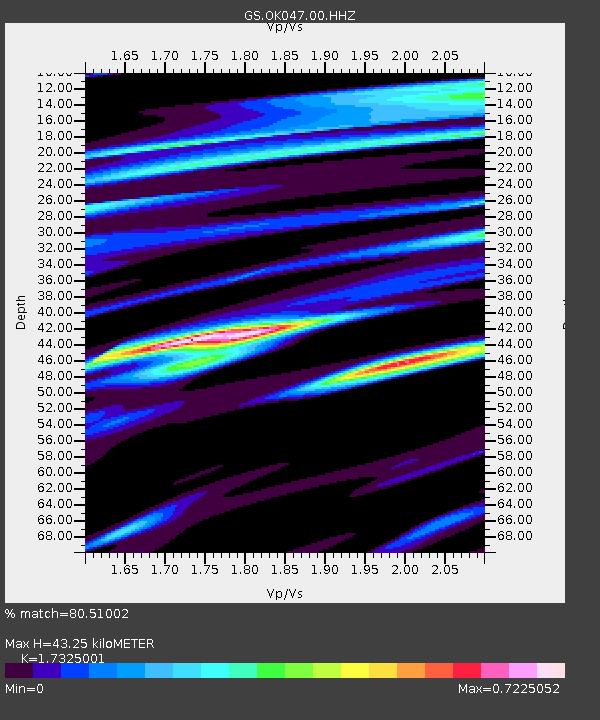
| Estimated Moho Depth: |
43.25 km |
| Estimated Crust Vp/Vs: |
1.73 |
| Assumed Crust Vp: |
6.483 km/s |
| Estimated Crust Vs: |
3.742 km/s |
| Estimated Crust Poisson's Ratio: |
0.25 |
|
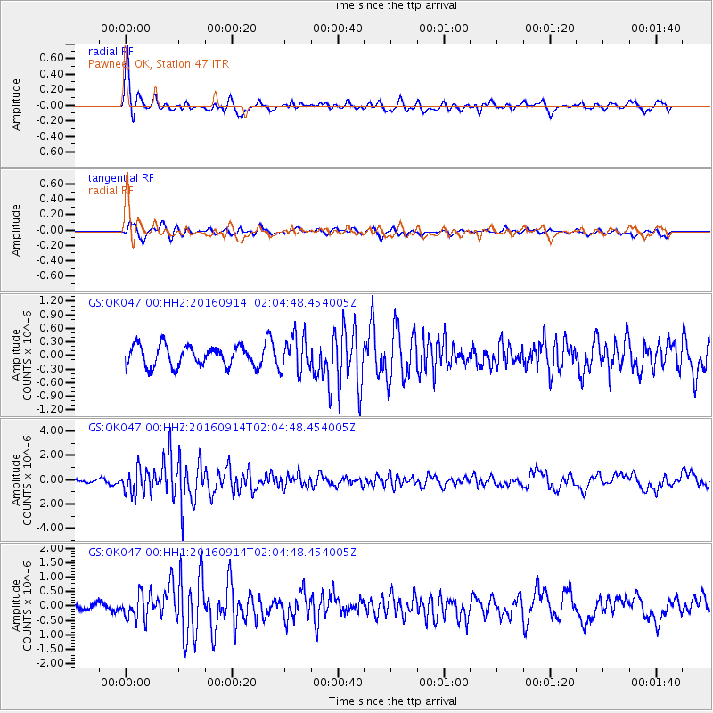
| Radial Match: |
80.51002 % |
| Radial Bump: |
400 |
| Transverse Match: |
78.88013 % |
| Transverse Bump: |
400 |
| SOD ConfigId: |
1634031 |
| Insert Time: |
2016-09-28 01:59:48.721 +0000 |
| GWidth: |
2.5 |
| Max Bumps: |
400 |
| Tol: |
0.001 |
|
Signal To Noise
| Channel | StoN | STA | LTA |
| GS:OK047:00:HHZ:20160914T02:04:48.454005Z | 4.5813303 | 9.929037E-7 | 2.1672825E-7 |
| GS:OK047:00:HH1:20160914T02:04:48.454005Z | 2.648184 | 4.3964602E-7 | 1.6601791E-7 |
| GS:OK047:00:HH2:20160914T02:04:48.454005Z | 1.7409692 | 3.9216695E-7 | 2.2525782E-7 |
| Arrivals |
| Ps | 5.3 SECOND |
| PpPs | 17 SECOND |
| PsPs/PpSs | 22 SECOND |


