You are here: Home > Network List > GS - US Geological Survey Networks Stations List
> Station OK049 E0420 Rd and N3200 Rd, OK, USA > Earthquake Result Viewer
OK049 E0420 Rd and N3200 Rd, OK, USA - Earthquake Result Viewer
| Earthquake location: |
Northern Colombia |
| Earthquake latitude/longitude: |
7.3/-76.1 |
| Earthquake time(UTC): |
2016/09/14 (258) 01:58:30 GMT |
| Earthquake Depth: |
10 km |
| Earthquake Magnitude: |
5.9 MWP |
| Earthquake Catalog/Contributor: |
NEIC PDE/NEIC COMCAT |
|
| Network: |
GS US Geological Survey Networks |
| Station: |
OK049 E0420 Rd and N3200 Rd, OK, USA |
| Lat/Lon: |
36.41 N/97.30 W |
| Elevation: |
327 m |
|
| Distance: |
34.8 deg |
| Az: |
329.272 deg |
| Baz: |
141.077 deg |
| Ray Param: |
0.07754216 |
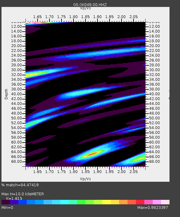
| Estimated Moho Depth: |
10.0 km |
| Estimated Crust Vp/Vs: |
1.62 |
| Assumed Crust Vp: |
6.483 km/s |
| Estimated Crust Vs: |
4.014 km/s |
| Estimated Crust Poisson's Ratio: |
0.19 |
|
| Radial Match: |
84.47419 % |
| Radial Bump: |
335 |
| Transverse Match: |
60.29477 % |
| Transverse Bump: |
400 |
| SOD ConfigId: |
1634031 |
| Insert Time: |
2016-09-28 01:59:51.658 +0000 |
| GWidth: |
2.5 |
| Max Bumps: |
400 |
| Tol: |
0.001 |
|

Signal To Noise
| Channel | StoN | STA | LTA |
| GS:OK049:00:HHZ:20160914T02:04:50.549006Z | 6.340994 | 1.0129833E-6 | 1.5975148E-7 |
| GS:OK049:00:HH1:20160914T02:04:50.549006Z | 3.7175827 | 3.995468E-7 | 1.0747488E-7 |
| GS:OK049:00:HH2:20160914T02:04:50.549006Z | 1.4277003 | 3.38517E-7 | 2.3710649E-7 |
| Arrivals |
| Ps | 1.0 SECOND |
| PpPs | 3.7 SECOND |
| PsPs/PpSs | 4.7 SECOND |


